


Lawson and Gaskill Peaks - Peaks #29 and 30 - Braving the weather

Lawson Peak shrouded in clouds from the Lawson Peak Trail
Lawson Peak
Elevation: 3,664′
Mileage: 4.5
Dates Hiked: 02/07/2010/11/19/2016
Peakbagger.com Page
Gaskill Peak
Elevation: 3,836′
Mileage: +2.5 (added to total above)
Dates Hiked: 02/07/2010/11/19/2016
Peakbagger.com Page
Trailhead: Lawson Peak Trailhead
Agency: Cleveland National Forest
For those interested, here is a list of my gear that I have found works well for me. This is, of course, an affiliate link and your enjoyment of these may vary:
02/07/2010
All week the weather report stated that Sunday was going to be sunny. However, late Saturday night, the weather report changed to showers and sun. On my way to the trailhead, I had to slow the car down on the freeway to 40mph, since was raining too hard to see anything out of my windshield. Since I could see some blue skies to the west, I decided to chance hiking the trail today.
Once I got to the trailhead, there were plenty of clouds, but no rain. I headed up the dirt road, which was also a stream more often than not. I could see some Jeep tread marks in the trail, but couldn't imagine anyone trying to drive up this steep, muddy road today. I encountered plenty of small waterfalls and some giant puddles as I made my way up the contoured road that lead to the ridge line above.
Lawson and Gaskill Peaks were above me somewhere in the clouds. Normally, I can get my bearing based on landmarks, but for much of the first portion of the hike, everything was enshrouded in fog.
Looking down to the valley floor, I could see rays of light poking through the clouds. The day was threatening to be beautiful, but it just wasn't there yet. The clouds were moving above me, rapidly heading to the east.

Dramatic Lighting on the Lawson Peak Trail

Rays of light on the Lawson Peak Trail
I reached the ridgeline and started climbing the boulders of Lawson Peak just as the rain started. It wasn't too bad, so I kept going up. The wet rocks made climbing precarious, and when I neared the summit, the wind started howling. And then it hailed.
Rather than take my pictures and video at the summit I wisely decided to descend out of the wind as soon as possible. Scrambling up and down wet boulders in freezing wind, rain, and hail isn't my idea of a good time. I also did not want to slip and break anything. It's a good idea, especially when hiking alone, to make safe choices.
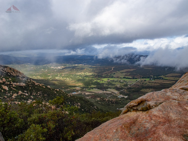
Lawson Valley from just below Lawson Peak Summit
I got back to the trail and headed to the small, unmaintained use trail that leads to Gaskill Peak. It took a bit to find in the rain. From this trail, I could see Lake Barrett, where I went fishing in 2008, glistening in the temporary sun. In a matter of seconds, I was even wetter than before, since the thick brush I was hiking through was soaking wet. The trail follows the ridge, sometimes over large flat rock ledges, culminating in the brush-choked boulder pile that is Gaskill Peak.

Lake Barrett from the Gaskill Peak Trail
By then, I was a little edgy, since I was wet and cold and simply wanted a peak that I could just walk up to, rather than crawl through dense brush or hoist myself up slippery granite. I also was hit with high winds, the second I came close to the peak. After risking life and limb on Gaskill Peak, I again wisely descended to shoot some pictures and video.

Looking up to Gaskill Peak
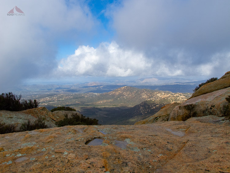
Lawson Valley from near Gaskill Peak Summit
From just below the peak, I could see some Jeeps creeping up the dirt road upon which I had hiked. They must like a challenge. By the time I got back to the junction near the foot of Lawson Peak, the Jeeps (and one pickup) were all lined up on a large outcropping.

Jeep Club near Lawson Peak
As I headed back down the trail, the sun came out and gave me some nice views of the area and of Lawson Peak.

Lawson Peak, as seen from Gaskill Peak
Lawson and Gaskill Peaks Trail Map (Click to enlarge)
Update: I returned to these two peaks on Nov 19, 2016 and met up with a couple of peakbaggers while climbing the ropes on Lawson. We had a great time having a break on the peak and then I continued solo to Gaskill Peak. It was nice to not have any rain that day.

Carveacre Road on the way to Lawson and Gaskill Peak
Panorama looking west from Lawson Peak - Click to enlarge
Lyons Peak panorama from Lawson Peak - Click to enlarge

An alien watches you from Gaskill Peak
