


Corte Madera Mountain and Los Pinos Mountain - Peaks 51 and 52 - The Half Dome of San Diego
Corte Madera Mountain
Elevation: 4,657’
Mileage: 3.35 (one way from trailhead)
Dates Hiked: 01/09/2011, 08/20/2022
Peakbagger.com Page
Los Pinos Mountain
Elevation: 4,805'
Mileage: 3.35 (one way from Corte Madera)
Date Hiked: 01/09/2011
Peakbagger.com Page
Trailhead: Corte Madera Trailhead
Agency: Cleveland National Forest
Total Mileage: 9.7
For those interested, here is a list of my gear that I have found works well for me. This is, of course, an affiliate link and your enjoyment of these may vary:
01/09/2011
Well, we all make mistakes. And sometimes I make them more than once. I know better, I truly do. But sometimes it's in our nature to try for the easy way out, which ends up by being not so easy.
We got a really early start in the morning, meeting at my local coffee shop at 5AM. After a few missed freeways exits due to heavy fog and lack of sleep, we got to the trailhead by 6AM. It was pretty quiet except for the birds. I had a feeling that this was trail that wasn't visited very often.
We got started up the trail and the fog flowed around us. The hillsides and trail were pretty green from the recent rains and the cool air (in the 40s) felt good as we gained elevation. It had been over three months since Brady and I had been hiking together, so we caught up on our respective adventures as we hiked up the trail.
We got up near the saddle between Corte Madera and Los Pinos Mountains and turned around to get a peek into the valley behind us. The fog was lifting at lower elevations, but we were still ascending into the clouds.

Trail to Corte Madera

Espinoza Trail to Corte Madera
Once to the saddle, we could see no more than 50' in front of us, due to the fog. We took a right and started ascending the trail to Corte Madera Mountain. Sage scrub gave way to massive oak and pine trees and the trail was littered with acorns and pine cones. Large boulders appeared out of the fog as we continued to climb the back side of the mountain.

Split Rock in the Fog

Split Rock on a sunny day in 2022
We hiked up and up, wondering all along if the fog would break by the time we reached the summit. We continued to chat along the hike, discussing how beautiful this area was, even without the view. Next thing we knew, we were at the top of the mountain, on the edge of a sheer cliff, with little or no view beyond the white clouds all around it.
It was only 9AM and we had bagged our first peak. We snacked and had some water and in no time, we were cold. The breeze was icy and any sweat on us was instantly chilled. We got back onto the trail and headed back down to the shoulder.

The View Straight Down from Corte Madera
As we descended on the same trail we came up, the mist started to clear. We got a great view into Corte Madera Valley and started to get glimpses of where we had been. By the time we were close to the saddle, we started to get great views of the mountains around us and, ultimately, Corte Madera Mountain.
I've heard Corte Madera Mountain called the Half Dome of San Diego and, once we could see it, it became very clear why.
Sheer granite cliffs ultimately dropping 1,200' to the valley floor below recalls the real Half Dome in Yosemite. We were happy the clouds finally parted, since the view down the valley was a great one. We also finally got a glimpse of Los Pinos Mountain and the lookout tower on top.

Corte Madera Valley
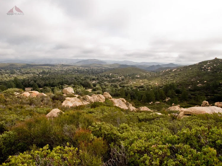
Rolling Mountains to the West

Long Valley Peak from the Espinoza Trail

Los Pinos Mountain from the Espinoza Trail
Once we got back to the saddle, we saw several groups of mountain bikers and a group of hikers. It was great to see people enjoying this area, however remote it seemed.
We chatted with a mountain biker for a bit and then headed up the other side of the saddle, opting to take the fire road, rather than the ridgeline trail under the power lines, which looked pretty steep.

Corte Madera from the Saddle
After being passed by some heavily panting mountain bikers, we looked to the west and saw a great view down the Espinoza Creek watershed. I saw several peaks I've done before, but couldn't recognize them from this angle. I saw Lawson and Gaskill Peaks peeking out from behind a ridge, but they looked different enough that I wasn't sure it was them.
The trail wound around the mountain and continued upward as we were passed by several pickup trucks and dirt bikes. I checked the time and decided to quicken the pace, as it was getting later than I had expected, since the fire road was longer than I had anticipated. I was also getting hungry for a nice, large lunch.

The view down Espinoza Creek Valley with Gaskill Peak, Sycuan Peak, Bell Bluff and Viejas Mountain in the Distance, Among Others
The way to the top took us back into the clouds, so our views into the surrounding areas were intermittent. We passed through a couple of gates and found ourselves looking up at the lookout tower, the only remaining active tower in the county, from what I understand.
I was even hungrier. Scanning the valley below, I noticed some cars parked below. Then I realized that one of them was mine. I saw a ridge line trail that looked like it led directly to the car. It was steep, but looked like an obvious trail that could be easily followed.
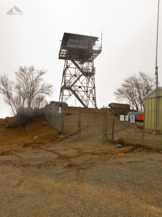
Los Pinos Mountain Lookout Tower
We consulted our maps on our respective phones and determined that the trail was visible on satellite imagery. Except the last quarter mile or so got lost in the brush. Why would the trail stop? we thought. We decided that cutting 2 miles off our trek home was worth the short bushwhacking we would have to do in case the trail didn't make it to the road.
We began our descent along the ridge and found the trail easy to follow. It looked to be a trail to service the now defunct power poles that were spaced down the hill ahead of us. We continued on, being careful in spots that got pretty steep and sketchy. I ended up taking a spill that broke one of my trekking poles and bruised my right arm and wrist.

Old Telephone Pole on the way down from Los Pinos Mountain
I began to wonder whether or not this was a good idea.
We continued downward, dropping elevation quickly and the road got closer and closer. I could almost smell the burgers awaiting us. The wide access trail turned into a narrow path between the brush. We began to find unusual items, such as two shovels, a pair of bolt cutters and even a single aluminum crutch! This apparent ancient and unused trail was littered with signs of modern passage.
We had to push some brush away, but were still making good time.
Suddenly, at about a quarter of a mile from the road, the trail turned and went away from the road. Uh oh. We got out our maps and realized that the trail that we had hoped to follow was merely a brush-choked wash.
We started bushwhacking.
About an hour later, after swearing, crawling on all fours, and basically plowing through brush with branches the thickness of broomsticks, we finally emerged onto the road. We earned that burger. Make it a double.
It would have taken us the same amount of time to walk the nice, graded, open trail. Granted, it would have been more mileage, but there would have been fewer abrasions and expletives.
During our frantic push through the wall of plants, it occurred to us that the trail we were following was likely a trail used by illegal immigrants and by nature would avoid the road at all costs.
Our thesis was confirmed when, on the way back to the main road, we passed border patrol officers supervising some tired-looking travelers from the south as they waited to be picked up and taken back home. We could have encountered a group like that at any time.
Lesson? Stay on the main trail. It is easier and safer. There's a reason why it is there. Most likely it is the easiest way on and off the mountain.
Some of my best trips were the ones I could only laugh about later. We were able to laugh about it by the time we got back to the car. Good times.
Update 2022: I went backpacking with two friends, Jason and Tip near the top of Corte Madera. It was a really hot day, but the evening was wonderful.

Corte Madera from the saddle in 2022

Tip climbing up Corte Madera

Corte Madera summit register from 2022

View from Corte Madera 2022

Sunset from our campsite on Corte Madera

Our campsite on Corte Madera in 2022

