Santa Ynez Peak and Broadcast Peak - Peaks# 5 and 6 - A cold and windy road to the towers
Santa Ynez Peak
Elevation: 4,298′
Date Hiked: 04/01/2012
Peakbagger.com Page
Broadcast Peak
Elevation: 4,028′
Date Hiked: 04/01/2012
Peakbagger.com Page
Total Miles: ~5.2 Miles
Trailhead: W Camino Cielo Turnout
Agency: Los Padres National Forest

Broadcast Peak Masts
04/01/2012
I was pretty excited about hiking this weekend. But then the rains came. And it wasn't just a little bit of sprinkles. It came down hard. As I lay in my bed the night before, dreaming about hiking, I could hear it hammer down on my roof.
I wasn't going to let that stop me. This was the one free day that I had, so I was going to make it count.
I drove up to West Camino Cielo. I have AWD on my Tiguan, but was concerned about the condition of the road. I had never driven this way and I wasn't sure how passable it was on a good day, let alone a day after some heavy rains. I passed through some pretty deep puddles after the pavement ended, but it was a pretty good dirt road.
I knew that the round trip length from the beginning to West Camino Cielo to the base of Santa Ynez Peak was about 18 miles.
As I wanted to get at least a little mileage in, I drove in about 7 miles from San Marcos Pass Road (154). That would leave me about 4 miles round trip of hiking, plus whatever additional distance it would be to go up and down the access roads to the peaks themselves.
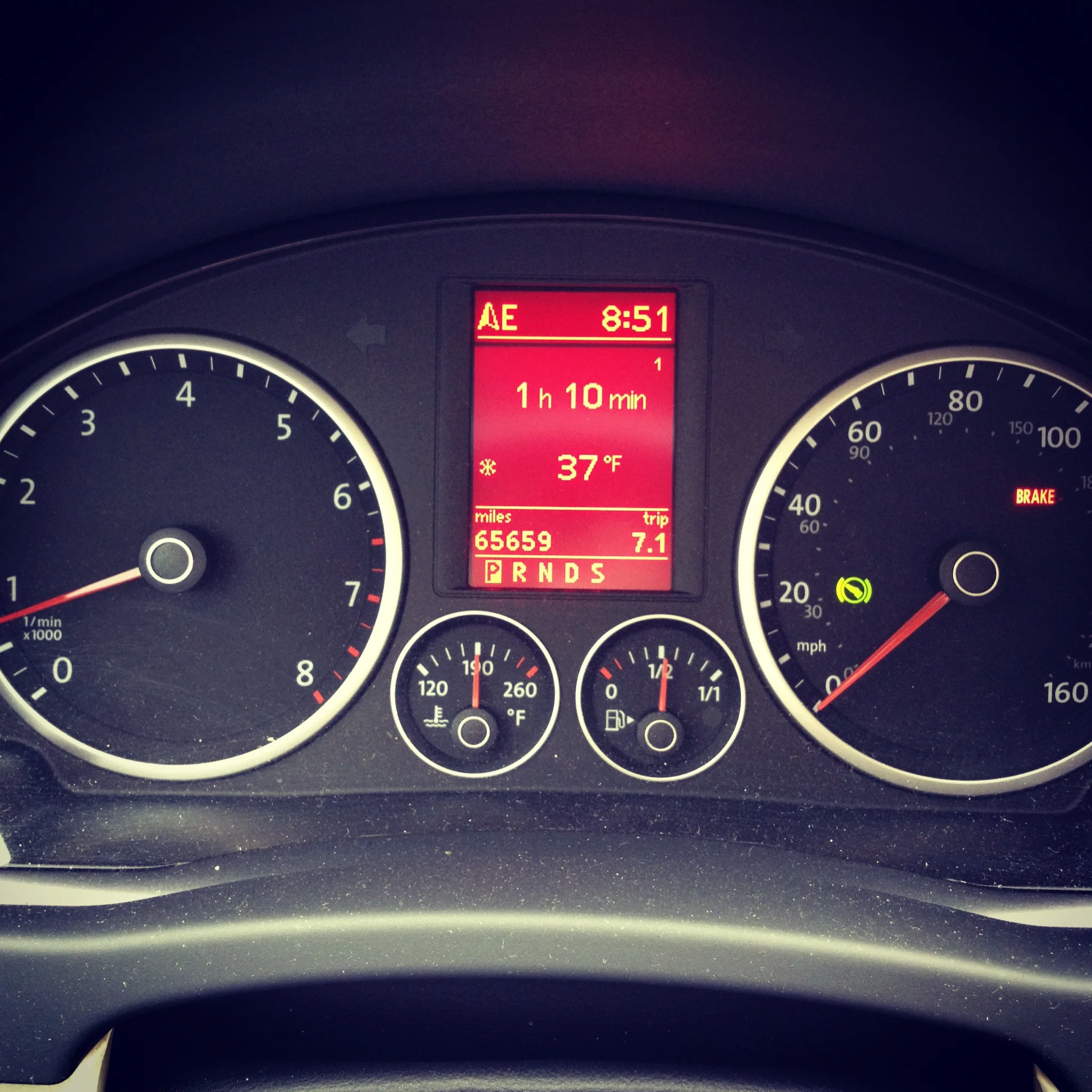
My door was ripped from my hands as I opened it to get out. It was windy up there. Really windy. And cold. It was only 37F at my car.
I was to gain elevation and be exposed to the high wind before this adventure was over. It would feel even colder. I was prepared, though. I had on a merino base layer, some gloves, and my Columbia Peak 2 Peak Jacket.
It was cold as I started hiking
I started down the road and gave the thumbs up to a concerned motorcyclist as I started to get warm. The sun was out over the ocean below, but it was cloudy up on the ridge. I started to see the telltale signs of vehicle access.
Beer cans, cigarette packs, and even coolant jugs were littering the road. I placed some on the side of the road where I wouldn't miss them on the way back and where they wouldn't get blown away by the wind.

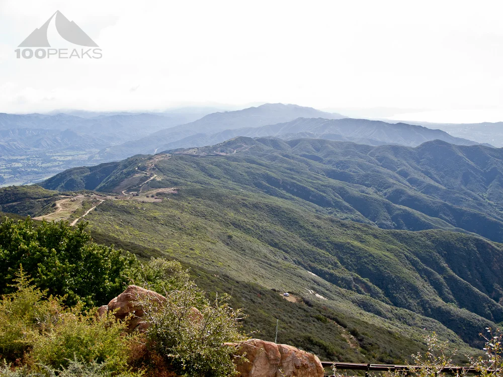
View of the Santa Barbara Coast from West Camino Cielo

West Camino Cielo dirt road to Broadcast Peak
Once again, I was amazed at the views along the coast. This is truly a special place to hike. This particular hike was intentionally easy. It was wet and I didn't want to have to bushwhack through mud and wet brush. I just wanted an easy trail where my mind could wander and work out the kinks as I got my rhythm.

The approach to Broadcast Peak
I found the gate to Broadcast Peak and started climbing the steep gravel.
I was instantly buffeted by high winds, which cause me to stagger to my right. I continued up until I saw something fly in front of me and hit the ground with a thud. I looked up and saw ice chunks landing on the ground.
For a second, I thought it was hailing, but then I realize that the ice was coming from the tall masts above me. Certain parts of the hillside were covered in ice while other parts were getting a chunk here and there.
I skirted as far as I could to the right and made it to the top. As I walked around the communications equipment, I could see into the back country to the north, a dark space on the map that I haven't yet explored, but is definitely calling me. Once I stopped hiking, I got cold pretty quickly, so I jogged back to the fire road, buffeted again by the high winds, causing me to lean precariously forward. If the wind suddenly stopped, I might be in trouble, falling flat on my nose.

Lake Cachuma from Broadcast Peak

The view of the Santa Barbara Coast descending Broadcast Peak
It didn't and I continued on towards Santa Ynez Peak, one of the higher mountains in the Santa Ynez Mountains front range in Santa Barbara.
I rounded a corner and was sheltered from the wind and the sun came out. It was suddenly a beautiful day. My spirits rose and I enjoyed this portion of this trail immensely.

Santa Ynez Peak from West Camino Cielo
I turned the sharp right and climbed to Santa Ynez Peak. More ice was flying all over and it was windier than before. As I rounded the last turn to the top, I spied three trucks parked at the top.
A crew of workers were scrambling in the cold to reassemble and raise a fallen mast. They gave me a quick, surprised look and continued with their work.
I stayed out of their way and hiked to the highest point to look in vain for a benchmark. The high point also was under the tallest masts and had the greatest amount of ice on the ground.

West Camino Cielo back to San Marcos Pass

Looking East along the Santa Barbara Coast from West Camino Cielo
I hadn't seen benchmarks at either peak and was a little disappointed. But I suppose the foundations for the buildings and mast platforms covered up any benchmarks that may have been there.
Again the views were great into the wilderness to the north, as well as up and down the coast. Eager to get warm again, I descended, since I got pretty cold again once I stopped.

Broadcast Peak from Santa Ynez Peak
It was at this point my family texted me to let me know they were enjoying a warm day at the beach. I looked around at the ice and high winds. I was bundled up against the cold and they were about 10 miles away below me, enjoying the sunshine.

My ride, in its natural environment
That was pretty decent motivation to start trail running back to the car. I collected an armful of trash and awkwardly carried it back to my car. Once my car was in view, I got a little excited, like I always do. There was warmth in there.
Santa Ynez Peak Trail Map (Click to enlarge)