Canadian Rockies - A gorgeous change of plans
For those interested, here is a list of my gear that I have found works well for me. This is, of course, an affiliate link and your enjoyment of these may vary:

Saskatchewan Glacier and a host of peaks from Parker Ridge
Sometimes you don't get the trip that you planned, but you get one that you need. Our trip to the Canadian Rockies started out a little rocky.
Our plan was this:
The PD and I would fly to Calgary, drive out to Kootenay National Park and leave our rental car at the Floe Lake Trailhead, where we were to meet our shuttle driver, who would take us to the Paint Pots Trailhead, where we would begin our 3-night stay along the reportedly gorgeous Rockwall Trail, a premiere destination in the Canadian Rockies. We had our permits in hand and were pumped to go. We planned to cover over 34 miles in 4 days and walk out to our rental car. There were scattered thunderstorms and showers in the forecast, but it shouldn't be too bad.
08/18/2015
We left San Diego late due to a delayed flight and barely made our connecting flight in Seattle. We were worried up until the point that our backpacks rolled onto the luggage carousel in Calgary. Then we knew we had dodged a wrench thrown into our plans and still had half a day to purchase some propane and enjoy Calgary.
On the flight, the attendant handed me a can of soda that forecasted our up and coming itinerary.

A timely omen on the plane
We were able to walk around downtown Calgary, buying some last-minute gear and enjoying some food. We called and let our shuttle driver know to meet us later than our originally planned time, so we could get a little more sleep and take our time in the morning, picking up some food for the trail. That night, we packed our backpacks and I felt good leaving a lot of stuff behind.

Visiting the Bow River in Calgary
In the morning, we drove our rental car west along Highway 1 and slowly left the plains behind. The mountains of the Canadian Rockies soon started to loom up ahead, beautiful against a clear blue sky. We were pretty pumped, we had 10 miles to hike, but plenty of daylight, since it was summer and we were pretty far north. Also, the gain on the first day wasn't too great (reportedly 1,150') and the highest elevation we'd reach would be less than 6,000'.

The view on Highway 1
We picked up some sandwiches in Canmore and walked around the cute little town for a bit before heading to Banff and dropping off our duffel bags at the hotel we booked for the way out. As we drove west, the skies got progressively darker, and 10 minutes from the trailhead, the skies opened up and dropped a ton of water on us, accompanying the deluge with booming thunder. Our windshield wipers were on maximum and it was hard to see outside the car. We missed the turnoff to the Floe Lake Trailhead and had to stop and ask for directions. Turns out, there is only a sign for the northbound drivers. We reversed our direction and got there in a matter of minutes.
I was a little nervous, since starting a backpacking trip in a downpour brought back memories of our aborted Chicken Spring Lake trip in 2013.
We met with our shuttle driver and quickly loaded our backpacks into his trailer and hopped into his van with other trekkers, who had just come from the Rockwall Trail. They reported that it was gorgeous and completely worth it. On the 15-minute drive to the Paint Pots Trailhead, it stopped raining and the sun even started shining a little bit.
I told the PD that perhaps the sky had gotten all the rain out of the way and we would be in for a nice and sunny first day in the Canadian Rockies.
We quickly hoisted our packs onto our shoulders, with rain gear at the ready, and headed up the trail.

Ready at the Paint Pot trailhead
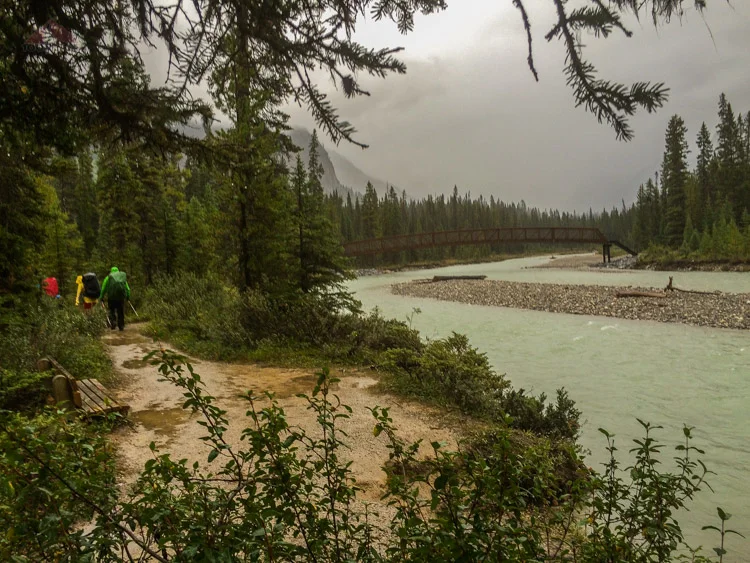
We immediately crossed the Vermilion River and headed to the colorful Paint Pots. We encountered plenty of friendly day hikers who eyed our giant packs as if we were crazy. We entered a deep green forest and knew were weren't in San Diego anymore.

The first bridge, crossing the Kootenay River

One of the Paint Pots
For the first hour, the lush forest protected us from the sun and it actually got a little warm. We had our first break and stopped to eat and shed our outer waterproof layers.

The PD, happy at the first rest stop, one hour into the trip
Once we started back on the trail, it started sprinkling pretty consistently, occasionally stopping to show us some blue sky. This was doable and the hike was very pleasant. In between the occasional groups of backpackers on their way out, we shouted "hey bear!" since we were in grizzly country. We saw one scat, right in the middle of the muddy trail, but no footprints. We were blessed with some sunshine from time to time.

Crossing Helmet Creek
The sprinkles got harder and we got our rain shells on. It turned into rain and the sky opened up on us. We climbed and climbed, thinking this had to be way over 1,100' of gain. (It ended up being only 1,736, but it sure felt like more.) I stowed my camera and phone away in a ziploc baggy in my pack and only took some waterproof GoPro pics of the day.

Crossing one of the several meadows on the Helmet Creek Trail, the rain has started
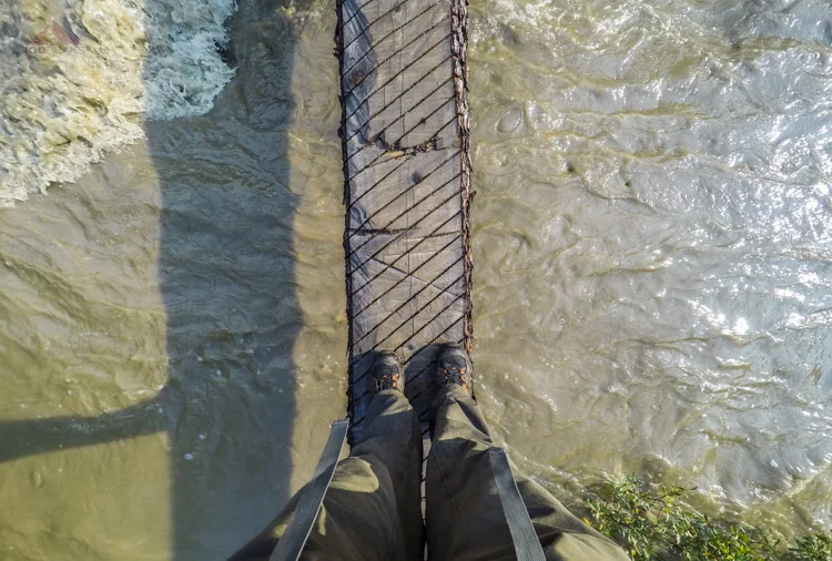
A memorable moment of the day was when the thunder and lightning started. We were walking along Helmet Creek and the lightning exploded repeatedly right above us. We high-tailed it back into the treeline, but were forced to cross the creek again on a metal bridge.

Lightning and thunder directly above us

Crossing a metal bridge during a thunderstorm
For hours, we hiked through the storm, stopping only to wonder how long it would last. The trail was a giant mud puddle and our visibility was limited. We saw mushrooms and berries along the trail. Even through the rain, the lush greenery was stunning. About 20 minutes before we got to our campsite, the rain lightened and the sun started peeking out. I was relieved and was ready to take some inventory and dry out some of our gear.
We saw the warden's cabin through the trees and we knew we were near.

Approaching the Helmet Creek Warden's Cabin and Campground
A final creek crossing and we got to the campground, which was pretty full. One site in the middle was completely full of water. We took a small trail through the trees and found a private campsite, surrounded by greenery. Amazed at our luck, we dropped our packs and got to work setting up our tent.
Crossing Helmet Creek

Looking back over Helmet Creek at the cabin

Our secluded Helmet Creek campsite - trying to dry everything
We hung out some of our gear to dry, taking advantage of the lack of rain. We headed to the dining area, set back away from the campsites, as a deterrent for bear encounters. We enjoyed our dinner at the tables there and packed the rest of our food in the bear lockers. We got back to our campsite and noticed that our gear hadn't dried. It was even wetter than before. The moisture was in the air. This was new to me. No worries, we had a change of clothes and the next day's forecast was for scattered showers. Perhaps there would be a chance to lay some gear out in the sun tomorrow.

Helmet Falls from our kitchen
We got back to our tent at around 9PM and settled in.
It started to rain. And rain.
We were treated to a spectacular light show as the thunder and lightning continued throughout the night. I heard the creek below our campsite get louder throughout the night and it occurred to be that it might actually overflow, threatening our safety.
There was no lull in the rain. We both slept fitfully, as the rain pulsed against our tent. Some drops here and there penetrated the tent's waterproofing and dripped onto us. My last thought as I fell asleep in the early hours was that the sun in the morning would feel great.
We woke up to the sound of rain on our tent. The water hadn't stopped coming down since 9PM the night before. It was 8AM now with no end in site. The PD and I discussed this day's options.
Did we really want to endure the Rockwall Trail, or enjoy it? Did we come all the way up here to merely survive 4 days of thunderstorms? We had a pass and a large plateau to cross today and we were worried about the very real risk of lightning. I was used to being able to dry out my wet clothes and boots, but that didn't happen. If anything, they were wetter than the night before. We decided to have some breakfast and see how we felt about the weather.
We were the last ones out of our tents. Other groups had already packed up and headed up the trail. We ate our breakfast and headed out to Helmet Falls in the rain.

A morning stroll to Helmet Falls

Helmet Falls
Along the way to the falls, we decided to head back down the mountain. We had hiked nearly all day yesterday in the rain and slept an entire night in the rain. The weather didn't look like it would change any time soon. I didn't want to hike the Rockwall Trail if I couldn't see it, or enjoy it. I also didn't want to get struck by lightning.

Heading back down the mountain
After a pleasant hike through the trees and a brief stay near the base of the falls, we packed up our camp and headed back down the mountain. The rain continued. We made good time and enjoyed our time on the trail. The rain wasn't quite as hard as the day before, but it was still pretty steady. We were, more often than not, walking in muddy puddles. The rain momentarily slowed to a sprinkle, so we stopped to enjoy a lunch overlooking the canyon.

Having some lunch on the way down
After about 6 miles, we were approaching the lower campsite and the rain stopped. We even saw some blue between the clouds. The PD gave me a proposition: "If I can get a fire going and the weather stays good, should we stay another night out here?" I said yes. That would do. The lower campsite is a rarely-used collection of 4-5 sites, a kitchen area, a pole to hang food, and a pit toilet. Most people bypass this site on the way in to shorten their number of nights on the Rockwall Trail. The bonus part is that they allow campfires and it's a scenic location right along the river.

Lower Helmet Campground is on the other side of the bushes
He got a fire going in no time. Feeling some warmth, I immediately felt good about his idea. I hung some clothes in a tree near the fire as we scoured the area for any dry wood we could find and scoped out the campsites. We sat down at a picnic table nearby and relaxed, smiles on our faces.
Then it started raining. And then it got harder. Our spirits sank. We decided to wait until 5PM to see if it would let up. It rained harder. The rain had put the fire out, so we gathered our gear and headed down the mountain. It was after 5PM and we had between 4-5 miles to go, and we still had to figure out a way to get back to our car, which was 8 miles down the road, at a different trailhead. We'd cross that bridge when we came to it.

Still happy and still raining
We headed down at a pretty good pace. The trail was great. It was well-defined and a gradual descent at that point. It was as lush and beautiful as the day before.
We were getting close to going over 20 miles in two days, but our spirits were up. We were convinced that we were making the right call. We reached the junction where we had stopped for lunch the day before. We knew we were less than an hour from the trailhead. We chatted with a couple headed up the trail we came from. It was late and raining, but they were going to the lower campsite.
Just then, a group of people came down from the Tumbling Creek Trail. They had been backpacking the Rockwall Trail in the reverse direction and had had enough of the rain, too. They cut their trip short one day and were headed to the Paint Pots Trailhead. I asked them if they had a car and if they wouldn't mind giving us a lift to the Floe Creek Trailhead. Since they were Canadian, and almost all Canadians I've ever met have been extremely nice people, they said yes.
So we hiked the rest of the way with them and got to know them a little bit. A father and a college-age daughter, along with the daughter's friend, had hiked the Rockwall Trail starting from the Floe Lake Trailhead. They had been rained on all day yesterday, but they had made the best of it. Now they were over it and were heading out a day early. We slowed to their pace and it took about an hour and 45 minutes on the way out, but it was a nice trade for a ride to the car.
Almost to the car
It rained the whole way.
Once we got to the trailhead, we decided that the PD was going to ride with them, since they had only one extra seat available, and he would come back and get me. I dropped my pack and took shelter under the trailhead sign. The little roof of the sign offered me some shelter from the rain, and it made a big difference. I was soaked to the skin.
I had about a half an hour before the PD returned. I watched as the sun peeked out from somewhere far away and created a rainbow across the sky. I enjoyed the smell of the damp forest while I could.

Back to the trailhead

There's always a rainbow, somewhere
We had been out about 33 hours and it had rained about 30 of those. It seemed like we had seen so much on just an overnight trip. We weren't sure what we were going to do, but we weren't going to waste our time in the Canadian Rockies.
The PD picked me up and we headed back towards the town of Banff. Once I got a signal, I was able to get a room at the hotel where we were going to end the trip. I then called other hotels in town and checked online and everything else was booked. So we decided to stay there. Once back to the hotel, we decided to stay there all three nights and booked one more.
We hauled in our wet gear and hung them up to dry. This time it worked. We scoured the maps and decided we'd do the tourist thing tomorrow. It rained throughout the night.
We woke up and had coffee in Banff before we walked up and down its streets. Charming stores and restaurants line the town and the bow river runs through it.

The charming town of Banff

The Bow River in Banff
We then headed north toward Banff National Park and saw thick dark clouds hovering over Kootenay National Park and the Rockwall Trail. We had made the right call. We parked at the crazy parking lot at Lake Louise. Immediately, we were smitten by the beautiful lake and understood why they built a chateau on its shores.

Lake Louise in Banff
We then left a majority of the crowd and headed up the mostly paved path to the Lake Agnes Tea House. We kept a pretty fast pace as we ascended quickly away from Lake Louise. Most of the crowds stayed below, but this path was still pretty popular. After a while of pushing ourselves, we made it up to the top and were rewarded with beautiful views in both directions. To the east, we could see across the Bow River Valley to the Sawback and Vermilion Ranges.

The view from the Lake Agnes Tea House
Right before us, was scenic Lake Agnes, and its famous teahouse.

Panoramic of Lake Agnes and the Tea House

Lake Agnes
We decided to have lunch on the deck of the teahouse, where it is cash only. We ordered some sandwiches and coffee. It took a while, but it was worth it. We shared our table with a couple from England and enjoyed each other's company. It was a little chilly up there with the wind whipping up from the west, but the coffee warmed us up.
We said goodbye to our new friends and hiked most of the way around the lake. There was a trail that led to the Beehive, but I was a little tired from the last two days and was ready to start heading back down. We hiked back to the teahouse and arrived as hail started to drop from the sky. We pulled out our waterproof layers as most people either shivered under the awning of the teahouse or pulled on their plastic ponchos. Once again we set a good pace down the trail. It was nice, since it was mostly paved and we were protected from the heavy rain that was falling. My rain shell was bright green and the PD's was bright yellow. A mother with two kids pointed to us and said, "Look! Lemon lime!"
It was nice to know that we would have encountered another day of heavy rain in the backcountry and we were now on our way back to a hotel. It rained on us all the way back to the car and most of the night. We enjoyed some time at the jacuzzi at our hotel, which had a great view of the area around Banff.

The view from the hotel Jacuzzi
We asked the hotel staff, "If you had one more day in the area, what would you do?" The Icefields Parkway was the answer. We grabbed a map and planned our next day.
Once again, we headed north of Banff, and, once again, it was raining. As we drove north on the Icefields Parkway, however, the sun started to come out. We pulled off to the first scenic stop and were once again blown away by the beauty of the Canadian Rockies.

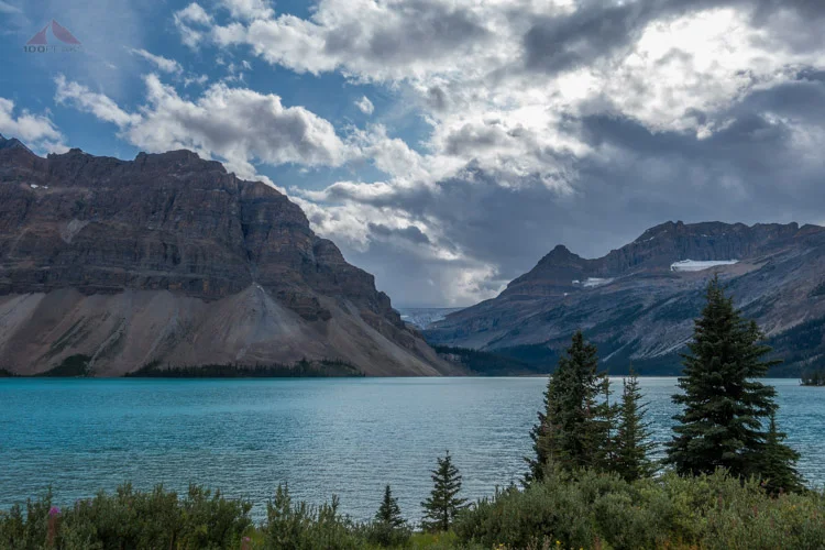
Bow Lake
Bow Lake was a drive up view and it was amazing. We sat there, enjoying sun warming us from the cool morning air. We got in the car and continued driving.
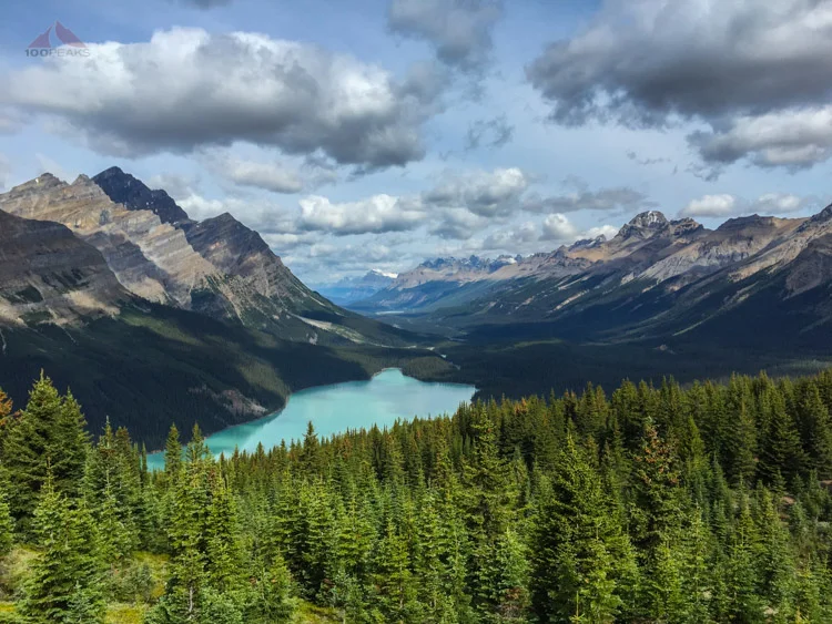
The next stop was Bow Pass and we were ready to start hiking. We hiked uphill to the wooden deck viewpoint and shared the view with busloads of people. We decided to hike a little higher to see what we could see.

Peyto Lake and the Misaya River Valley
As we hiked south, away from the crowds, a couple from Barcelona asked if they could join us, since we looked so confident and they weren't sure where to go. We emerged through the trees and climbed up a steep slope. We made it to the top of a bald hill and were treated with a view of a lifetime. Glaciers to our left and a beautiful valley to our left, we stood in the intermittent sun and took some deep breaths and plenty of pictures.

Peyto Lake Pano

The PD at the top

Peyto Peak from Bow Pass
We bid adios to our Spanish friends and headed back down to the car. It was nice to stretch our legs and we were curious to see what else we could see.
We stopped at a couple of viewpoints, but were really ready to start hiking again. We made it to Parker Ridge and headed up the trail.

The Parker Ridge Trail
It was pretty steep and there was some elevation. We made it to the top and someone along the trail urged us to keep on going, we hadn't seen "the view" yet. We continued on and knew what she meant immediately.

Me at the end of the Parker Ridge Trail
Saskatchewan Glacier and a host of peaks from Parker Ridge

The PD, contemplating the Saskatchewan Glacier
We sat down and had a snack. We enjoyed the view immensely. These were the Canadian Rockies, in all their splendor. We had glaciers, peaks with cliff bands, gemstone blue lakes, and lush green forests. We hung out for quite a bit before resolving ourselves to going back to the car. Even the way back treated us with great views.

The PD, hiking along Parker Ridge

Hiking down Parker Ridge, looking into Narrow Canyon
We made it back to the car and headed north. The day was getting late, but we wanted to see a glacier up close, so we headed to the Athabasca Glacier. We parked in the lodge parking lot and had some lunch and then headed down across the highway to the glacier. Interesting to note were the markers that showed the rate of recession of the glacier. It made a strong impression on how our climate has changed in our lifetime.

Athabasca Glacier

Sunwapta Lake
After a full day of hiking and driving, it was time to turn back and head to Banff. We momentarily got stuck behind a group of cars that saw a bear off the to the side of the road, but we didn't see any bears this trip. We decided to squeeze in one more hike. so we stopped at Mistaya Canyon.
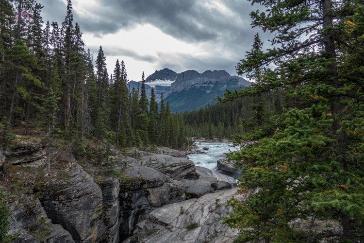
Mistaya River Gorge
We weren't sure what to expect, but found a narrow gorge with the boiling Mistaya River running through it. The water was light blue and made a pleasant sound as we sat there, having a final snack and enjoying our final time out here in the Canadian Rockies. Reluctantly, we made our way back up to the car and drove back to the hotel to pack and get ready to head home.
While stopped in traffic, as there was some road construction happening on the parkway, I stopped to reflect on the experience of this trip. While it wasn't exactly how I had planned, it ended up being a great way to spend time with the PD. We always make the best of every situation and this was no different.
To put a footnote on just how gorgeous this area is, I took a picture from the car, shooting out the window, while sitting in traffic.
Bow Lake with Bow Glacier in the distance, on the way out
It's hard to take a bad picture out there.