


Peak 96 - Pyramid Peak - A walk on an ancient Cahuilla Trail
Pyramid Peak
Elevation: 3,500’
Mileage: ~9
Trailhead: Turnout along the S-22 across from the Thimble Trail
Agency: Anza-Borrego Desert State Park
Date Hiked: 01/19/2023
Peakbagger.com Page
For those interested, here is a list of my gear that I have found works well for me. This is, of course, an affiliate link and your enjoyment of these may vary:
01/19/2023
I pulled into the trailhead parking area. My car was the only one there. It was just a dirt lot off of the S-22 highway. I had been there three times before, in my visits to the Villager Peak ridge to the west. This time my eyes were to the northeast.
Santa Rosa Mountains from the trailhead to Pyramid Peak (Click to enlarge)
I fired up my stove and made myself some coffee while I eyed the thermometer. It was 38F outside and the sun was still below the horizon. The wind was still.
I enjoyed my coffee and breakfast as I changed into my hiking shoes and layers. It was 6:30AM. I had set my alarm for 3:45AM. Apart from the occasional car flying by along the S-22, there was no sound except the crunch of my shoes on the desert floor.

Dawn in the desert
Looking ahead, I could see the southeastern edge of the Santa Rosa Mountains rise steeply above me, with ridges radiating from its crest and widening washes in between them. Snow-covered Toro Peak was high above me to the northwest.
I was headed to Palo Verde Wash and quickly spotted my destination. I could see a slope of lightly-colored soil or rock on the right side of the wash. I knew the trail would head out there and kept that in my sight as I started hiking up the gentle slope of the wash on the desert floor.

Palo Verde Wash, the trail leads to the white ridge on the right

Snow-covered Toro Peak in the distance
I was excited, as it had been a while since I had been out here alone. I had gone backpacking in the southern part of Anza-Borrego Desert State Park about three weeks earlier with my daughter.
That had been to attempt another peak, but the wind had stopped us from heading up to the higher reaches of the Jacumba Mountains, so we hadn’t done too many miles. We still found solitude and beauty, however.
Today, the weather was perfect.
The desert wasn’t as green as I had hoped, but I knew the rain fell less on this part of the desert than it did near Cougar Canyon and other places closer to the Laguna Mountains. Still, there were yellow and purple flowers here and there, as well as some short green plants emerging from the sandy ground.
While researching my routes in the desert, from the satellite view, it invariably looks like a smooth walk until I hit the mountains. However, once I am on the ground, there are always washes and gullies of varying intensity to be crossed, not to mention rocks and bushes or varying size.

Old prints in Palo Verde Wash
Still, it was a comfortable stroll, as the ridge to my right kept the sun from shining on me for the first part of the hike. I warmed up quickly and enjoyed the quiet morning as the wash slowly narrowed around me.
Once I dropped into the sandy bottom of the wash, I could see some footprints in the sand going both directions. Dogs aren’t allowed in Anza-Borrego, so the clear canine prints I saw were very likely from coyotes. Any other prints were from before the last storm and were very faint. I didn’t anticipate seeing anyone on this hike.

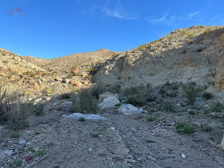
The Cahuilla Trail starts just past the smoketrees on the right
As the wash further narrowed, I started scanning the right side for signs of a trail. I knew the trail emerged at some point near a couple of prominent smoketrees.
After walking past the second tree, I could see what looked like steps carved into the soft rock. I checked my GPS and, sure enough, this was the start of the ancient Cahuilla Trail that heads up and over the pass far above me.

The Cahuilla Trail starts here, with steps in the rock

Looking back to the trailhead from the start of the Cahuilla Trail
The trail continued steeply on the climber’s right side of the side gully. I could see the remains of a mine, known as the Moly Mine, named for the supposed goal of extracting molybdenum. The hillsides were made of a variety of rocks, some folded, in different colors.

The Moly Mine across the drainage
Occasionally faint, I lost the trail from time to time, but easily found it a little further up, as it switched back steeply on a small ridge between two gullies as it ascended to a pass between Palo Verde and Smoketree Canyons.

The faint Cahuilla Trail leads upward

Bighorn sheep leg along the trail

The trail heads up to the pass on the right

Almost to the pass
After climbing over 1,000’ to get to the pass, the trail relented a bit, descending down to the left to Smoketree Canyon, with the first views down to the Truckhaven area of the desert.
Some parts of the trail were a little washed out, requiring some careful stepping with trekking poles, but it was really nice to be dropping some elevation as the sun emerged from behind the ridge to the east.

At the top of the pass looking toward Smoketree Canyon
I could see down into Smoketree Canyon, its steep walls occasionally narrowing the canyon into a hallway. I briefly lamented the fact that I wouldn’t have time to explore it today. I had a dinner date with some friends and a 2-hour drive home. However, it gave me a great excuse to return.

Smoketree Canyon from the trail

Looking down Smoketree Canyon
Since time was potentially an issue, I decided to take the Cahuilla Trail the entire way, rather than exploring the nearby sheep tanks and making a loop out of the ridgelines on either side of Pyramid Peak. I dropped down to the sandy canyon bottom, enjoying some flat sections and taking a break on a boulder.

Pyramid Peak is around the corner to the left, but first you have to drop to the canyon floor

Flowers in the desert
I enjoyed the silence and lack of wind, as I drank some water and had a snack. Scanning the canyon floor, I could see very faint footprints, but nothing recent. I continued up the canyon, scanning the right side for evidence of the Cahuilla Trail.
Smoketree Canyon
Finding nothing obvious, I consulted my map and discovered that it was right in front of me, but barely visible. I climbed up the steep side of the canyon, carefully following the faint trail until it disappeared.
I scanned to the left and right, completely losing the trail. I knew the trail would crest the ridge to my left, so I headed that way, coming across a small cairn that led to the north and I found the trail again as it undulated between drainages and ripples in the ridge.

The Cahuilla Trail leading up and out of Smoketree Canyon
As the trail crossed a gully here and there, sometimes it would be difficult to see it on the other side. However, persistence always paid off and I would pick up the trail on the other side.

The trail continues high along the side of the canyon
The trail then entered a large gully and disappeared. I stayed above the gully on the climber's right until the map indicated I was to cross. I scanned the left side of the gully and saw what could be a trail further up. I scrambled steeply up the side of the hill until I picked up the trail again, angling diagonally up the hill to crest a ridge. All of this trail-finding was using up precious time.

Wonderstone Pass in the distant left with Pyramid Peak on the right
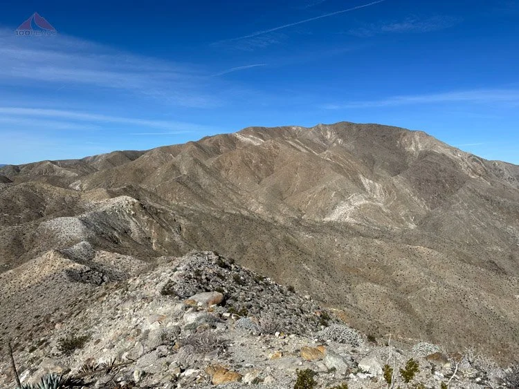
Once I got to the top of the ridge, Pyramid Peak loomed directly above me. The Cahuilla Trail angled to the left and headed toward Wonderstone Pass. Pyramid Peak looked so close, although still high above me.
I looked at my watch and my map. I could shave off some distance, and hopefully some time, by ascending the ridge I was on to the northeast directly to the summit, rather than turning north toward the pass and then following the ridge to the peak.

The steep ridge to Pyramid Peak. I do not recommend
I don’t recommend this. Following the trail would have been much easier and safer. However, I was up for a climb and went directly up the ridge. Again, if I had the time, I would not repeat this. Give yourself the time and stick to the trail, faint as it is at times.
As I followed the trailless ridge, it became steeper and looser. I scrambled from rock to rock, attempting to avoid slipping on the loose soil and gravel that would tumble down behind me. I looked above me, as the ridge became nearly vertical. The peak was up there somewhere.
As I navigated between boulders, cacti, and sand, I gained about 700’ in a third of a mile, which is very steep. Again, I do not recommend going this way and the map below will show the trail.
Pyramid Peak panoramic photo (Click to enlarge)
I made it to the top of Pyramid Peak and enjoyed the view. To the northeast, the Salton Sea spread out across the wide valley below. To the southwest, Borrego Springs could be seen in the distance.

Look down to Borrego Springs from Pyramid Peak
To the north, I could see the use trial to Wonderstone Pass and another use trail to Marble Peak, which was potentially on my itinerary for the day, but would have to wait until another time. It was already getting late. Also looming far above me was Rosa Point, another peak for another day.

The ridge down to Wonderstone Pass
Rosa Point from Pyramid Peak
I sat on a boulder and briefly enjoyed the view as I drank some more water and ate another snack. It was wonderful to be up there, but getting up is only halfway.

Wonderstone Canyon, with interesting geologic formations
I headed north along the ridge and encountered several interesting types of rock. Below the peak to the east, is Wonderstone Wash, known for the stone that the Cahuilla would travel far to harvest, making tools and trading with other nations.
It stood out brightly against the darker granite. Evidently, the Cahuilla Trail continues over Wonderstone Pass and descends to the rock outcrop and beyond making it all the way down to where Lake Cahuilla used to be.

The ridge to Pyramid Peak

Looking back up to Wonderstone Pass
I quickly packed up and headed down the ridge toward the pass, making it in no time. At the northwest edge of the pass, I picked up the Cahuilla Trail which angled steeply to the south as it descended back to the ridge. It occasionally disappeared as I crossed some gullies. More often than not, scanning the other side of the gully would reveal the trail meandering through the cactus and rocks.

Descending on the Cahuilla Trail
As quickly as I could on the steep and loose trail, I descended the way I came, almost slipping a countless number of times. We always wish for downhill, but when you’re losing 1,500’ in 1.4 miles on loose ground, your legs and mind can get tired due to the focus required to stay safe.

In a large gully on the way down from Pyramid Peak, some water in a depression
I carefully descended the way I came, losing the trail again near the bottom of Smoketree Canyon, but never getting lost. I relaxed for a few hundred feet at the bottom of the canyon until I had to climb again on the other side, making my way back up to the small pass that I reached in the morning.

Back at the first pass, ready to descend again
On the other side, I was presented again with the steep trail I had ascended in the morning. I, again, carefully descended, nearly slipping on multiple occasions. I was happy when I finally made it to the bottom of the wash.

The final drop back to the desert floor
It was only about a mile and a half back to the car, but I could see it twinkling in the afternoon sun for what seemed like forever as I navigated around cacti, small drainages, and berms. There was another car at the trailhead, but no one anywhere to be found.
I changed out of my shoes, turned back to look at the ridgeline above, and sped off on the highway, happy to have had a quiet day in the desert with perfect weather.
I will definitely be back to explore Smoketree Canyon and the sheep tanks.
Pyramid Peak Trail Map (Click to enlarge)

