


Yatsugatake Ridge - Stormbound high on Mount Akadake in Japan
Yatsugatake Ridge - Mount Akadake
Elevation: 9,511’
Route: Yatsugatake Sanso to Akadake Tenbou-so via the Jizo Trail
Miles: ~10
Trailhead: Yatsugatake Sanso
Dates Hiked: 06/29/2023 - 07/02/2023
Peakbagger.com Page
For those interested, here is a list of my gear that I have found works well for me. This is, of course, an affiliate link and your enjoyment of these may vary:
Prologue
I stood, sipping my coffee, and looked out the window at the white mist obscuring our view. The building shook from wind gusts, and rain hammered on the windows and walls, as if a firefighter stood outside with a hose. I could see my breath inside the hut.
My daughter Sophia sat at a low table under a quilt that covered her lower half. An electric rug was under the table, keeping us warm.
We were at about 9,000’, enjoying the hospitality of the Akadake Tenbou-so, a mountain hut high on Yatsugatake Ridge in the middle of Japan.
We were over two weeks into a two-and-a-half week family trip across Japan. This backpacking trip with Sophia was to be a three-night trip traversing Yatsugatake Ridge while my wife was training Aikido in Kyoto.
It was interesting to be this cold, as we had experienced very warm temperatures as we had traveled across Japan over the last two weeks.
Our plan was to stay in three huts, spaced out along the ridge, spending four days hiking approximately 21 miles, spanning most of Yatsugatake Ridge. We had reservations for all three huts and were not carrying tents, sleeping bags, sleeping pads, a stove, or fuel.
Our packs were light and we were confident we’d enjoy hiking around 5-6 daily miles, even though the ridge was said to be fairly technical. We only carried clothing, water, lunches, and snacks.

Our first view of Yatsugatake Ridge from the taxi, shrouded in clouds
Day 1: Yatsugatake Sanso to Akadake Tenbou-so - 4.85 miles - 4,105’ of gain
06/29/2023
Earlier in the day, we took four trains and a taxi from Kyoto. We intended on starting our trek at a mountain hut called Akadake Sanso, but the taxi driver saw the dirt road and dropped us off at Yatsugatake Sanso, adding about 2 miles to our hike for the day.
It just goes to show that you can research like crazy, but you still don’t know the conditions until you are on the ground.

Having a little lunch at Yatsugatake Sanso

Excited to get started backpacking up to Yatsugatake Ridge
We walked into Yatsugatake Sanso and decided to order some lunch: ramen and curry. We filled up our water bottles and chatted with the friendly staff. They asked us where we were headed and let us know that they were the ones we were to inform of our arrival at Akadake Tenbou-so. He said it would take us over 6 hours to get there, so we should have our headlamps ready.
I checked the route on my phone. It appeared that it was a little under 5 miles with around 4,000’ feet of gain. It was going to be longer than our original route of about 3 miles with 3,400’ of gain.
It wasn’t nothing, but I was wondering why it would take us that long. We usually go about 1 mile an hour at our absolute slowest while on a trail.
It was only noon. I was confident we wouldn’t be needing headlamps to go 5 miles.

At the trailhead to Akadake on Yatsugatake Ridge
After lunch, we headed out on the trail, starting through the forest on a warm and humid day. We were grateful for the shade, but also wondered if a car would pass us on the way up, so we could reduce the road walking we were about to do. Many cars passed us headed down, but none on the way up; no one would be picking us up.

Making our way up the dirt road

Crossing the Yanagawa River for the first time
We were excited to be in Japan and enjoyed the sights and sounds of different birds. Exotic flowers bloomed along the trail. We made great time as we crossed the Yanagawa river, followed the road, and made it to Akadake Sanso. A family was there, serving the hut, and we decided to enjoy some soft serve ice cream. It was the best we had on the trip. And we tried a LOT of ice cream over the past two weeks.

The road was lush

Getting the best soft serve ice cream so far at Akadake Sanso
We crossed the river again and entered the single-track trail, where it immediately became apparent why this trail might take longer than trails we were used to. The trail was a steep use trail through rocks and roots, crossing and recrossing the river. Sometimes hands were needed to scramble up rocks, but it was all damp and slippery, and very technical.

Starting the Southern Trail
It appeared that trail-building, in the sense that we knew, didn’t occur here. At least on this trail. It was simply a worn path in a densely wooded forest drainage, not a dirt path where we could get our rhythm. There were many slick river rocks and roots in the trail.

The trail is very rocky and rooted

There was a lot of water along the trail
We saw some day-hikers from time to time, making their way back down to the trailhead.
We steeply climbed until we came to one of the many metal mesh stairs installed into the hillside. Gasping from time to time at the steepness, we continued up until the trail leveled out and followed a gully up to a wide rocky riverbed.

The trail flattened out and followed a wide wash

Our first glimpse of Akadake Tenbou-so hut from Gyoja Goya
We made it to Gyoja Goya, another mountain hut with rooms and food and got a good view of the next leg of our journey, and another reason why today’s hike might take longer than usual.
In the next .7 miles, we would be gaining over 1,200 on the Jizo Trail’. What that looked like to us was a sheer cliff above us with a side ridge radiating down. I wondered why I hadn’t noticed this on the trail’s profile and I also wondered if I was up to the task. This was twice the slope of what I normally call, “Very steep.”
After a nice rest at the hut on a picnic bench, we started up the trail, which immediately was steep. More steps were installed into the hillside and they became more like ladders. It was tough, but it was also pretty fun.

The Jizo Trail climbing straight up the side of the ridge
We turned to look and could see the valley in the distance. We had already climbed pretty high. It was getting windy and chilly as the clouds sped by us. It seemed we were climbing into the fog.

A view into Chino and Lake Suwa from the Jizo Trail below Yatsugatake Ridge
“Whoa!” Sophia exclaimed as she easily scaled the steps ahead. “There’s a shrine here. It startled me.” There was a small statue of Jizo on the trail, wearing a bright red bib.

A Jizo shrine, protecting us along the way
We continued to climb, using chains, steps, and ladders to get to the spine of the ridge. It was even steeper than before and the wind was picking up.

We climbed the steep Jizo Trail into the clouds

More steep ladders along the Jizo Trail
As the clouds closed in around us, we made it to the top of the ridge. Another Jizo shrine and a signpost welcomed us. Under the low clouds, we could see the valley to the east as we were buffeted by the wind.

Another Jizo Shrine at the top of Yatsugatake Ridge

Signpost at the top of Yatsugatake Ridge

Our brief view down to Minamimaki before the clouds came in for good

A view down to Minamimaki from Yatsugatake Ridge

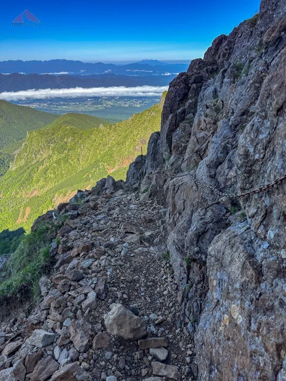
Knife-edge exposure along Yatsugatake Ridge
We took a right, straddling the knife-edge of the ridge. As we climbed, the wind parted the clouds for a second and we could see the Akadake Tenbou-so hut above us. It looked unreal.
“Soph!” I said over the wind, “Look up!”
She looked up and gave me the thumbs up. We were almost there.

Akadake Tenbou-so revealed above us in the clouds
After a quick climb along the ridge, we were at the hut. We found the front door and got inside, grateful for the shelter.
We checked into the hut, paying in cash, and was told that dinner would be served at 6PM. I checked my watch. We made it in around 5 hours. Less than the 6+ hours we were warned about. It still took longer than expected, but I was happy with our time.
I was glad we didn’t have to do the last part in the dark.
We were introduced to the labyrinth of buildings that were connected via a tunnel. We settled into our room.
As we had dinner, we noticed there were only three other guests eating in the main room. We were hungry from the climb, so a hot dinner with roasted chicken was very welcome.
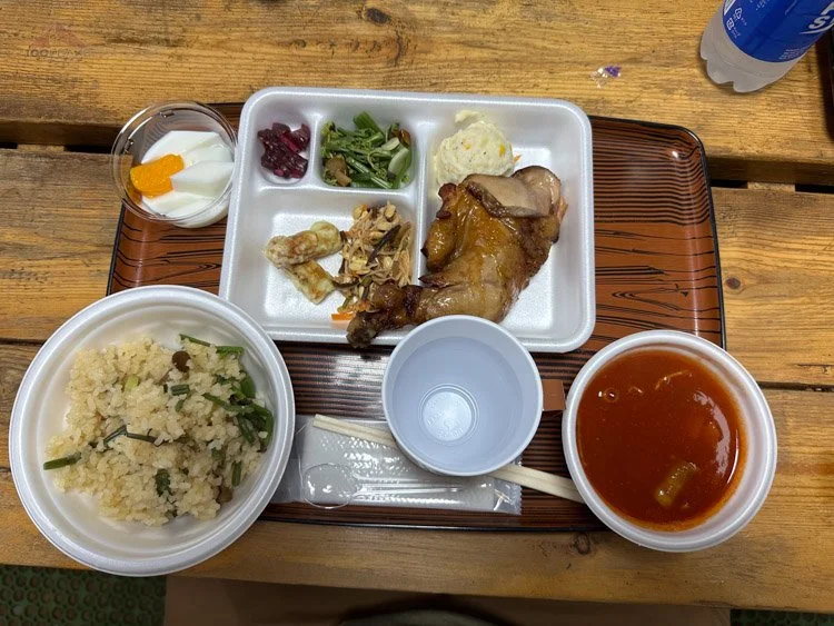
Our first meal at Akadake Tenbou-so
After dinner, we went into the “chat room” at the end of the upper hallway. A large kerosene heater hummed in the middle of the room, keeping the chill at bay. Two young Japanese men watched some local TV. Through pointing and Google Translate, they asked us where we were from and what our plan was.
A large topo map was spread out on the table before them. I let them know our plan and they looked at each other.
“A big storm is coming,” one gentleman shook his head and showed me his Japanese weather app, which looked far more accurate than mine. It showed lots of rain and high wind speeds.
They recommended I stay one additional night here at this hut, altering my itinerary and exiting the ridge at a different spot. I thanked them for the recommendation, but in the back of my mind, I was confidently wondering about our ability to navigate the ridge in a storm.
We went to sleep to the sound of the wind outside.
Day 2: Zero Day at Akadake Tenbou-so
We woke up to howling wind and sideways rain. We would not be traversing the ridge today. I messaged the furthest hut along the ridge where we had a reservation and let them know we wouldn’t be visiting them this trip. There was no way we would make it that far. They let me know they had been worried about us and were glad we weren’t attempting the hike. They understood about the weather and were gracious about the last-minute cancellation.

Our first morning in our room at Akadake Tenbou-so

Breakfast at Akadake Tenbou-so
I reached out to the second hut along the ridge and asked if they happened to have an availability for one night later than we had originally reserved. Using Google Translate via text message, they confirmed that they had availability, as many people had canceled due to the weather.
We would be staying another night at the Akadake-Tenbou-so hut. The other visitors had risen very early and quickly descended back into the valley below. We were hoping to be able to continue along the ridge the following day.
In the meanwhile, we were the only visitors in the hut. We paid in cash for another night with meals and settled in for a quiet, relaxing day indoors.

Upper floor dorm hallway at Akadake Tenbou-so

Lower floor Hallway at Akadake Tenbou-so
Once again, we strolled around the hut, sipping coffee and tea, looking out the windows at the crazy weather and raising our eyebrows at each other each time the wind shook the whole building or the rain spattered loudly on the windows.
We read some books, watched some local TV, and enjoyed some downloaded entertainment on our phones. We also messaged my wife to let her know that our itinerary had changed. I researched alternative exit routes from the ridge, since we wouldn’t be able to reach the end as planned.
Relaxing on the heated blanket in the”Chat room”

Having lunch at Akadake Tenbou-so, all to ourselves
We settled in for a long day of lounging after two weeks of intense traveling. It was a nice break. The local news showed flooding in areas throughout central Japan.
This storm was no joke.
Day 3: Zero Day at Akadake Tenbou-so
The next morning, we woke up to more weather. More flooding on the news. The hut shook from the high winds as we had fallen asleep in our bunks. If anything, the storm had gotten stronger.
As we looked outside. It was clear that we were not going to be able to traverse the ridge again today.

The storm was relentless
Our only options today were to attempt to descend the way we came, hopefully keeping our footing until we dropped enough to be out of the wind, or to wait another day, spending a third day and night at Akadake Tenbou-so.
The weather report indicated that the storm was to break overnight. We reviewed our route. If the weather was good, we were going to summit Mount Akadake and descend the other side, on the Bunzaburo trail. I confirmed with the hut staff that this was likely the best route.
We decided to stay a third night at the hut. I counted my money. Since this was the most expensive hut of the three, I hadn’t brought enough money for a third night. My total would have easily covered the other two huts, but this hut had used everything I had. I almost had enough, so I spoke with the staff and offered what I had, only 300 Yen (~$2 USD) shy of the nightly cost, including meals.
Through Google Translate, she said that, since I had stayed two nights already, they could offer a discount for us. I handed over the last of my paper yen, thanking her profusely. I looked at the collection of Akadake pins behind me on display. I wouldn’t be able to afford one.

Still in the Chat Room
We spent another day relaxing, reading, and constantly in awe of the strength of the storm. We enjoyed the coffee and tea, and the wonderful meals and hospitality of the staff. We were grateful we were not stuck in a tent. We could stretch our legs walking around the labyrinth of tunnels and hallways.
Just before dinner, the storm mellowed out a little bit and we started to see people arriving at the hut, with their rain gear and backpack covers. One person had flowers strapped to their backpack. To our amazement, the hut began to fill up. It was a Saturday, so perhaps this was a normal weekend.
Still, weekend or no, we were surprised to see so many people. As the dining hall filled up for dinner, the staff approached us and let us know there was a festival for Jizo, a Shinto deity, happening after dinner and we were formally invited to join them. This was the same Jizo whose shrines we saw all over Japan, including several on the way up to the ridge.
After two days of patiently waiting out a crazy storm, Sophia and I were treated with a cultural moment that made it all worth it. They shared drinks, snacks, and heartfelt speeches about surviving COVID and general gratitude. The emcee of the evening spoke some English, so he translated for us from time to time.
The crowd gasped and laughed when they heard that Sophia and I had been trapped by the storm up here for three nights.

Delicious food for the celebration
We were the only westerners. To be welcomed into this celebration was heartwarming; Sophia and I glowed from their hospitality. We played a Jan-ken-po tournament, which is Rock-Paper-Scissors. I learned later that this game originated in China and made its way to Japan long before it was adopted by westerners.
There were lots of smiles and laughs all around. Sometimes at the expense of the westerners. But we laughed along and it was all in good fun.
The emcee made sure we were included in every way. Sophia won a backpack and I won a fleece jacket. A woman who spoke some English came over to ask us where we’d been in Japan and to welcome us and chat with us about backpacking.

At the Jizo Celebration
“I know we’ve been stuck up here, but this makes it all worth it,” Sophia said, smiling. I was smiling, too. It was such a great experience.
“We would have missed this if the storm hadn’t kept us here,” Sophia observed.
At the end of the evening, we were ready to get to bed while many were still eating and drinking. The emcee invited us to a mochi-making demonstration in the morning. I was unsure if we’d make it, since we were hoping to get an early start down the mountain, but I let him know we’d be excited to witness it.
While looking out the window before bed, through gaps in the clouds, we could see the glow of town lights below. The storm was clearing up!
We fell asleep with smiles on our faces.
Day 4: Akadake Tenbou-so to Yatsugatake Sanso - 5.4 Miles, 4,700’ of descent (600’ Gain)
I woke up at 3AM. The pocket doors of the other dorm rooms were sliding open and closed. I was wondering if everyone had to use the restroom, but then I realized they were getting up to go outside. Japanese backpackers do get up early for hiking!
After a half an hour of trying to ignore all the commotion and trying to get back to sleep, I rolled out of bed and moved to the window. I parted the curtains and wiped the condensation away so I could see out.
I was stunned. The clouds has risen high above the ridge, exposing the valley below. The sky had a faint blue glow, and I could see Mount Fuji in the distance.

Sunrise view of Mount Fuji
I teared up. After missing many opportunities to see this sacred mountain due to cloud cover and haze throughout the last two weeks in Japan, there it was, instantly recognizable and ridiculously prominent. It’s almost as if there was a giant Fuji-shaped cutout on the horizon.
I could see the tiny beams of headlamps making their way to the top of Akadake nearby. This was also the first time I could see the mountain that was directly above our hut, a mere third of a mile away and about 500’ above us.
That’s it.
I was getting up and going outside to see the sunrise. I got on my layers, as it was likely in the low 40s or high 30s fahrenheit. Sophia was fast asleep.
I made my way out of the hut and walked a few hundred feet up the ridge toward Akadake. I was in awe. I stood in silence with three other people and looked down on the hut, its windows glowing orange in the dim morning light. The cold fresh air was intoxicating.
It was my first time outside in three days.

Signpost below Akadake

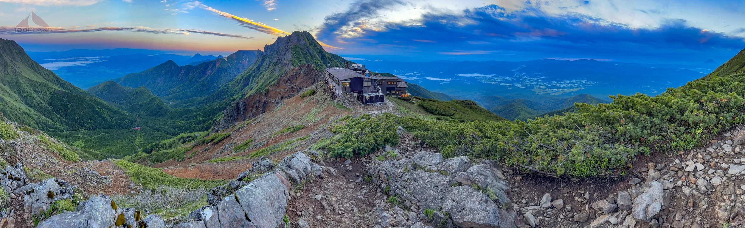
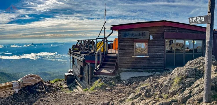
Akadake Tenbou-so at dawn
Yatsugatake Ridge rolled out to the north, impossibly narrow and steeply undulating at first, but rounding out as it continued into the distance. It was beautiful, but I was reassured in our decision not to attempt this during the 2-day storm.

Dawn Panoramic from Yatsugatake Ridge (Click to enlarge)
Behind me was the steep ascent up to Akadake. And peeking out from the edge of the ridge was Mount Fuji.
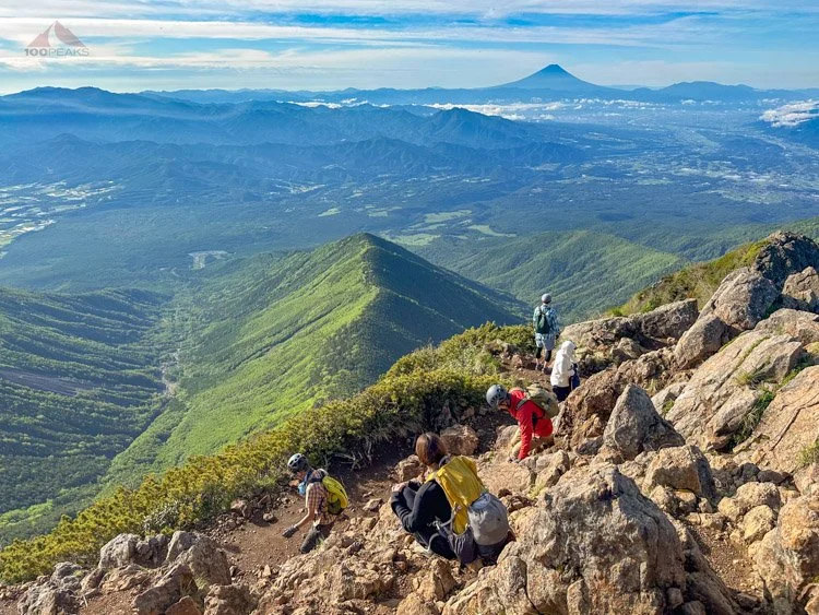
I was elated. I took picture after picture as the sun slowly rose. After 48 hours of whiteout conditions, I felt released from a white bubble. I could see for many miles in each direction. Reminiscent of my hikes in Hawaii, I was surrounded by sharp volcanic ridges covered in dense rainforest.
We all started chatting after a while, using the few Japanese words that I knew, and speaking English slowly. We were all amazed at the view and were grateful for the weather.
The wonderful morning view from Yatsugatake Ridge (Click to enlarge)
I stayed there for 40 minutes, briefly coming inside only to try to rouse Sophia, who could not be woken up. I let her sleep and jogged back up the ridge to continue to take in the view of a lifetime.
Later, back in the room, we packed our backpacks, including our prizes, and headed to the dining room for breakfast. Sophia asked me why I didn’t wake her up for the sunrise. I let her know that I had tried to no avail.
As I was packing, I found my leather coin purse that I had purchased in Takayama. It was packed full of Yen coins. I was only 20 yen (about 14 cents) short of being able to afford the Mount Akadake pin.
I approached the front desk to purchase the pin. I asked if I could somehow send them the remainder later. The owner walked up to me, translating through the staff, and offered me the pin and did not accept my remaining coins. He thanked me for staying three days and wished me luck on the way down.
I thanked him profusely for his hospitality and wished him a good season.
Sophia and I had breakfast and made our way outside to climb Mount Akadake before we were to descend back to the valley.
At the entrance to the hut, a group of people surrounded the emcee, who was dressed only in a traditional loincloth. It was quite a sight for a chilly morning.
He handed me a large wooden mallet and insisted that I take a few whacks at the mochi in the bucket. This is the traditional method of making mochi. I dropped my pack and gave it my best, whacking the mochi numerous times.
Once again, I was moved by how inclusive and hospitable this group was to us. We were outsiders and there was a clear language barrier. I had specifically chosen Yatsugatake Ridge, as it wasn’t as popular with tourists and westerners. I wanted a more “Japanese” experience, and I definitely wasn’t left wanting.

Making mochi at Akadake Tenbou-so
After a heartfelt goodbye to the staff and the other visitors, we headed up the steep ridge to Akadake.

The steep climb to Akadake
Yatsugatake Ridge from Akadake
Hearts pounding, we removed our layers and continued the steep climb, sometimes with chains, up to the top of Mount Akadake. There was another hut that wouldn’t be open until sometime in July.
We scrambled to the summit, sharing it with about a dozen people.

Chains are required

Getting closer to Akadake
We sat on the side of the summit, looking at the southern and eastern ridges, both potential entry points to Yatsugatake Ridge. Mount Fuji remained majestic in the distance. It was nice to be in the sun.
Akadake Summit Lodge
Enjoying the view to Mount Fuji from Akadake

The view of Mount Amida from Akadake
We started down the Bunzaburo Trail and were immediately met with a ladder to downclimb. The trail was very steep and rocky.
Perhaps it was our lack of experience on this loose type of trail, but the locals were nearly running down, while we were choosing our footing carefully. At times, we downclimbed some chains.

First downhill on the Bunzaburo Trail is to down-climb a ladder
During one humorous exchange, we came across some climbers on their way up, so we stepped to the side, saying “Dozo,” which is a word of welcoming.
What we thought was 8 climbers ended up being over 30, as an endless stream of “ohayo gozaimasu” and “arigato gozaimasu” (good morning and thank you very much) came from each and every one.
Today was a Sunday and it was a popular day for climbing, since the weather was finally good. We would be pausing to allow climbers to ascend throughout the rest of the day.
Continuing down the Bunzaburo Trail

The Bunzaburo Trail is very steep
Around 7:30AM, ohayo gozaimasu changed into konnichiwa from all of the climbers we passed.
We dropped about 1,700’ in .8 miles, steep by any measure. We were grateful to be at the Gyoja Goya hut again and took a break on the same picnic bench as before. This time, instead of having the place to ourselves, it was full of day hikers. To some, this was the end of their day’s journey, while others rested for the final steep climb to the top.

Back to Gyoja Goya for a rest, the ridge we came from above us

Gyoja Goya, still wet from the 2-day storm
We got going again, making good time on the flatter section along the riverbed, but often had to step aside to allow climbers to pass. The trail again descended into the rocky and rooty river gorge and we attempted to avoid mud, puddles, and very slick rocks.
We made it to the dirt road and were again hopeful we could snag a ride to skip past the road walking, but alas, everyone was on their way up.
We made it to Yatsugatake Sanso and had a cab pick us up and take us to the Chino train station, reversing our multi-train course to Kyoto.
We reflected on our trip. By now, we’ve come to accept that our trips don’t always work out as planned, but in some way, we always tend to have wonderful experiences.
The cultural exchange, the friendly people, and the perfect sunny morning with a view to Mount Fuji ended up making all of the time stuck in the hut completely worth it.

Happy to be in Japan

