


Mount Whitney from Horseshoe Meadows through Miter Basin - 26 years in the making
Mount Whitney
Dates hiked: July 7-10, 2010, returned for an attempt in 2020, succeeded in 2021, first time was in 1984
Total Miles: 33.42
Total Elevation Gain: 7,473 '
For those interested, here is a list of my gear that I have found works well for me. This is, of course, an affiliate link and your enjoyment of these may vary:
It’s been over a week since I’ve been back from the Sierra Nevada as I am writing this. I’d hate to wax poetic, but the landscapes that the PD and I hiked and scrambled through have permeated my thoughts, resonating within me each time I close my eyes.

Mount Whitney from the Lone Pine Visitor Center
The PD and I left San Diego Thursday at 4AM. Due to getting some work done and preparing for the trip, I was able to get to bed at 3AM. So, on one hour’s sleep, we avoided most of the traffic through Riverside and San Bernardino and were speeding over the rolling landscape of the 395 by the time the sun rose.
At almost exactly 8AM, we arrived at the southern end of Lone Pine. We stopped by the visitor center to pick up our permits and ask some questions about snow in the passes. The extremely helpful people at the center let us know that people had gone through all the passes on our route (New Army Pass, Crabtree Pass (we would question this one later), and the route up to Mount Whitney Summit Trail), and that all was clear. There would be no need for any special gear.
We had rented a bear canister at REI here in San Diego, so we didn’t need to rent one at the Visitor Center. It was slightly more expensive this way, but it was nice to be able to make sure all the food we needed was going to fit within the confines of the canister.
We were hungry, so we got the deluxe breakfast at McDs to fill our stomachs for the trek ahead. At this point, we called our shuttle driver, Dave Sheldon, a Lone Pine local, to meet us at Subway, where we were picking up sandwiches for the road. He was there in less than 5 minutes. It’s nice that he was that close. The other shuttles were coming from Mammoth, at 3-4 times the cost and would have to drive an hour or more each way.
He led us to Whitney Portal, where we dropped off our car and drove us to Horseshoe Meadows, where we were beginning our journey. He entertained us with stories of the town and his artwork and dropped us off at the trailhead, even taking our picture for us. I would hire him again in a heartbeat.
We met a couple who said they were going the same route as us and asked us when we were summiting Mount Whitney. We told them Saturday. They gasped. We grinned. The were doing it in 6 days. We were doing it in 3. We could do this. We had trained. We had many hours of daylight to cover these miles.
Wishing them luck and readying our packs, we set off up the trail. Ideally, we should have camped at Horseshoe Meadows to acclimatize ourselves to the over 10,000 feet of elevation, but we didn’t have the time to take off work at this point. We were gasping a little in the first 5-10 minutes, but soon got our rhythm. Our pace was so fast that a pack train behind us only caught up when we stopped to take pictures at a stream crossing.

At the Horseshoe Meadows Trailhead

Meadow near Golden Trout Camp

Crossing Cottonwood Creek

Crossing Cottonwood Creek Again
We felt good. We could do this. We were doing this.
We continued up the trail, passing meadows and a youth group with oversized packs and improper shoes. Luckily, they were only going as far as Cottonwood Lakes, since they looked worn out already. I had hoped they weren’t too tired to enjoy the scenery. Undoubtedly, the scenery and the experience was bound to change their lives.
At this point, we started noticing the mosquitoes appearing at every stream crossing, but they tended to disappear once we gained a little elevation above the streams. We came to a fork in the trail where we met two guys from Florida. They asked us if we were summiting Mount Langley.
We said: Nope, we were summiting Mount Whitney.
Them: When?
Us: Saturday.
Them: Yikes. We are just doing some day hiking around here before we actually attempt to summit Langley tomorrow. We wanted to acclimatize.
I can’t speak for the PD, but I was feeling so good that there was an inkling of an idea that we may even be able to summit Mount Whitney tomorrow. After all, the next day of our trip was only 5 miles. If we could somehow cover that distance today, we’d be within striking distance of Whitney.
It’s hilarious to write this, knowing what I know now.
We continued to hike on, crossing a stream on a log that looked like it was on its last leg. The mosquitoes got more aggressive, so I put on my Ex-Officio Buzz Off shirt, which kept them at bay for the most part. We kept gaining altitude, which surprised me, since the guidebook read that we were only gaining 1,100 feet in 6.5 miles. A stroll through the park. But that is net gain. We gained and lost elevation over the 6.5 miles, a total of about 2,500 feet of gain, but we still felt pretty good as we passed the Cottonwood Lakes and got to Long and High Lakes. We also started to have marmot sightings, our chubby, cute rodent friends that would keep us company throughout the remainder of the trek. At this point, I started missing the longer lens of my DSLR, but wasn’t missing the weight. We also saw plenty of trout in the shallows of the lakes and streams.

Cottonwood Lake #1 with Mount Langley in the Distance

Long Lake in Cottonwood Lakes Basin

Above Long Lake looking towards New Army Pass
We looked around the bowl we were in, searching for signs of New Army Pass, but could see no sign of where the trail was leading us. I’ve been in this position many years before at Colby Pass, several miles to the northwest, looking at what I thought was a box canyon, only to see tiny little people making their way up the side, and this was no different.
We saw a lone woman coming down the north side of the bowl, on our right. We assumed she was traveling cross-country, making her own way over a seldom-visited part of the area. Nope, she was coming down the trail where we would soon be going up.
We started up the long switchbacks that crisscross the side of New Army Pass. At this point, my head started pounding and my breath was harder to maintain than ever. My heart rate skyrocketed after every step and it seemed to take forever to get to the top. Halfway up, I looked back and was treated with an incredible view of the Cottonwood Lakes Basin, leading miles into the distance.
After crossing a precarious section of snow where my foot slipped and I grabbed for a large boulder for stabilization, slicing my finger, we staggered to the top of the pass. The elevation was about 12,300 feet or so. We were tired and gasping, but were far from being done for the day.

Above Long Lake with campsites in the trees

High Lake under new Army Pass

Cottonwood Lakes Basin from halfway up New Army Pass

Mount Langley from atop new Army Pass

Our route downward to Rock Creek from New Army Pass
It was cold and windy at the top and my first view was of uninviting snow-covered mountains leading off to the west as far as I could see. The sheer scale of the Sierra Nevada mountains was staggering. To the north was the sweeping saddle that led to Mount Langley’s slanted summit. We saw someone or a couple of people camped in the saddle between New Army Pass and Mount Langley. It seems like an exposed and barren place to sleep.
Looking westward, we saw the sun intermittently show itself and hide behind the high clouds. It was flirting with the idea of setting, so we immediately set off down the trail. We were tired, but grateful for some downhill sections of the trail after all that uphill. Be careful what you wish for, I’d say, since the downhill was steep on our already tired legs. We knew we had another 4-5 miles to go before we’d be able to call it a day. We would not be able to make it to within striking distance of Mount Whitney today.
As we descended, the snowy rockscape slowly turned into a rocky marshland riddled with streams. More often than not, and this would become a theme for the entire journey, we were hiking in streams.

Descending into Rock Creek Basin from New Army Pass
We could see the tree line beginning below us and Rock Creek Lake, shining in the distance. It was unusually beautiful, but the mosquitoes started coming out more in droves than before. Once we got to the trees, we were tempted to stop and make camp in the fading light, but we knew we only had a mile or so to get to Soldier Lake, so we pressed on.
The mosquitoes clouded our faces and flew into our mouths, eyes and noses. I had thought that the temperatures on this trip would be too cold for the mosquitoes, but I was sorely mistaken. We finally made it to Soldier Lake. We were spent and annoyed by the flying pests. I had a severe headache and the PD was nauseous. The PD set up the tent, while I crouched in a meadow, filtered water, and fended off the relentless bloodsuckers. I was not feeling well. It could have been fatigue, the altitude, or my one hour of sleep the night before.
We looked up the hill a bit to another family that was camped there. They were wearing shorts and could not be seen swatting at any mosquitoes. Feeling miserable and antisocial, we hurriedly made dinner, which was Mountain Home’s excellent Beef Stroganoff, stashed our bear canister in the bear locker, took some Tylenol, and immediately went to sleep.

Campsite above Lower Soldier Lake
The next morning, we woke up feeling much better. We had slept ten hours and had needed it. The mosquitoes were still a problem, but, since the weather was still cool, they weren’t as bad.
The sun hadn’t yet reached our little meadow when I got out of the tent and went to the stream to filter some water. The sun painted orange the granite cliffs on the far side of the meadow and worked its way downward towards where I sat. The mosquitoes came by en masse to say hello.
We had some breakfast, which included oatmeal, pop tarts, cup ‘o noodles, and coffee. We made Starbuck’s VIA for the first time and we drank it black. It was easily the best coffee I’d ever had while camping. It was also very light. Even at Costco, it was still pretty pricey at about $.60 per serving.
We were ready for the day. If we could just get rid of the increasing swarms of mosquitoes.
The family camped next to us had tried to be social to us the night before, but we hadn’t been in any condition to return the favor. Now that I was feeling better, I went over to say hello. They were visiting from the Carolinas and didn’t have maps of the area to the North, including Miter Basin and Upper Soldier Lake. I had an extra map and offered it to them. They off-handedly mentioned that the mosquitoes weren’t a problem at all. My eyes must have popped out of my head and I asked them if they were wearing DEET. They said they were and had an extra tube and offered it to us. I gladly accepted and thought it was a fair trade for the map.
We put a few dabs of DEET on our hands, faces, and clothes. Magically, the mosquitoes went away. We could see the area for what it was: a beautiful meadow valley at the foot of a lake. The world was great again. We had a great night’s sleep and were no longer blinded by the swarming pests. We thanked them profusely and we went our respective ways. The mosquitoes would no longer be a problem for the remainder of the trip. In addition, we didn’t see a single soul for the rest of the day.

Trail next to Lower Soldier Lake

Lower Soldier Lake Pano

Heading down towards Miter Basin
We hiked along the west side of Soldier Lake and climbed up a use trail to the pass above it. Right away, we were presented with an amazing view of Miter Basin and the towering giants lining either side. The trail along the eastern edge came and went, which was mostly the occasional cairn, until we made it to the bottom of the basin. Then an obvious trail led us slowly upward, following Rock Creek.
The area was beautiful. Water was flowing everywhere. The green meadows gave way to a tundra-like area. Marmots greeted us at every turn and we only saw the occasional boot print on the ground. We would lose the trail at times hiking over rocks, but the way was easy to see. We simply followed the basin roughly northward, heading towards Sky Blue Lake.
What my mind was trying to wrap itself around was, “Where was Crabtree Pass?” It was supposed to be the most difficult part of the day, and at 5 miles total, I thought it should have been in sight by now.

The Southern End of Miter Basin

Heading towards the Granite Giants of Miter Basin

The Sub Peaks of Mount Pickering in Miter Basin
As we approached the first real climb of the day, I started to get a sense how difficult this day might be. Another blog had mentioned how this portion of the trail was “the longest 5 miles we had ever hiked.” I was starting to realize why. We climbed the steep right side of the waterfall that was cascading ahead of us until we spied a trail on the left-hand side. We crossed the stream and scrambled up the rocks right next to the falls and were met with buffeting winds and a panoramic view of Sky Blue Lake.
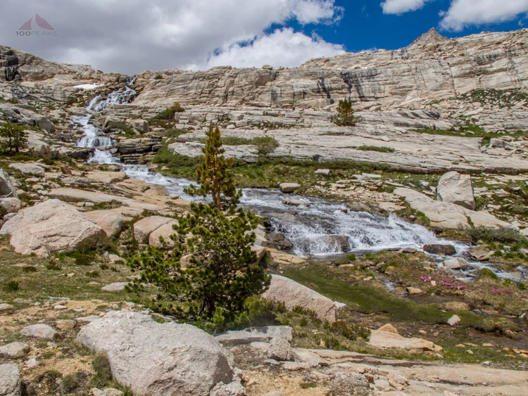
The Waterfalls below Sky Blue Lake

Sky Blue Lake Pano

Along Sky Blue Lake

The Choppy Waters of Sky Blue Lake, Looking South from where we came
We hopped over the top of the falls, not even considering until many days later that one slip could have sent us tumbling downward over multiple falls. We skirted the eastern edge of the lake and stopped to rest. We didn’t stay long, as there were many ants covering every area we could possibly put anything. Fearing ants crawling up our legs, we shouldered our packs and continued on. We reached the other side of the lake and began to climb next to the inlet stream. At some point a stream coming from the east would lead us to Lake 12K (what I will call this unnamed lake). I looked at Mount McAdie and the TOPO map and scouted around and pointed us to the east, following what I thought was a sure path to the higher lakes and, ultimately, Crabtree Pass. I eyed the cliff of granite ahead of us, warily wondering how in the heck we could get up that.
But that’s how I tend to feel about most passes. They look impassible until you get up close, and then the way appears. However, this sheer wall of rock in front of us could hide no trail. It simply wasn’t possible.
And it wasn’t.
Encountering two tarns at the foot of Mount McAdie showed me that we were at the wrong area. I had led us too far to the east. I wasn’t looking at Mount McAdie, but a lower shoulder of the granite giant. We had to backtrack to the west and find a way around the cliff and towering waterfall to the north.

Waterfall and Tarn above Sky Blue Lake

Heading up to Crabtree Pass, Mount Newcomb to the left

Looking back down to Sky Blue Lake
We made our way back and followed the main stream again until we started see other lakes. I stopped here, fearing we would go too far to the west. At this point, we pointed ourselves northward and eastward up and over a daunting ridge. Again, we saw the occasional boot print, but, like us, they might have been struggling to find a way through this trail-less rockscape.
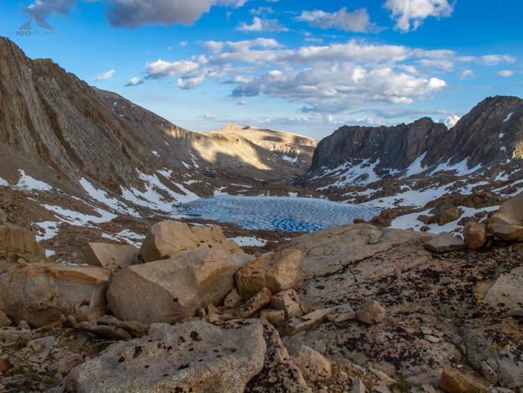
We finally found Lake 12K, but it was mostly frozen and the way we were supposed to have gone was completely covered by steep snow fields. We scratched our heads, surveyed the area and maps, and decided to follow a rocky ridge to the west of the lake. We had to climb over boulders and cross snow fields, all the while seeing the occasional cairn, but mostly forging our own path that lead left of center of the ridge to the north of Lake 12K.
Several hours later after zig-zagging all over the place, when we topped that ridge, we saw the last frozen tarn before Crabtree Pass. Consulting the topos and trying to avoid dangerous ice fields and impassible boulders, we crossed over to the east side of that lake and made our way around it, getting to the other side of the lake to the middle. We crossed a wide snow field and started bouldering steeply upward toward the top of the pass.

Almost to Lake 12K, Crabtree Pass up and to the left

Looking for a way to Crabtree Pass through the boulders

The mostly frozen Lake 12K

More navigation to the west of Lake 12K
We got to the top of the outcrop and realized we had to cross a steep snow field to get to the top of the pass. There were no footprints in any of the snow fields we had crossed that day to lead us in the right direction and this one was no different. Where was the sign of the others that had come before us?
Gingerly stepping on the snow, we made it to the top of Crabtree Pass. So much for our day of light hiking. It was now around 6PM and we had been hiking nearly non-stop for almost 9 hours. We weren’t even done yet. Two things made our jaws drop.
First, the way downward to Upper Crabtree Lake was a steep slope of loose scree. To fall would be to die, or at least severely injure oneself. Secondly, from the windy top of the Crabtree Pass, where we caught our breath, we looked ahead to our hike the next day. Incredulously, the PD had to keep asking me to clarify which way we were going tomorrow. I pointed to the near-vertical sandy and rocky avalanche monstrosity that loomed above us on the other side of the lake, which itself lay far below us. “Where is Discovery Pinnacle?” he asked. I wasn’t 100% sure, since it didn’t look real. The immensity of the task ahead made us doubt what we were seeing on the map and what lay so far above us.
I pointed to it, but Discovery Pinnacle looked so high up and so distant. Tomorrow, where we were supposed to climb a sandy slope and pop over to the Mount Whitney Trail, looked to be the most difficult thing I would ever do. There was no trail. Nothing told us where to go, except the existence of steep snow fields that would ultimately funnel us through the rocks and talus to the slightly less steep second half of the climb.
Accepting our fate, we gingerly made our way down the loose slope to the head of Upper Crabtree Lake. We saw some interesting scat and prints that looked canine or feline. What animal would live up here and cross that treacherous pass?

Snow just before Crabtree Pass
Looking back to Lake 12K from Crabtree Pass

Heading down the other side of Crabtree Pass to Upper Crabtree Lake

Looking down the valley from halfway down Crabtree Pass
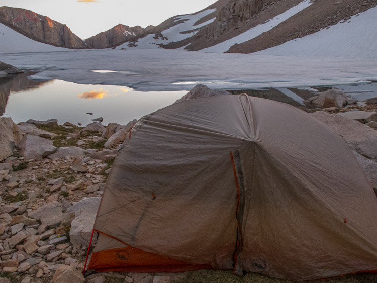
There was one campsite, exactly the same size as the footprint of our tent. One tent peg was actually staked into a small stream. There were too much snow and boulders to camp anywhere else. Once again, the sun was going down and the temperature was plummeting. We filtered water and made dinner and pitched our tent.
We did, however, treat ourselves with some Super-Tuscan Wine. It warmed my insides as I looked out over the shining silver lake with blankets of ice, rocks, and snow lining the valley walls. It was stunningly gorgeous.
We were tired of hiking all day, two days in a row. I was winded at the slightest effort. My appetite was low, but the Mountain Home meals were many times tastier than they were when I was a kid. Every afternoon, the clouds would threaten us at about 1PM, but nothing would come of it.
We made the best of our situation, but our subconscious minds were undoubtedly on the steep hill that loomed both physically and figuratively above us. Even though it was very cold outside, we were hot in our tent that night. We had both been exposed to many hours of high winds and sun that even sunscreen couldn’t protect us from.
After a day of hiking, where 5 miles (“an easy hike through moderate terrain,” read the guidebook) turned into 7.6 miles, it rained, hailed and sleeted throughout the night, and we didn’t really get to sleep until the early hours of morning. The occasional avalanche or rockfall down the valley crackled and rumbled, reminding us where we were going the next day. Exhausted as we were, something prevented us from sleeping.
Barely room for our tent

Upper Crabtree Lake

The wall of scree that would take us hours to climb
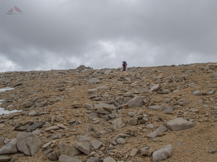
We woke up, still a little tired from the day before and packed up. There was nothing to do except carry as much water as possible and get up that slope, one step at a time.
It turns out some of those steps had to be repeated, since we would slip down the sandy slope at times. After about 3.5 hours of grinding mountaineering, navigating around snow fields and boulders, and sucking air, which really under-describes the experience, we made it just to the right of Discovery Pinnacle. We leaned over the edge to the north and could see the Mount Whitney Trail below. An actual trail! And people! It had seemed like weeks since we had seen people, even though it had been a little over 24 hours.

Halfway up the scree wall, Lake 12K and Mount Langley in the distance
Scrambling up the scree slope, with Discovery Pinnacle peeking over the edge to the left

Our first view of Mount Whitney from Discovery Pinnacle, you can just make out the summit hut

The way to Whitney Portal from Discovery Pinnacle, we will drop over 6,600' before we get to rest today
Again, we were presented with going down a dangerously loose and steep slope. This time there were people below. The PD went first, nearly braining an unsuspecting hiker with a tumbling rock. I am sure we were at the last place anyone would look up. “Where the heck did they come from?” they probably asked themselves. As we slid on our butts down to the Mount Whitney Trail, we could see what looked like an endless procession of zombie-like hikers, making their way to the highest point in the continental United States.
Once we hit the trail, I was elated. I felt strong, even though the last 3.5 hours of scrambling had taken a toll. I was on a trail, I was acclimated to the altitude as well as could be, and I was ready to drop my heavy pack and slip on my light summiting pack and go for it.
We stopped for a snack and started our way to the summit. The first third of the trail, I was practically jogging. I was passing huffing climbers left and right. I had my rhythm and felt good. The PD and I stopped for a second to take a picture and then I hit my wall. I am not sure if the trail suddenly got steeper, or I lost my mojo, but the hiking became more difficult and my breathing more labored. I was still passing hikers, some of whom I would never see again. They must have been turned around by the ranger, who was warning everyone about the very real danger of lightning, or simply had had enough.

A peek through the window

Getting closer to Mount Whitney

Getting closer, running out of steam and air

Looking down to Guitar and Hitchcock Lakes
It hailed on us off and on for about 4 hours, the duration of our time on the upper area of the mountain. I started seeing people on their way down, telling me I was almost there. Once approaching the summit hut, I started to get emotional and nostalgic.
26 years. This mountain has been a part of my existence for 26 years. Once you’ve been here, it gets inside you. You can’t shake it. You become one of two people; someone who hasn’t summitted Mount Whitney, or someone who has.

My dad and I atop Mount Whitney in 1984
Mount Whitney was one of those places that I thought I would never see again. All it took was a rejuvenation of my fitness, a desire to climb it, the foresight to get a permit, and the resolve to put it on the calendar.
On Wednesday, I was sitting in my office at work. On Saturday, I was on top of the Sierra Nevada. I was elated and overcome. Thoughts and emotions swirled around. I thought about the picture of me from 1984, 12 years old, where I looked like a little old lady in my oversized yellow windbreaker and oversized black beanie, all hand-me-downs, except my Bermuda shorts.
I had done it then, as a follower. I had done it now, as an adult and trip planner. I had chosen the path, read the topos, and got us here. This one was mine. And mine to share with the PD, who had long ago become like a brother.
We shared a brief moment on the peak, my achievement slightly undermined by a Latvian in Vans and a track suit that jogged to the top right after us, hardly out of breath and carrying no water. We took some pictures for him and vice versa. By the time we started on our way down, he was nowhere to be seen.

Back again at the Mount Whitney hut, so many years later
We made great time on the way down, until the uphill section started. Luckily, it was short-lived and we were soon back to Trail Crest. We were tired. We had seen so much and our feet had covered so much ground, but we still had to get off the mountain. We started down the infamous “99 Switchbacks.” I had a great rhythm. I was practically running down them, even though many of them were streambeds.
We got to the Trail Camp at about 6:00. We asked a group from Loma Linda that we had met earlier if they had any extra water, since we were running low on fluids and sunlight. We couldn’t use precious daylight for filtering if we could avoid it. They gladly gave us almost 2 liters, since they were mere footsteps from their campsite. We also asked around and were told we could make it to the bottom in about 2 hours. We were hopeful to make it to our car before dark.
We set off, and once again, the trail was harder than anticipated. There were so many tall steps in the trail and my knees were worn out from the switchbacks above. We dropped into beautiful valleys and crossed gorgeous alpine rivers. Mirror Lake was a memorable blur as we raced the sun. It was about 7:30 when we reached Outpost Camp. We had gone 3 miles in an hour and a half. Only 2 miles an hour? We were trudging quickly down the mountain, but somehow not making any progress. We continued on as the light began to fail. We still had 4 miles to go. We switched on our headlamps at about 9PM. We had been able to see the road in the distance for a while now, but it didn’t seem to be getting any closer.
At 9:45PM, we turned a corner and saw the wooden structure that frames the way in and out of the Mount Whitney Trail. We staggered to our car and congratulated each other. We had made it. It was one of the longest hiking days in my life. We took hardly any breaks and still managed to hike over 12 hours.
We ate at McDonalds in Lone Pine, as the Whitney Portal Store had closed long before, and then made our way south. We stayed at a hotel in Palmdale, as the PD’s daughter was in a tournament and there was no way I could drive back to San Diego that night.
I got to bed at 2AM and was woken at 7AM by eager softball players and then I went back to sleep until 10AM. I lounged for a while and checked out of the hotel, grabbing some lunch and headed home. Once home, I immediately went to sleep for about 5 minutes until the family started calling. They were coming over and then we went to Soup Plantation. It hit the spot, but I was spent.
At work on Monday, I was lethargic, still dehydrated, and coming down from the adrenaline rush. It wasn’t until Tuesday that I started feeling better, but it’s still hard to adapt to normal life after experiencing landscapes like this. It gets in you and changes you. Stuff that used to stress me out seemed dull and mundane. No worries, mate.
I am now already thinking about my next trip into the Sierra. More days. Fewer daily miles. Fishing, layover days. I’d like to enjoy the landscape more, rather than see it as an obstacle to be scaled.
The Sierra Nevada has been calling to me for over two decades. Although the trek was difficult, it was truly beautiful. I am glad I answered the call.
What I learned:
- Don’t get Subway’s Spicy Italian Sandwich for the road, you’ll taste it in the miles ahead.
- Deet works well.
- Goggle-like sunglasses would have protected my eyes better. They were red and burning at the end of every day, blurring my vision for the last couple of hours.
- Distances feel so much greater in the Sierra; plan on more days.
- People on the trail are some of the nicest people I've met.
- Locking trekking poles work better than twist-to-tighten poles in tougher situations.
Maps

Map Day 1: Horseshoe Meadows to Lower Soldier Lake over New Army Pass
Map Day 2: Lower Soldier Lake to Upper Crabtree Lake
Map Day 3: Upper Crabtree Lake to Discovery Pinnacle to Trail Crest
Map Day 3b: Trail Crest to Mount Whitney iPhone battery drain
