


Bonny and White Benchmarks - Peaks 55 and 56 - On the edge of Anza-Borrego Desert SP

Sunrise over Anza Borrego Desert State Park
Bonny Benchmark
Elevation: 4,574'
Dates Hiked: 02/25/2011, 04/10/2011
Peakbagger.com Page
White Benchmark
Elevation: 5,326′
Dates Hiked: 02/25/2011, 04/10/2011
Peakbagger.com Page
Total Mileage: 5.26
Trailhead: Turnout on north side of road, just east of Ranchita
Agency: Anza-Borrego Desert State Park
For those interested, here is a list of my gear that I have found works well for me. This is, of course, an affiliate link and your enjoyment of these may vary:
02/25/2011
Sometimes the stars align and everything makes for a perfect hiking day. This was not one of those times. Granted, any day of hiking is better than doing almost anything else, but some conditions can be more challenging than others.
We got an early 4AM start. When I say “we” I mean the friends I will refer to as the She-wolf and Level 3. I’ve hiked with them before, on my trip to Villager and Rabbit Peaks. I was kicking around the idea of squeezing a hike in before I would have my daughter (Sophia) solo for about 2 weeks while my wife (Hoa) travels for business.
I mentioned taking a day off work to Level 3 and he asked if I wouldn’t mind if he came along. That sealed it. We had a plan and were going with it. Leading up to the day of hiking, I looked at the weather several times a day, and all signs said that all hell would break loose over San Diego on Friday afternoon.
We decided to get an early start. 4AM is pretty early, even for me, even when excited about hiking, which I was. We drove through Ramona in the dark, searching for someplace to get some pre-dawn breakfast. Jack-in-the-Box did the trick and we took a left in Santa Ysabel and continued north past Lake Henshaw.
Just as we got to the “trailhead,” the sun rose over Borrego-Springs. The wind buffeted us as we got our gear together. I was already getting some misgivings. It was 40 degrees F, and it was hard to stay on our feet from the heavy gusts. I was certain we would warm up shortly, but I had a feeling the winds would get worse before they got better.
I use the term “trailhead” in quotation marks, since there really wasn’t a trail heading to where we were going.
We set off through the desert, avoiding the abundant cholla cacti that were growing everywhere. It seemed every game trail squeezed as close as it could to the spiky hazards. Right away, we noticed the tracks all over the ground. I initially though they were deer, but the scat told us that it was big-horned sheep.
The sheep had been everywhere, and their sign would follow us for the entire hike, but the animals themselves remained hidden. They had likely gone to lower elevations to get out of the wind.

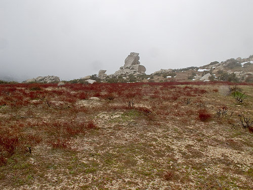
Bonny Benchmark from the north

White Benchmark from the Bonny Benchmark summit
In no time at all, we got to Bonny Benchmark, a small peak that is on the San Diego Chapter of the Sierra Club’s One-hundred Peaks Section, as is White Benchmark. My intent of the day was to summit four (possibly five?) peaks in one epic trek through the desert.
Climbing to the top of the summit block on Bonny Benchmark, I was nearly blown off. Concerned about keeping my fingers (it was cold!), I didn’t sign the register, but simply took a few quick pictures. I dropped down out of the wind a bit to shoot my video.
From here, we could see White Benchmark, the next peak on my list. The trail-less slope to the peak looked pretty steep, but thankfully not too choked with brush. We dropped into a little wash to get shelter from the wind and continued north. We could see the drama of a deer getting chased by a mountain lion play out before us in the tracks in the dirt and snow.
The snow was just a little patchy now and it was difficult to know how much lay before us. As we ascended, the clouds dropped toward us. The clouds and we met each other in a clash of freezing mist and high wind on the southern slope of White Benchmark. The bushes were covered in a layer of rime ice. If we stayed there long enough, we would be, too.

Ice on the bushes on the slope of White Benchmark

The view south from the slope of White Benchmark
It was at this point that I started wondering if continuing past White BM would be a wise thing to do. There were several things working against us:
I couldn’t see any landmarks in the distance, much less the peaks to which we were heading. I had my maps and my GPS, and a rough idea of where to go, but continuing on blindly would likely be time-consuming and potentially dangerous
The cloud level kept dropping, obscuring even more visibility
The temperature felt as if it was dropping, rather than increasing, as most days do
Travelling cross-country was taking more time that I had anticipated. I also hadn’t gotten very much sleep the night before, so my speed wasn’t very fast
The amount of snow on the ground was increasing in density and depth. At times, I would sink up to my shins in a particular drift. This would also slow our progress and create risk of injury.
The wind felt like it was picking up even more
The sky could open up on us at any time
Once we got to the top, there wouldn’t be any view
There is always the very real danger of lightning

The view from White Benchmark

Hellhole Canyon below the clouds from White Benchmark
We decided to continue on for a little bit to see how it went.
From White, we couldn’t see The Thimble, which was our next destination, but we headed in the general direction. We had to bushwhack here and there and the snow got thicker and we had to drop to a saddle before we started over another.
We wound around brush and boulders until we were surrounded in fog. I looked at my watch. 10AM. It took us 4 hours to go 2.6+ miles, and we were only half-way to San Ysidro Mountain. It didn’t look like it was getting any easier.
I made the call: Not worth it.
We turned around and skirted the eastern site of White BM and dropped back down the steep slope to lower ground, all the while staggering from the winds coming from the west.
We chatted about all sorts of stuff, while I navigated, making sure we weren’t too far off track.
We saw a jawbone on the side of White Benchmark. We got pretty close to Chimney Rock, which looked to have permanent ropes dangling in the breeze. Since we didn’t have to summit Bonny on the way back, I made a beeline for the car, which brought us pretty close to border of Anza-Borrego Desert State Park and the properties that abut the fence line. In reality, I was hopping from game trail to game trail, meandering all over the desert to avoid entering private property and hitting cacti.

Jawbone
Chimney Rock

The trail through the cactus
We made it back to the car and got inside to warm up a bit. My face took about half an hour to thaw out. The temperature at the car had dropped to 37F. It was colder up on the mountain and the wind chill was significant.
It was getting colder. As we drove off, sprinkles started hitting the windshield.
Although there was some remorse about choosing to pull the rip cord on a challenging hike, I knew my decision to turn around was rational and the right one to make.
We had bison burgers at the restaurant in Santa Ysabel and talked about how nice it was to sit in a booth and not be trapped in a downpour or whiteout.
With experience comes wisdom, and I feel that this type of wisdom will prevent a potentially dangerous situation and increase the enjoyment of the outdoors. Although it might be exciting to get airlifted out by a search and rescue team…
I’m totally kidding, OK?
Live to hike another day, I say.
Update: I came back to summit all four peaks on the ridgeline a few weeks later.
Bonny and White Benchmarks Trail Map (Click to enlarge)