


Mount Whitney Backpacking Trip 2020 – It’s About the Journey, Not the Summit
This Mount Whitney backpacking trip explored the beauty of California’s Sierra Nevada while reinforcing an important lesson of wilderness travel: sometimes the experience matters more than reaching the summit itself. This trip follows a scenic high-country journey through alpine lakes, granite basins, and mountain passes surrounding Mount Whitney, where changing conditions and time spent in the landscape became more meaningful than standing on the highest point in the contiguous United States.
Mount Whitney
Elevation: 14,505
Route: Horseshoe Meadow to Mount Whitney via Cottonwood Pass
Nights on Trail: 4
Miles: ~33
Shuttle: East Side Sierra Shuttle (Great!)
Trailhead: Cottonwood Pass Trailhead
Agency: Inyo National Forest
Date Hiked: 08/10/2020 to 08/16/2020
Peakbagger.com Page
For those interested, here is a list of my gear that I have found works well for me. This is, of course, an affiliate link and your enjoyment of these may vary:
Background
Throughout her childhood, my daughter, Sophia, has heard the stories of my adventures. She has seen the photos of me in Sequoia as a young boy and canoeing down the Colorado with the Boy Scouts. She has seen my more recent adventures since I started blogging in 2009. She even has been part of many of these.
But one adventure has stood out among the rest, for both me and her: My 9-day trip to Mount Whitney when I was 12. For years, Sophia has been planning on also summiting Mount Whitney when she was 12, just like her father. In the spirit of this, we started planning for this trip in 2018, but talked about it long before that.


For the past two summers, Sophia and I have been making trips to the Sierra, including two trips to the Treasure Lakes and Long Lake from South Lake outside of Bishop. She’s been testing her gear and honing her Sierra backpacking skills and keeps asking for more days in the backcountry.
In February of this year (2020), I was able to secure some permits for the summit of Mount Whitney by going online to recreation.gov and getting some permits for two people, 6 months in advance. It wasn’t very difficult, as only the permits to go up the front of Mount Whitney from Whitney Portal are hard to get via the lottery. This I will never do.
With months to train and get ready, we were confident that the trip wouldn’t be a problem.
Then COVID-19 hit and everything closed down. My restaurant, Burger Bench, had to pivot our processes numerous times, keeping me busy and stressed out, resulting in very little time for training. I was concerned about the mental well-being of my daughter while navigating a global pandemic.
While many people I knew were blasting through their streaming queues, I was working longer hours than I had in years and losing sleep worrying over the new and changing regulations, as well as the safety and well-being of our employees and customers.
August snuck up on us and we packed up our gear and headed north to the Eastern Sierra.

In the car and ready to go
Our plan was to stay one night in Lone Pine, then hike to Chicken Spring Lake over Cottonwood Pass to Rock Creek, Crabtree Meadow, Guitar Lake, Mount Whitney, to either Trail Camp or Outpost Camp and then head out.

The view from our rental in Lone Pine
Day One: Horseshoe Meadow Overnight
After staying a night in Lone Pine, we got up to Horseshoe Meadow. We had arranged a shuttle to pick us up at Whitney Portal and take us across to our starting point.

Breakfast at the Horseshoe Meadow Trailhead
Soph was understandably considerably nervous about heading into the mountains, as we headed toward Chicken Spring Lake. This was to be her longest time away from home in the backcountry.

On the trail from Horseshoe Meadow
After some lengthy discussions, we called it a training hike, going about 2 miles out and turning back, rather than making it all the way to Chicken Spring Lake, for a 4 mile day at 10,000’. We worked out some kinks with her gear and went back to Horseshoe Meadow to add an extra camp for the night.

The trail through the trees
After some adjustments and GPS communication with my wife, we settled in for the night.
As I was falling asleep, I did a mental inventory of our food, since we just added an unexpected day to our trip.
Day Two: Horseshoe Meadow to Chicken Spring Lake - 4.2 Miles
On day two, we woke up and took our time getting ready, Chicken Spring Lake is only about 4.2 miles away from Horseshoe Meadow, and only the second half was really a climb. We double-checked our gear and got packed up. We loaded up our water at the campsite and used the facilities.

Horseshoe Meadow

Crossing Cottonwood Creek
We headed out onto the trail, which was pretty sandy for the first half. However, Sophia did great, moving quickly up Cottonwood Pass, shedding off any trepidation she had the day before.

Climbing up to Cottonwood Pass
“I am so glad we’re doing this, dad”
My memory of Chicken Spring Lake from my trip in 2013 was that once we got to the pass, it was going to be downhill to the lake, which is not true. Sophia was disappointed and hit a wall as we could feel the wind kicking up as we gained elevation in the last mile to the lake.

Horseshoe Meadow from near the top of Cottonwood Pass
We briefly had service at Cottonwood Pass, so we took a quick selfie and sent it to my wife. We made our way to the east side of the lake, chatting with the Rock Creek Pack Station crew along the way. They were taking a group of people for two weeks along the John Muir Trail. We’d see them again on the trail and at Guitar Lake.
We dropped our bags and sat by the lake. Sophia was a little homesick and I was feeling that feeling when I came down from Mount Langley a few years ago. My mood was low and I had no appetite. I wanted to take a dip into the lake as a mood elevator, but the icy wind was blowing too hard.
Here I was in this beautiful setting and I didn’t want to be there. I wasn’t enjoying myself. This would happen several times on this trip. I wasn’t sure what was going on.
We decided to move our stuff to a different campsite up the hill, snuggled in between a huge boulder and a juniper, which turned out to be a great idea. We had some shade during the day and there was plenty of shelter from the gusting wind.
We then took a walk halfway around the lake to a beach on the north side. We sat on the edge and any thoughts of having a swim disappeared as the cold wind got even stronger. Sophia noticed my mood and succeeded in cheering me up with some kind words. She was a little homesick, too, so we did what we could to make each other feel better.

Enjoying Chicken Spring Lake
We went back and had some dinner up the hill, well away from our campsite, as we had seen bear tracks all over the place.

Ancient Tree near our campsite at Chicken Spring Lake
We settled into our tent and tried to get some sleep, but the winds howled all night, rippling our tent and making the guy lines sing. The wind only quieted once the sun started rising. We did not sleep very well.

The last sunlight at Chicken Spring Lake
Day Three: Chicken Spring Lake to Rock Creek 9.5 Miles

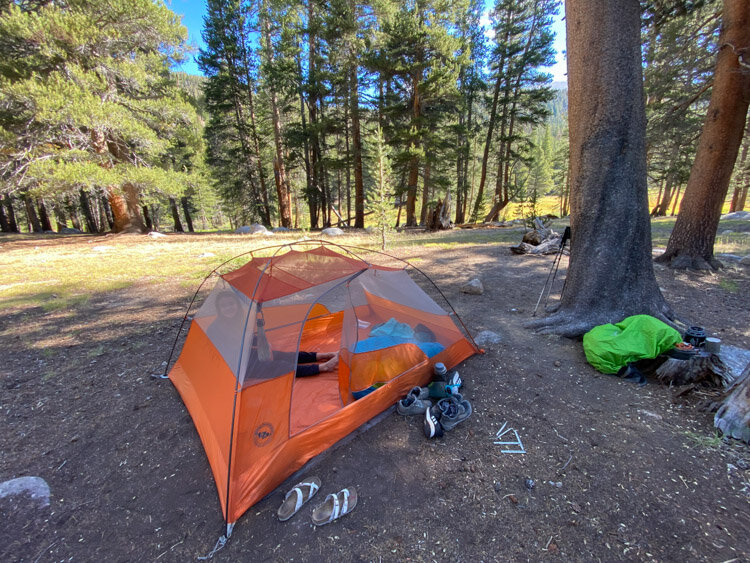
Our tent at Chicken Spring Lake
We woke up feeling groggy but good, and packed up in the chilly morning. The strong winds seemed to have passed.

Morning at Chicken Spring Lake
Back on the trail, we headed up to the ridge west above the lake. At this point, the pack train passed us, right at about the same spot they did back in 2013 on our day hike from the lake.

Looking down to Big Whitney Meadow from the ridge above Chicken Spring Lake
I asked the lead if she was expecting weather today, and she said, “It’s not unlikely” which seemed just about right as I could see the clouds around us. I had visions of our very rainy 2013 trip and encouraged Soph to continue on.
We stopped for regular snacks, while in the back of my mind, I was worried that we wouldn’t have enough food for the four nights ahead of us. I started to subconsciously ration food for myself while making sure Soph had enough.
We hit the last of the uphill as we entered Sequoia National Park. It was nice to have some downhill and flat trail for a while and would have it for most of the day. We cruised right along, as we encountered sprinkles here and there, but nothing major.

Siberian Outpost from the trail
I went to charge my phone, since Sophia was craving regular contact with her mother through the GPS, which was using my phone’s battery. I pulled out my lightning cable and realized that the other side was USB-C, which did not connect to my battery. I had brought the wrong cable, and we still had 3-4 days left on the trail.
We occasionally passed hikers, but it was easy to step off the trail to remain socially distant. We made great time. It was at this point that I noticed on the map that Rock Creek is a long area and my estimate of 8.5 miles for the day was closer to 9.5 or greater, since that campsite wasn’t at the first point where the trail met Rock Creek, but further down.
Another backpacker was resting on a rock near us. He had a solar setup on his pack, so I surmised that he might have the cable I needed to charge my phone. He did, and we struck up a conversation while I charged my phone.
His name was TJ and he was on a trip with three other people and they were headed toward Onion Valley. They were looking for a place to camp for the night since they had had a long day. We let them know that Rock Creek was four miles away and had plenty of water. As other members arrived, they decided to stay the night up there. I am assuming they had plenty of water, since there were no sources around.
Soph and I were both feeling a little tired, and were ready to stop for the day, but we needed to get to Rock Creek.

The meadow around Rock Creek
About a mile from camp, we sat and had a snack, and I had to encourage Sophia to finish the day. After seeing some mule deer grazing in the meadows around us, we arrived in camp, and it was actually nice to have people in campsites around us. The sounds of people followed us to the creek, where we soaked our feet and relaxed. I started getting a major headache that would pound whenever I exerted myself.

Rock Creek
The creek was nice, but my headache was intense and affecting my ability to think and communicate. Sophia stepped up and helped me filter water and get dinner ready. In all actuality, I was likely dehydrated and very low on calories, with some major lack of sleep. It’s also possible that, even though we dropped almost 2,000 feet since the morning, that the elevation was affecting me.
After dinner and some ibuprofen and benadryl, we headed into bed. It was about 8PM when I said I wanted to rest my eyes and I turned off the lantern. We woke up the next morning at 6AM.
Day Four: Rock Creek to Crabtree Meadows - 6.5 Miles

Morning light from the meadow at Rock Creek Campground
Last ones at the campground at Rock Creek
We woke up after ten hours of sleep, feeling refreshed and happy to have had a great night’s sleep. We felt great.
Once we emerged from our tent, we noticed that all but one group had already packed up and had gone down the trail.
We’d have to start getting up earlier, especially if we wanted to avoid potential weather.
We did have a wonderful morning along Rock Creek and the meadow, though.

Mule Deer near our campsite at Rock Creek

Crossing Rock Creek up toward Guyot Pass
We headed out onto the trail, crossed the lovely Rock Creek, and headed up the steep hill toward Guyot Creek, where we stopped and had a snack.
I had thought this might have been a campsite possibility for us instead of Rock Creek the night before, but this was a pretty decent climb to have done at the end of the long day before. There were some great spots near the creek and it would have been a great place to stay the night.
I mentally put it down on my list of places to come back to. We passed a couple who had camped there earlier on their trip and were heading back there for the night. They said it was wonderful.

Our nice lunch spot at Guyot Creek
We enjoyed our time at Guyot Creek, watching the ground squirrels hop from rock to rock, seeing if we had dropped any crumbs. We headed back on the trail and started up Guyot Pass, which is short, but steep, and just under 11,000’.
Near the top of the pass, I started feeling the elevation again, as I had to stop after every switchback to get my heart rate back down. We got to the top and had a short break, feeling good about getting over the biggest series of climbs for the day.

Guyot Flat with Mount Guyot behind
Before long, we were hiking quickly downhill, enjoying the view of the sand flats to our left and generally appreciating the rolling hike. We met the ranger of the area and she asked my name to check our permit later and let us know we could pick up wag bags at the ranger station at Crabtree the next morning.

Looking to the west to Red Spur and Kaweah Ridge across Kern Canyon, rain is on its way

Coming down to Crabtree Meadow with Mount Russell in the distance
We felt strong and made great time until the trail started uphill again to a small pass just before the drop to Crabtree Meadow. We passed around a gate and made it to the meadow.

Just a few hundred feet to our campsite at Crabtree Meadow
We saw TJ again, waiting for his party members, and he was considering hiking Mount Whitney the next day from Crabtree. I let him know that it’s a pretty intense climb, as he was hoping to summit it from Crabtree, return to Crabtree, and then hike an additional 10 miles that day. I told him it could be done, but it would hurt and there would likely be weather.
I was tired. More tired than I should have been. We set up the tent right away, much to the dismay of my daughter, who wanted to hang out at nearby Whitney Creek ASAP. My urgency was rewarded when it started raining on us right after the tent was set up. After an hour or so, the rain let up and we went to the creek to enjoy the ambiance.
We hung out at the creek for hours and had a great time, washing our clothes and hanging them to dry, filtering water, washing up, soaking our feet, and having dinner.
It’s these little moments together at camp that really make our trips so special. My time with my daughter is precious, and these uninterrupted hours of enjoyment by a creek or lake or whatever is around us in the outdoors are really what I treasure.

Sunset at Crabtree Meadow, Mount Whitney in the right rear
The sun never fully came out again at the creek, so we rehung our clothes near the campsite. The sun briefly came out over the meadow so we walked over for some photos and walked up the granite slabs above us to enjoy the last few moments of the day. We could see tomorrow’s destination high above us.

The last rays of the day at the slabs above Crabtree Meadow
We slept well.
Day Five: Crabtree Meadow to Guitar Lake - 3.5 Miles (probably more like 5.5)

Our tent at Crabtree Meadow
We woke up to a sunny morning, rehanging our wet clothes once again. This time, they dried immediately.
This was intended to be our short rest day before our summit attempt, but since we picked the southernmost campsite the day before and made a side trip to the Crabtree Ranger Station, we definitely added mileage onto our day.

Heading up the John Muir Trail along the northern end of Crabtree Meadow
We made our way uphill along the meadow until the turnoff to the ranger station. We headed up onto a big mesa and had a nice chat with the ranger we had met before. We picked up our wag bags and headed across the meadow to look for the pit toilet that I had read about. Nowhere online was I able to find a source that definitively stated where the toilet was.
There is a large campground area where Sophia and I had a snack and a rest.
Crabtree Meadow Pit Toilet Map (Click to Enlarge)
Crabtree Meadow Pit Toilet Directions:
Go southwest at the junction between the John Muir Trail and the Crabtree Ranger Station. Once you are at the mesa above Whitney Creek, there will be a bear box and a meadow in front of you. The trail to the ranger cabin continues to your left and a use trail will be leading across the meadow south in front of you. After you cross the meadow, you will come to a ton of campsites among the trees. At the very southwest end of these campsites, on the edge of the meadow way to your right, there will be a pit toilet open to the sky, with some corrugated steel on one edge, but not much privacy on the other. Totally worth it.

Climbing higher toward Mount Whitney, at center left rear
After our long rest, we continued past Timberline Lake, a very nice spot to stop and have lunch, which is what we did. We saw some day-hikers fishing in the lake and figured they were camped above or below us somewhere.

The lovely Timberline Lake
We continued above the treeline until we could see Guitar Lake. We saw a large camp to the left that was clearly the Rock Creek Pack Station group, with their large camp chairs and other non-backpacking amenities. I was ready to find a campsite, so we searched along the edge of the lake for a nice spot, rather than looking for a spot at the tarn above Guitar Lake and additional climb.

We found a perfect spot on the sand next to the large rocky hill next to the lake. We set up our tent and headed to the edge of the lake. Once again my mood was low. I couldn’t quite put my finger on it.

Our hangout spot at Guitar Lake
The day was warm while the sun was out, but quickly cooled whenever we were shaded by the clouds. We soaked our feet at the edge of the lake until I was ready to wade into it. Other people jumped in further down the lake with a loud “Whoo!”, but I waded into my waist and splashed the water all around. It was a little cold for complete submersion.
I sat in the sun on the bank of the lake and started drying out. I felt a lot better. I changed into some shorts and new clothes and felt like a new person. I ate some food and checked our bear canisters. By the next evening, we would be out of food. Tonight was our last full dinner and the rest was dried fruit and snacks. We would survive on a normal day, but we had some serious work to do the next day and I was concerned about total calories. We could either find some food for tomorrow night now or wait until wherever we’d camp tomorrow night.
I noticed a group next to us had arrived into camp. They had 4-5 people and were talking about having climbed Mount Whitney that day. It’s possible they may have some extra food so I asked them if they had any extra.
They glanced at Sophia and asked, “You’re out of food?” No, I said, we’re fine for today and most of tomorrow, but we’re running low.” A woman gave us some bars, which was very kind. I also was able to borrow another cable to charge my phone back up to 90%.

Feeling great at Guitar Lake
After that, we sat on a rock in fresh clothes, snacking. I was relaxed and feeling myself again.
Perhaps it was the anxiety of the climb the next day, or repeatedly counting our meals and snacks, worrying about the comfort and safety of my daughter, worrying about the daily storms that were coming in, or mainly the fact that I was rationing food for myself, but something kept creeping into my enjoyment of this trip.

Our tent at Guitar Lake with tomorrow's climb ahead of us
For the moment, however, I was content and enjoying our spot next to Guitar Lake, feeling clean and dry, with the granite giants on one side and the steep drop-off to Kern Canyon on the other. It was so gorgeous that it was hard not to be buoyed by it.

The storm will be here soon and rage for 4.5 hours
At 4PM, the black clouds above us finally could no longer hold their water and the sky opened up, sending hailstones, sheets of rain, high winds, lightning, and thunder our way.
We got into the tent and stayed in there for four and a half hours as the thunderstorms would pass to the north, only to start again with flashes and booming from the south and pass directly over us.
We played countless games of rummy as we chatted with my wife back home over the GPS, whose weather report indicated that there was only 5% chance of rain at our location.
After all the hours stuck in the tent, which performed beautifully, we put on our headlamps, made dinner, filtered water, and secured our camp for the evening. It was nice to stretch out for a bit and watch the last glow of the day illuminate the lake from the west.
The marmots were already in bed for the night, and it was time for the mice to investigate our crumbs.

Last light at Guitar Lake
Day 6: Guitar Lake to Whitney Portal

Good morning at Guitar Lake
We got up early, and hurried as much as we could, but with all the preparation (and finding a good place by Guitar Lake, with its very limited private locations, to use my wag bag), we still ended up starting our hike up the trail at 8AM.
Given that the storm yesterday started at 4PM, we thought we had plenty of time to make it to the peak and be well on our way down over the other side before any possible storms started.

Guitar Lake Panoramic
We made good time gaining elevation, the trail was not too steep in the first portion and it was a nice cool morning. After about an hour, we stopped on a big boulder and we ate more calories on our snack break than we had been having. I felt good and strong as we started the long switchbacks up to Trail Junction.
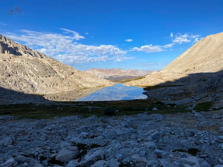
Guitar Lake Mirror

The Mount Hitchcock Massif and a look down where we hiked up

Looking down to Guitar and Hitchcock Lakes
I had to stop here and there to catch my breath, but I felt we made great time and made it to Trail Junction, which is about 2.7 miles, climbing about 2,000’ in 2.5 hours, dropping our heavy backpacks at around 13,500’.
The clouds were coming in and I started to get a little nervous. “Why so early?” I asked myself, as we quickly ate another snack at the junction. It was only about 10:30AM. With some more calories, we quickly packed our day packs and started up the Whitney Trail.
The first section is relatively flat and easy as you get introduced to the exposure to the west and the large rocks you have to hop over as you make your way to the summit. Only a few hundred feet along the trail, large amounts of hail started falling on us.
We paused for a second, getting on our rain shells before continuing on. My heart sank, as I didn’t have much hope the weather would improve, but we continued on.
We chatted with some people on their way down and they let us know the storms were fierce and started at 12:30PM the previous day. I guess the storms just didn’t make it down to us at Guitar Lake until 4PM. I looked at the time. It was only about 11AM. Perhaps we would make it.

Looking east through one of the windows - with hail falling
We kept on going until we passed some of the ‘windows’ where we could see all the way down to Owens Valley below.
At that point, the path to Mount Whitney became steeper and my pace slowed to a crawl, having to stop and catch my breath every 100 feet or so. This is the same place I hit a wall back in 2010.
I paused and did some thinking, and my daughter said, “C’mon Dad, you can do it.” She was doing better than me. We continued along the trail.
It started hailing again and we heard some thunder in the distance. Knowing we had about a mile left to the top, how slow we were going, and how the clouds to the south were coming quickly our way, I made the call.
With tears in my eyes, I said, “I am so sorry, honey, but we have to turn around.”
If I was by myself, I may have gone for it, but this was with my daughter, and my risk tolerance for her is an entirely different metric. Not even in the same universe as mine.
For years we planned this. She wanted this. And I had to heartbreakingly tell her that it wasn’t going to happen; she was not going to summit Mount Whitney at age 12, like her father.
We hugged each other in tears and said we loved each other. Wiping tears from our eyes, we headed down.

Mount Whitney seems so close
I was angry and frustrated. “The storms never come this early!” and “The weather report was supposed to be clear all week!” and “I’m so sorry, honey” kept coming out of my mouth as we descended back towards our backpacks at Trail Junction.
I kicked myself for not training harder, for not getting up earlier, for not packing more food, for agreeing to a training hike on the first day and not making it to Chicken Spring Lake the first day, and not getting her to speed up in the morning.
She melted my heart when she said, “We made the right decision, Dad” as the thunder continued to get closer and more hail came upon us.
We made it back down to Trail Junction and picked up our full packs and made the short slow motion hike upward to Trail Crest. We were cheering each other up with words of reassurance and I pointed up the talus slope to where the PD and I came over Discovery Pinnacle in 2010 to join the Whitney Trail.
We zoomed down the 99 switchbacks as the thunder and lightning continued to our right and there were black clouds practically touching the Whitney Hut up and to our left.

Mount Whitney from the 99 switchbacks. Plenty of weather

The rain is here

Pika on the 99 switchbacks
“We made the right decision, Dad,” she said again. “Next year, let’s bring more food and get up a little earlier every day. We’ll just camp at Horseshoe Meadow the first day and get started right away. And you’ll train more.” she said with a wink. “It’s the journey, not the summit.”
My heart swelled with pride. Here she was, minutes after being devastated about missing her long-time goal of summiting Mount Whitney when she was 12, and she’s joking around with me and already planning the next attempt.
Our next decision was whether or not we were going to spend the night at Trail Camp or try to make it to Outpost Camp, making tomorrow not that much of a challenge before the drive home.
We made it to Trail Camp in what seemed like no time at all. She had a couple of turned ankles and a slip on the switchbacks where she jammed her thumb, but we were feeling great. We stopped next so some large boulders as the hail came down again and thunder rumbled above us.
Compared to my 2010 trip, I was feeling many times better. We had passed many other college-aged hikers, who seemed to be exhausted. But I felt fine.
“Do you want to stay here?” I asked.
“Let’s make it to the car,” she said.
“We can reassess at Outpost Camp.”
“I feel great.”
“Me, too,” I said, “but this will make it nearly a 14-mile day, dropping 6,000’. I believe you can do it, but the last few miles won’t be easy. You’ll have to dig deep.”
“I can do it.” She said.
I believed her.

The way down is down
We hiked down the Whitney Trail. This section, between Trail Camp and Outpost Camp, was a little challenging; there are large sections of steep slick granite and plenty of rocks on which to turn your ankles. And it started raining on us. We were careful with our trekking poles, but we lost our footing plenty of times.

Lone Pine Creek Cascades
All this vigilance during the steep descent was wearing on us, but we were in good spirits.
The rain, lightning, and thunder lasted nearly the entire time between the camps, culminating in a downpour that left us laughing at its intensity as we took a brief break in the shelter of a thick juniper. So much water.
After what seemed like a long time, the trail got a little nicer and we dropped into Outpost Camp.
“We’re only 3.8 miles to the car,” she said, wolfing down a bar and some snacks with a huge grin. “Lezz goo!”
We put on our packs for the last time and started down. We saw some more mule deer just outside the campground as we sped down the trail. Again, we felt great and made great time. The trail wasn’t too steep and the scenery was beautiful. We started talking about the dinner we’d have once we made it back to town.
After 6 nights away from your home, the car tends to pull you toward it.
As anyone who has come down the east side of the Mount Whitney Trail knows, about two miles away from the trailhead, you can see the parking lot. It looks deceptively close. You feel like you’re almost there. But the trail swings to the south and back again. You walk for an hour and the parking lot doesn’t seem any closer. You’ve dropped thousands of feet of elevation and have covered many miles and you just don’t seem to be making progress.
This is where Sophia fell silent. Her feet hurt, her legs were tired from the elevation drop, and this was one of the longest days on the trail for her, even without the morning climb from 11,500’ to 14,000’, and technical terrain.
We talked about the food we would eat and how we’d text my wife when we got a signal, we checked our progress on the map, but those last few stretches of trail seemed interminable.
Tears fogged up my sunglasses as we saw the archway at the trailhead.
This wasn’t the triumphant ending I had envisioned all these years. We hadn’t summited Whitney and we descended into a world of COVID signs and people wearing masks. But the adventure was still amazing, beautiful, and heartwarming.
My sadness for her not being able to complete her goal combined with the pride I felt about seeing her immense inner strength emerge as she made it further along the trail.
Regularly along the trail, our love for each other was clearly expressed verbally and in our actions as we cared for each other during our tough moments.
Once again, the Sierra Nevada changed me. I am pretty confident this experience changed her, too.
We gave each other a great big hug and made it back to the car. And home.
Next year, we’ll give it another try. I’ll pack more food.
And train.
We’ll both be a little wiser.
Update: We did indeed return in 2021 and successfully summit Mount Whitney. It wasn’t without its own hitches, but our successful trip was wonderful.

