


Teton Crest Trail Backpacking Trip (2021) – The Perfect Window
The Teton Crest Trail is one of the premier backpacking routes in the United States, traversing dramatic alpine terrain beneath the rugged peaks of Wyoming’s Teton Range. This trip includes trail maps and documents a rare stretch of ideal weather conditions during a multi-day journey through Grand Teton National Park, where clear skies, alpine passes, and expansive mountain scenery combined to create the perfect backpacking window.
Teton Crest Trail
Route: Phillips Pass to Leigh Lake Trailhead
Nights on Trail: 4
Miles: ~40
Trailhead: Phillips Bench Trailhead
Agency: Grand Teton National Park, Caribou-Targhee National Forest
Dates Hiked: September 14-18, 2021
My LighterPack gear list specifically for this trip
For those interested, here is a list of my gear that I have found works well for me. This is, of course, an affiliate link and your enjoyment of these may vary:
09/14/2021
Everything lined up: Our time off, our flights, and the weather.
Once again, I met up with my adventure friends to spend some time outdoors. Throughout the year, we chat via group text about where we’d like to go next. We all have huge lists of adventures, and I am sure there is a ton of overlap.
The first year, it was the Wonderland Trail. The next year, it was the Ruby Crest Trail. This year, it was to be the Teton Crest Trail.
There’s something to be said about solid trail friends. We all have different experiences. We don’t typically see each other more than a few times a year, if at all. But when we meet on the trail, something just clicks and we are all on the exact same page. And that is what makes our trips so special.
Adam, (Dreamer), the newest member of our group, joined us on the Ruby Crest Trail, as a last-minute change of plans due to the wildfires in 2020.
Jason, who knew him, had asked us if it was OK for his friend to join us. He said something along the lines of, “Trust me, you’ll like him.”
We did; Jason was spot on. Adam immediately gelled with our group, even though he consistently and wildly outpaces us.
He was able to join us this year, although, much to all of our disappointment, the PD could not.
So the four of us, Jeff Hester (SoCal Hiker), Jason Fitzpatrick (@themuirproject), Adam, and I traveled from our corners of the West and met in Jackson, ready for adventure.
We loaded up on a nice meal and picked up our rental car, dropped off Jeff's Six Pack of Peaks Discovery at the exit trailhead, and headed out to Victor, Idaho, where we rented a home for before and after the trip. It was also fairly close to Phillips Pass Trailhead, where we would begin our journey.
We prepared our gear, thankful that Jeff was able to drive stove fuel and bear spray from Bend. We wouldn’t have to spend our time in Jackson purchasing it.
We relaxed into the evening, having dinner at a local restaurant, buying some cheese, joking about taking the tram up as a shortcut, and reacquainting ourselves with each other. We made some last-minute gear choices, readied our packs, and went to sleep.
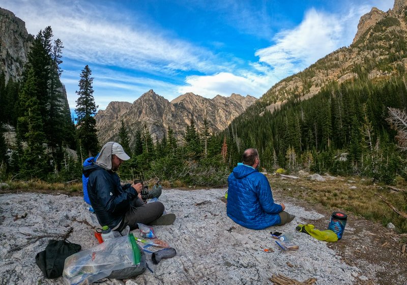
Day 1 - Phillips Pass Trailhead to Marion Lake - ~12 miles

Our motley group of friends, ready to head into the backcountry
(L to R) Jeff, me, Adam, and Jason
We checked out of our rental, had a tasty breakfast in town, and drove to the Phillips Pass Trailhead, fairly close to the highway. Leaving my rental car behind, we passed some day hikers and immediately started climbing up the thickly wooded trail.

Starting our adventure at the Phillips Pass Trailhead
At this elevation, the trail was still pretty green, but the telltale signs of autumn were all over, with scarlet leaves poking out from pale green foliage.
Research had led me to believe that there would be plenty of water during the first portion of the trail, but that wasn’t true, even if it had rained somewhere in the park the day before. We adjusted our packs, started our usual conversations about our lives and waited for our bodies to adjust to the trail.

A grove of aspen as we climb

Continuing to ascend on the Teton Crest Trail
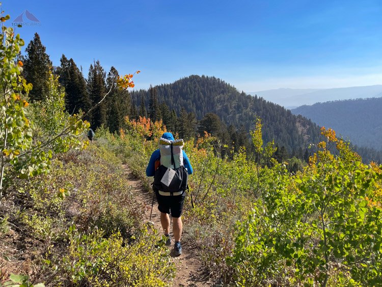
The views open up to the east
We stopped at a small creek for a break and enjoyed the shade before climbing again. The views opened up on the way to Phillip’s Pass, where we had some snacks. Phillips Pass was unusual in that we had to climb again not long after we got to the other side.

Nearing Phillips Pass on the Teton Crest Trail

Taking a break atop Phillips Pass
There was a beautiful stretch of open flat trail with a sweeping view of the hill ahead, flanked by forest. It was truly beautiful and would be a nice rest before the trail would continue to climb steeply to Moose Creek Divide.

A short flat respite before climbing again

Climbing toward Moose Creek Divide

Looking back toward Phillips Pass

The climbing continues
The trail hugged the eastern hillside above Moose Meadows as we climbed up. We took a snack break at a rock outcrop where hundreds of butterflies flew southwest along the trail. The trail dropped steeply for several hundred feet along a very sketchy section before it started climbing again.
Looking down toward Moose Meadow
As we neared Moose Creek Divide, we were treated with a stunning view of the Moose Creek headwaters. We ascended the final steep switchbacks before reaching the flat top of Moose Creek Divide, where we had lunch.

The trail up to Moose Creek Divide on the right and Moose Creek below
Refreshed, we set out again toward our destination of Marion Lake, and, you guessed it, started climbing again. Sometimes, gradual, but often steep, the hours of climbing challenged my stamina. We would climb up to a ridge, only to drop down to a low spot to regain our elevation.

Flat trail after Moose Creek Divide. Photo Credit: Adam
Looking down to the upper Middle Fork Granite Creek drainage

Climbing up just before the North Fork Granite Creek drainage
The final drop and climb for the day would involve us dropping ~400’ to North Fork Granite Creek, only to climb that same 400’ back up to Marion Lake, in the space of about a mile.

Dropping down to North Fork Granite Creek before the last climb of the day

Marion Lake is at the top of this climb
It was a challenging push at the end of a 12-mile day at around 9,000’.

A small, unnamed drainage near Marion Lake
But the effort was worth it. Just before Marion Lake, we came upon a small valley with a creek trickling through it. The late day sun shone on the fall colors and the effect on my mood was immediate. I practically skipped up the last hill toward the campsites, nearly running into a large deer who was staring at me from the bushes.

Deer Friend
Deer below the alpenglow
We got settled into camp at around 5:30PM, choosing a site near to the edge of the North Fork Granite Canyon below. The haze from a variety of wildfires was in the air, but it wasn’t too thick. We watched a herd of deer frolic through the trees and grass while we had dinner in the last warm sunlight of the day. Adam went for his usual evening stroll on tomorrow’s trail while I explored the area, finding non-legal campsites in almost every grove of trees I could find.
Marion Lake on the Teton Crest Trail
We considered a dip in the lake, but the sun was too low, and drying off before shivering would be a challenge.
Jeff let me know that he found a wisp of a cell signal on the edge of the canyon. I strolled out to the viewpoint and took the opportunity to update my wife and daughter on our day. We stashed our food in the nearby bear locker and retired to our tents, while Adam slept out under the canopy of the trees.

Granite Canyon from our campsite
Day 2 - Marion Lake to Death Canyon Shelf - ~4.3 miles
We took our time in the morning, having a lovely breakfast down by the lake before we set off on the trail. We had a short day to get to the Death Canyon Shelf. We climbed to the top of what I called Marion Pass before getting a great view of a sweeping plateau ahead of us.

Our breakfast spot at Marion Lake


In earlier months, this would be a green paradise, festooned with blooming flowers. But this time of year, it had turned brown. It was still very beautiful, and not having any mosquitos on the trip would be an excellent trade-off.
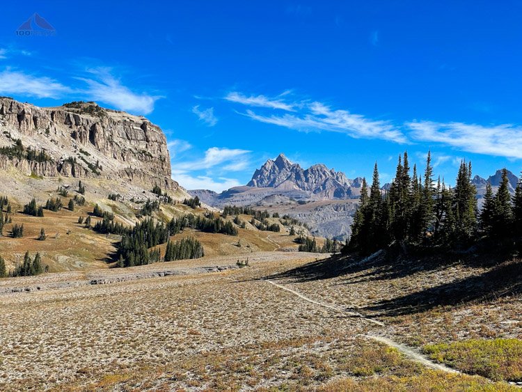
The Teton Crest Trail to the Death Canyon Shelf with Grand Teton beyond
Near Fox Creek Pass, we could see our first glimpses of the Grand Teton in the distance. Knowing we’d be hiking around the other side of those craggy peaks was awe-inspiring.
Looking down into Death Canyon
I kept taking photo after photo, enjoying the interplay of the rocky cliffs to my left, the rolling terrain dotted with trees ahead, and the mountains beyond. Next to it all, was a giant canyon below. It was a highlight of the trip.

Dropping down into the Death Canyon Shelf
We entered the Death Canyon Shelf and marveled at this flat ledge jutting over the canyon. We had sheer cliff walls to our left and a steep drop-off to our right. It’s hard to capture in photos, but the feeling of being on this geological oddity was unique.
The Death Canyon Shelf with Death Canyon Below

Grand Teton from the Death Canyon Shelf
We passed potential campsites here and there, but we were aiming to make it as far as we could on this short day while still having water near where we camped.
We had a nice lunch break on a sun-warmed boulder. The wind was around and keeping us company. We looked ahead and theorized what would be our path for tomorrow. We seemed to be almost at the end of the Death Canyon Shelf.

Our little creek by our campsite

A peaceful brook near our campsite
We headed up the trail a bit, passing a few streams and the group campsite and found a lovely campsite tucked into the trees above the trail. A clear creek trickled nearby. It had probably taken us around two hours to get to our stopping point for the day.
So we set up our tents, except Adam, who would once again sleep under the stars. We snacked, relaxed, and got water. We explored the adjacent area, finding another bear locker at the adjacent group camp, and a crystal clear and calm brook, between our site and the cliff face.

The bear box at the Death Canyon Shelf group camp
Once again, Adam trekked ahead to explore the trail for tomorrow while we whiled away our time at camp. We enjoyed the sun while the wind increased. We found some very large, but old, bear scat nearby and two more creeks.

Death Canyon northeast of our campsite

Upper Death Canyon southwest of our campsite
As dusk approached and cast the campsite into shadow, we strolled to the edge of the canyon, eager to feel the last bit of sunlight on us. We found a clearing across the creek to have our dinner and I found that cheese and freeze-dried beans go very well with the tortillas I brought. Jeff recommended that I add my Fritos to the mix and I was in heaven. This will become a staple of my backcountry meal menu from now on.

The Teton Crest Trail crew enjoying the final sun of the day
We held out as long as we could, as the haze came in from the east and the cold drove us into our tents.

Evening tent shot
Day 3 - Death Canyon Shelf to South Fork Cascade Creek - ~12.6 miles
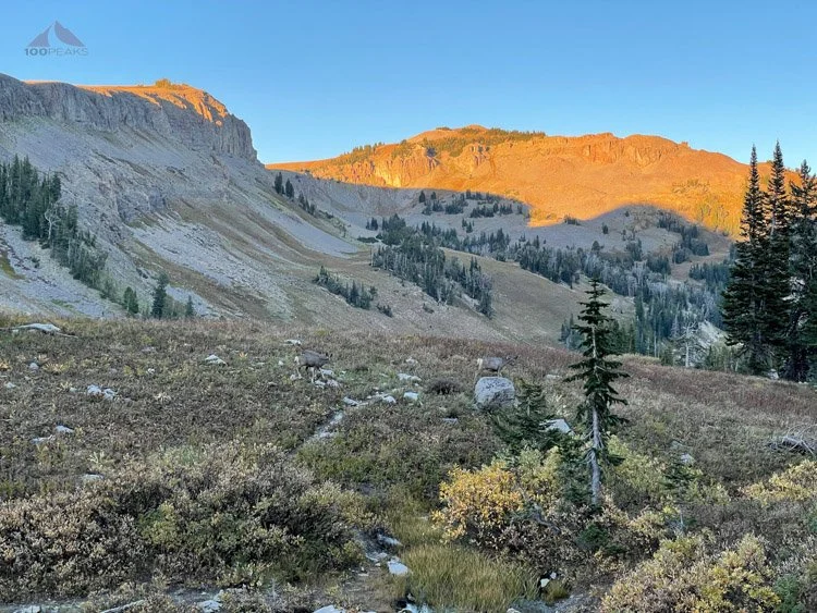
After a chilly evening, we emerged from our tents to find a small family of bighorn sheep ascending from the canyon below. After a bit of debate over what the animals were, (Sheep? Elk? Deer?), we watched them easily climb a route up the cliffs to our left, a challenging route for a group of human climbers the day before.
As we packed up our campsite, a woman backpacking a large loop route crossed the trail below us. Her trail name was Stripes and had an incredibly positive attitude.
On the Teton Crest Trail again

End of the Death Canyon Shelf, headed toward Mount Meek Pass

Almost to Mount Meek Pass
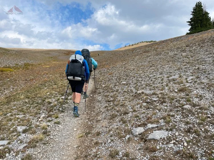
We headed up the gently ascending trail toward Mount Meek Pass, where we met Stripes again. This was the first time I’ve encountered running water near the top of a pass. We crossed a flat tundra-like area, buffeted by winds. We descended into the Alaska Basin via the Sheep Steps and were wowed by the views presented to us.

Dropping down to Alaska Basin

Sheep Steps above Alaska Basin
One moment we were traveling through a beautiful but relatively barren high plateau, and the next we were crossing creeks and passing lakes through a tree-studded landscape.

South Fork Teton Creek
Adam had enough lead time ahead of us to take a dip in a lake, drying off as we caught up to him. We had a snack and stared at the clouds racing above us. We all made sure our rain gear was within easy reach, just in case.

One of the Basin Lakes

Small boardwalk along the Teton Crest Trail
We made our way across the basin and climbed around a ridge to drop down to Sunset lake. Many people spend a night here, as this isn’t technically in the Grand Teton National Park, but our day was far from over. We still had to climb over Hurricane Pass and drop far down into South Fork Cascade Canyon before we’d be able to settle in for the evening.

Looking back toward the Alaska Basin, we came from the sunny area on the far right

Almost to Sunset Lake
Checking our maps, we realized that the notch in the ridge that we’d been looking at for a while was not Hurricane Pass. That was somewhere far to the left out of sight. As the wind continued to increase, we continued to climb steeply to the rim of the basin. We rose above the trees and the area reminded me of Iceland.

Headed toward Hurricane Pass (not in view)
Looking back from where we came from
The slow climb up to Hurricane Pass was a high grassy ridge. Every time we thought we were at the top, there was a little more to go. We finally made it to the top, clutching our hats and leaning into the wind.
Climbing toward Hurricane Pass
Hurricane Pass
We dropped down the first switchback on the other side of the pass and were greeted with silence. The wind was gone for now and we stopped to soak into the view before us.
Looking at South Fork Cascade Canyon from Hurricane Pass
There were so many things to take in. Schoolroom Glacier hung over its milky blue glacial tarn. The marshland below was dotted with lakes, connected by curling ribbons of creeks. Cascades of white water crashed down granite cliffs. The entire canyon was glowing from the yellow fall color, and the Tetons towered above it all. It was truly breathtaking.

Descending below Schoolroom Glacier
We scanned for moose and bear, since this was prime habitat, but were greeted by marmots and birds. We stopped to have a snack at one of the small lakes before descending into the canyon.

Why it's called Cascade Canyon
The question was where to camp. We passed campsite after campsite. We still had a lot of daylight left, so we continued on. About midway down the canyon, we started looking at campsites, but most were too small for our group of four tents. A perfect campsite ended up being too exposed to the increasing winds.

Dropping lower into South Fork Cascade Canyon

More cascades of South Fork Cascade Creek

Pond with moose tracks in it
We dropped and dropped, losing 2,000’ over the next few miles. We finally made it to the bottom of the canyon and hoped for the best. We found some sites near the South Fork Cascade Creek and got settled in.

Tent at lower South Fork Cascade Canyon
The site I chose looked big enough at first glance, but ended up being over a granite slab and a little close to another outcrop. After finding a few rocks and adding some guy lines, I was set up for the evening.

Waterfall from the shoulder of Grand Teton

Water below our campsite
We loaded up on water at the creek, looking up at an enormous waterfall that dropped 1,000’ from the shoulder of Grand Teton to our campsite below. We found a nice large granite slab to have dinner and relax.
Enjoyable dinner time at our South Fork Cascade Canyon campsite - Photo: Adam
Our time together is always pristine. I am not sure how to describe it. We laugh and smile and share our stories, some personal, some entertaining. We are comfortable enough to tease each other and always help each other in any way possible. We are giving of our time and efforts, and we are all here to share a positive experience. We encourage each other and always listen.
Although our next night would be just as memorable, our evening having dinner on this slanted granite slab overlooking the lower section of what I’ll call the Paintbrush Ridge will forever be etched in my memory.
As the sun painted the ridge across the canyon into an impossible golden hue, we felt the temperature plummet and we retired to our tents. All of us this time. No more cowboy camping for Adam.

Paintbrush Ridge from our campsite
Day 4 - South Fork Cascade Creek to North Fork Cascade Creek - ~3.6 miles
Although my campsite was slanted and it was a very cold night, this was the best night of sleep I’ve had in a while. Perhaps it was the effort from the day before, or perhaps it was the white noise from South Fork Cascade Creek. But I slept like a rock and slept long.
I could hear voices and realized that the rest of the guys had already made it to our slab for breakfast. As we chatted, Stripes came by to say hello. We offered her some coffee and we chatted about our respective adventures. She mentioned that it got down to 27 degrees F last night and we all believed it. It was cold and our water outside our tent had frozen.
She continued on her way, heading downhill toward the valley floor while we would be headed upward toward Paintbrush Divide.

A short day up North Fork Cascade Canyon
We collected our things and did just that, accompanied by tall trees and the sound of rushing water. As we made the left hand turn to continue upstream, we started to encounter day-hikers ascending to Lake Solitude. We crossed the rushing North Fork Cascade Creek numerous times.

Plenty of water along the trail

Deer Friend says hello

Crossing North Fork Cascade Creek several times
This being our shortest day, we were on the lookout for campsites that would fit all of four us. We encountered several small sites before we were at the top of the canyon. We explored the final campsites and found the perfect place, high on a grassy knoll, with an incredible view of the Grand Teton and the canyon below. It was spectacular.
Getting water from Cascade Creek
We erected our tents in the gusty winds, staking them easily to the grassy ground. There were creeks all around us. Adam explored the canyon wall to the east, almost inadvertently meeting tomorrow’s trail on the way to Paintbrush Divide.
I dropped down to the North Fork Cascade Creek and filtered water for dinner and beyond. I sat on a rock, water flowing around me in the middle of the canyon. It was a wonderful setting. I relaxed in the sun and the sound of the water as I took my time there. I could see Adam far above us. I could see Jeff and Jason relaxing at the edge of the knoll. It was a lovely day. I was calm and present. It was hard to believe that tomorrow would be the end of the trip. This was to be our final night on the trail.

Looking down Cascade Canyon to the Grand Teton
We met back in camp and decided to head up to Lake Solitude for a dip. We made it to the lake, just as the last day hikers were heading down. We got into the lake for an icy plunge. It was refreshing and we dried quickly.
Lake Solitude Pano
Another group of guys were nearby and were inspired by us to go into the lake. With some mild expletives, they submerged themselves and were glad they did. They were a group from North Carolina and their energy was contagious. They hiked very slowly, enjoying every inch of the trail. They hiked around to the north side of the lake to enjoy the view.
Adam and Jeff also hiked up the canyon to find a perch on a large rock while Jason and I enjoyed the sun at the edge of the lake. I eased onto a boulder, the granite still warm from the sun, warming my back, and soaked up the last rays until it dipped behind the ridge to the west.

Enjoying the last few rays of the day after a dip in the lake
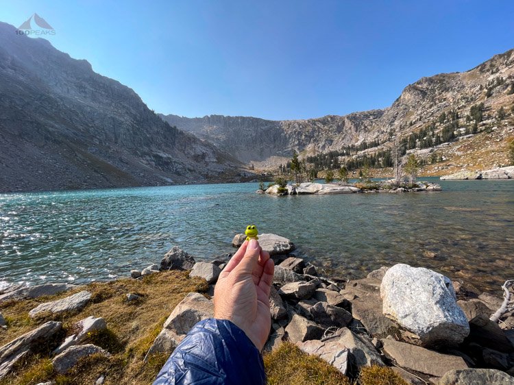
Froggy says hello
We all decided to hike up to a bench above the lake to watch the sunset. I was getting a little hungry when everyone started getting out their stoves.
I guess some plans were made while I was at the creek, because everyone brought their dinner and stove and I hadn't realized we were going to eat at the lake above. They offered me their food and had a little snack, but I said I was going to grab some grub once we got back to camp.

Headed up for a photogenic dinner spot
We found some rocks to sit on, with a full view of Lake Solitude and Grand Teton beyond. It was a very memorable evening. Jeff and I strolled into the trees, angling for a better view of the lake. There was a stealth campsite there, too.
Lake Solitude from above
As we sat there, the group from North Carolina came and joined us, settling in nearby to enjoy the sunset. We shared the view until dusk, when we dropped back into camp as the moon rose above us. The wind had died down to nothing. I ate a quick dinner under the red glow of my headlamp as we watched the moonlight play on the Grand Tetons and the canyon walls.

Our spectacular campsite at the North Fork Cascade Canyon
As the light dimmed and the moon rose, Jason set up his tripod to get some photos of the moon over the valley.
Jason getting a long exposure moon shot
We stowed our gear and went to sleep. As I drifted off, I smiled, thinking of our pleasant evening relaxing in the grass, watching the pink reflection of the Grand Tetons in the shimmering waters of Lake Solitude.
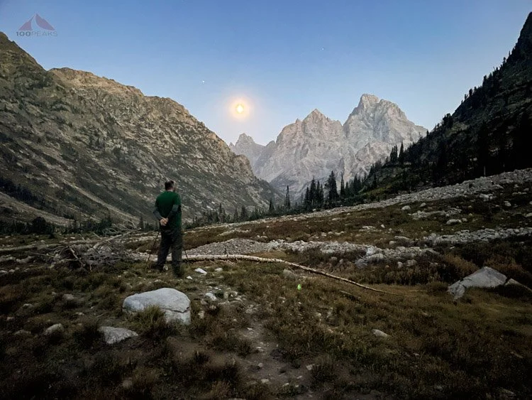
Day 5 - North Fork Cascade Creek to String Lake Trailhead - ~11.6 miles
We woke up before dawn, had breakfast, and packed quickly. Shining eyes in our headlamps startled us as we untied our bear sacks. A deer was grazing nearby in the darkness. As the glow of the day illuminated the sky to the east, we hiked back up to the lake and started climbing the long ramp leading to the Paintbrush Divide.

The Grand Tetons
This was another one of those moments where I stopped to take picture after picture, as the rising sun painted the Tetons a brilliant orange. Each minute brought a different shade of beautiful. There’s something about the growing morning light that takes my breath away, although I am sure the climb was contributing. It was one of those moments on the trail that has staying power. The feeling of gasping up that hill while the sun rose, shining light on all the folds of granite, will forever be etched into my memory.
Our morning view from the Teton Crest Trail (Click to Enlarge)
The ramp finally switched back as rain drops started falling on us. I was considering getting out my rain gear when I turned and looked behind us. The rain was falling from one large cloud that would pass above us. There was blue behind it. We should be safe from the weather.

Sprinkling on us near Paintbrush Divide
We turned a corner, expected to be presented with the pass. Instead, the trail continued ever upward, around another mountain, getting rockier as it climbed. Finally, we topped the pass and headed over the Paintbrush Divide.

False pass just ahead

Continuing to climb
“It’s not that windy here,” Jeff said, prematurely.
Not long after his statement, we encountered a knife-edge ridge and were buffeted by wind that nearly knocked us over. Carefully stepping, occasionally holding still until a particularly strong gust would pass, we inched our way over the narrow trail, hundreds of feet of exposure on either side. It was some of the strongest winds I’ve ever felt.

Almost to Paintbrush Divide
Looking back to Lake Solitude

Painbrush Divide to the left as we are pelted by the wind

Paintbrush Divide
The wind abated a bit once we dropped from the ridgeline, but the trail became a little treacherous. Mostly gravel and talus, the trail forced us to concentrate on every step; our shoes often slipped here and there.
The trail then disappeared, washed out by a rockfall. The only way down would require us to climb down some rocks with exposure, being wary of our heavy packs. We all have had experience with this type of exposure, so we carefully made our way down.

Dropping down the windy and sketchy Paintbrush Divide
We met Adam at a tiny tarn with the clearest water. We sat and had snacks until we were ready to start dropping some elevation. Between the Paintbrush Divide and the car, we would lose nearly 4,000’ of elevation before we’d be done for the day.

The trail leading us to Paintbrush Canyon
Passing by tarns and groves of trees, we got a steady rhythm, eyes darting for moose, elk, and bears. This would be our last chance of seeing them on the trail and did not want to miss them. We passed a ranger, who said a large storm was on the way.

Fall color on display as we descend
Our pace was steady as we continued to drop. We rested at a bridge, surrounded by greens, reds, and yellows. Jason had camped nearby before. We started seeing more day hikers as we plunged through the fall color.

Jackson Lake comes into view


More fall color on the Teton Crest Trail
Before long, we were at the level of the lakes and crossed a wooden bridge. We encountered a volunteer ranger who asked us about our trip. We told her our dates and she said we had completed our trip in the perfect weather window. Looking up at the clouds above, I agreed.

Jeff and I made it near the parking lot. Adam was in the lake, of course, and we all made it back to the car. We changed into our post-hike clothes and made a beeline to town for some food. On the drive, we could see the Grand Tetons being swallowed by the storm. In between gaps in the clouds, we could see snow collecting. We were thankful we had exited the mountains when we did. Anyone still in there would likely have to change their plans and drop down the nearest canyon to the valley floor.

String Lake
We ate at a busy brewery, mesmerised by the music and activity. We then got some coffee at a cafe and melted into the sofas there. We dragged ourselves back to our cars and headed back to our rental in Victor, amazed at the storm above us. Our car was pelted by falling rain as we picked up my rental car at the trailhead.

Almost to the end of the Teton Crest Trail
We showered and went out to dinner, having pizza and beer. Relaxing in the rental, we watched some videos, getting inspiration for our trip next year. We packed our backpacks for the flight and slept nicely.
Day 6 - Grand Teton National Park
The next morning, we had breakfast and said goodbye to Jeff, who began his long drive back to Bend. Jason, Adam, and I decided to take a drive through Grand Teton National Park in order to find some wildlife. We briefly saw a bear in the bushes, but otherwise saw very little fauna. The views, however, were spectacular and the storm still assaulted the mountains above.
I drove for hours, so did not get any photos, but really enjoyed the drive and the views.
We had some lunch in town and returned the rental car. We sank into the chairs at the airport until it was time to board. All three of us were on the same first leg of the journey; we all had layovers in Denver airport.

The Grand Tetons got snowed on for days
On the layover, I quickly said goodbye to my friends, as my connecting flight was 52 gates away.
As I sat in my aisle seat on the plane, I was very aware of how very lucky I was to have found this collection of individuals to share my adventures with. I look forward to seeing them whenever I can.
I reviewed the pictures from the trip on my phone, smiling to myself at all the happy, beautiful, challenging, and sometimes funny moments we shared on the trail.
I am very fortunate.
Teton Crest Trail Elevation Profile (Roughly) (Click to Enlarge)

