


Otay Mountain Hike – A Sunset to Remember (Peak #94)
Otay Mountain is a rugged border-region hike in southern San Diego County, offering expansive views across the surrounding backcountry and into Baja California. This route includes a trail map and follows remote mountain terrain to one of the region’s most scenic summits, where dramatic evening light and wide-open vistas can create unforgettable sunset conditions. It served as Peak #94 in my San Diego 100 Peaks Challenge.
Otay Mountain
Elevation: 3,568’
Mileage: 12.4
Trailhead: Otay Mountain Trailhead
Agency: Otay Mountain Wilderness (BLM)
Date Hiked: 10/15/2022
Peakbagger.com Page
For those interested, here is a list of my gear that I have found works well for me. This is, of course, an affiliate link and your enjoyment of these may vary:
10/15/2022
My wife and daughter had a weekend planned in Orange County, so I saw an opportunity to knock off some of the remaining peaks on my list. Both Otay Mountain and Tecate Peak are near the border, so the idea was that I could save some driving time by camping somewhere nearby.
I looked at the map for a good starting point and saw that the Pio Pico Campground was at the foot of the mountain. I made a reservation for a tent site and planned my trip.

Heading up the fire road to Otay Mountain
I drove down to South San Diego and through the lovely hills of Jamul and arrived at the campground to check in. I learned that their cafe closed at 3PM, so I’d have to find some dinner once I got back down from the mountain.
I chose a campsite and put my tag on the post. It was a little late, so I immediately drove out to a parking lot near my point of entry, at the bottom of Minnewawa Truck Trail.
The gate to the road was locked when I got there, but as I was getting ready at my car, a couple of Border Patrol vehicles opened the gate for a side by side ATV and then closed the gate after they entered. They drove off before I could ask them about access to the gate.
Given the late hour of 1:20PM, I was considering driving part way up the mountain to insure I was going to return before dark. But I headed up on foot instead.

Partway up the hill, looking back down to the Pio Pico campground
The trail on this peak is essentially a dirt fire road, with a couple of short paved parts. Given that it was a Saturday, there was plenty of vehicular activity. I stepped aside on many occasions, giving Jeeps, motorcycles, ATVs, and other 4X4 vehicles enough room to pass.

The first views to the west on the way up Otay Mountain
As the road gained elevation, views opened up to the west of the Otay Lakes, as well as downtown San Diego, the bay and Coronado. I could even see the Coronado Islands of Mexico.

An unfortunate sign of how winding the road is

Looking back down the road I hiked
The rain started and stopped over the next two hours, but I had my umbrella. The scent of the hillside was wonderful as I was able to see the Tecate Cypress growing on either side of the road.

A Tecate Cypress overlooking a view to the coast

A whole hillside of Tecate Cypress on the way up Otay Mountain
I reached Doghouse Junction and headed straight toward the antenna arrays above me. As I edged the highest point of Otay Mountain, the views into Mexico opened up.
Between the clouds, I could see the rolling Mexican mountains below. On a clear day, I imagine the views would be many miles in all directions, but my time at the summit was spent in the chilly white clouds that blew past the communication towers.

The Otay Mountain high point is the antenna array to the right

At Doghouse Junction, looking at the top of Otay Mountain to the south

Almost to the top of Otay Mountain

Roadrunner near the top of Otay Mountain

The antennae of Otay Mountain
I was glad to be at the top and glad to be outside, but I had to get back down before dark. I got back on the trail and made great time on the fire road, again getting passed by a number of people enjoying the fire road in their vehicles.

Selfie in the corner mirrors of Otay Mountain
As I descended, the sun appeared under the cloud cover and bathed the hillside in an amazing warm glow. It was a great way to end the hike, and I couldn’t stop taking pictures.
Sunset on the way down from Otay Mountain
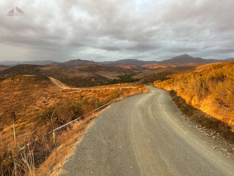
Sunlight on the hills of Otay Mountain
I made it to the car, hiking through the open gate at the bottom. I walked over to the general store, which was closing in 15 minutes, and purchased some dinner to make on my stove. I settled in for the night and slept cozily in my car.

Almost to the campground
I was only woken up by the rain on the roof of my car at around midnight. It was a wonderful sound. Tomorrow, I would be hiking up Kuuchamaa (Tecate Peak).
Otay Mountain Trail Map (Click to enlarge)

