


Mount Whitney Backpacking Trip (1984) – A Life-Changing Sierra Nevada Crossing
In 1984, a backpacking trip across California’s Sierra Nevada, including Mount Whitney, became one of the most formative outdoor experiences of my life. The journey introduced me to the scale, beauty, and emotional power of the high Sierra, shaping a lifelong connection to backpacking, wilderness travel, and mountain landscapes.
Mount Whitney
Elevation: 14,505
Route: Road’s End in King Canyon to Mount Whitney and Whitney Portal via Colby Pass
Nights on Trail: 10 (Including trailhead at Road’s End)
Miles: ~61
Shuttle: Self
Trailhead: Road’s End Kings Canyon Trailhead
Agency: Inyo National Forest, Sequoia & Kings Canyon National Park
Date Hiked: August 10-19, 1984
Peakbagger.com Page
1984 Mount Whitney Plan - Elevation Profile (Click to enlarge)
For those interested, here is a list of my gear that I have found works well for me. This is, of course, an affiliate link and your enjoyment of these may vary:
This trip occurred in 1984, when I was 12 years old. It was a defining moment in this very bookish boy’s life.
In 2020, I sent a letter to my old scoutmaster asking about details of this trip and he sent me photos and documents.

The note I received form my scoutmaster before writing this post
I remember my scoutmaster talking about the trip at our meetings. It sounded like an adventure. One of the prerequisites was that I was supposed to go on three training hikes, but I only ended up going on one. I expressed so much interest in going on this trip that my scoutmaster let me go without the prerequisite training hikes. Perhaps it’s because both my dad and brother were also going.
I was the youngest person on the trip by two years. I was paired with a troop member named Robert, who was likely around 17 years old at the time of the trip. Those five years are pretty important between the ages 12 and 17. I am sure I was paired with an experienced leader to make sure I would learn what I needed to learn and felt like someone had my back. He was gracious for accepting, as he could have easily been paired with the scoutmaster’s son, who was older and way more athletic than me. And I could have been paired with my brother or dad.
I didn’t know him very well, and don’t remember a lot of specifics, especially for spending 9 nights in a tent with him. But I do remember he was kind and encouraging with a great attitude and sense of humor, and very patient with my trepidation and discomfort on this long and challenging trip.
My family had gone to Sequoia for 6 years, staying in cabins, and had camped with our trailer. My Scout troop had camped at Joshua Tree and many other places over the years. I had also gone on a couple of backpacking trips; single-night trips to places like San Jacinto, San Gorgonio, and other places in the Angeles National Forest.
This was to be something special. Nine days in the wilderness while reaching the top of Mount Whitney. While many of the details of this trip are lost to time and fading memories, I’ll try to recount as much as I can, cued by photographs. Some portions are etched in this old brain forever.
For much of my early life, I was defined by this trip, which bisected my life up to that point. There was how I saw the world and myself before the Mount Whitney Trip, and then I became someone else after it.
In 1984, I spent my free time reading books and playing basketball in my driveway. Dungeons and Dragons and video games were among the ways my friends and I passed the time.
My closest friend and I dabbled with programming BASIC and ATASCII with our respective Atari computers. I experimented with my sister’s classical guitar and a Casio keyboard with dual cassette decks in it, but had not entered my relationship with writing music that I started later.
Let’s just say that I wasn’t an extremely physical kid. Nor did I have the confidence that I would ever be considered an athlete.
I had no idea what this trip would entail or what it would ask from me. But I ultimately found out that I was stronger than I thought and I learned what it means to dig deep.
The pictures from the trip are a combination of photographs and slide scans. When it was raining heavily, there are no photos. When there were significant geographic features, I was able to figure out where they were taken, a skill I was able to hone on my 1987 backpacking trip on the Tunemah Trail. When there weren’t any clues, like a picture of a creek among the trees, I took a lucky guess based on the order of the photos.
What I remember most is the rain and the gasping, and wondering what I had gotten myself into.
This was my first trip in higher elevation and carrying this much weight. And this was the first trip where I encountered rain. So much rain. There was only one day out of nine that it didn’t rain, and luckily that was our zero day, on day five.
I also remember the beauty and the vistas. The sight lines down a canyon to the mountains beyond. The sound of the creeks flowing next to the trail. The smell of wet soil, pine needles, and bark. The joy of reaching the top of a pass or mountain.
I learned patience and perseverance. I learned how to make a fire, organize my gear, and be on the move almost every day. I learned many of the skills that I use today on my backpacking trips.
I remember changing from an anxious 12-year-old kid into a more confident one, the more I learned about what I was capable of.
Preparation, Food, and Gear


Most of our breakfasts consisted of oatmeal and single-serving boxed cereals with powdered milk. Our dinners were Mountain House meals and desserts, which in my memory were actually pretty good.
Our lunches were a variety of granola bars and beef jerky, supplemented by GORP.
Our backpacks were heavy canvas or nylon external frame affairs, with heavy canvas ponchos large enough to fit over ourselves and our backpacks in the event of rain, which happened 8 out of 9 days. My camp shoes were Converse high tops. We slept on blue foam Ensolite pads in two-person tents. We all had mummy bags.
We carried multiple one-pound propane canisters, to be used with grasshopper stoves. We cooked in coffee cans, bringing with us Sierra Cups and plastic bowls and spoons. We hung our food in the trees, as bear canisters weren’t a thing just quite yet. We wore cotton shirts and blue jeans. I wore Bermuda shorts on warmer days.
I am not even sure if I wore sunglasses yet, as none of the pictures showed me wearing any. My boots were heavy and sturdy. We all carried moleskin for hot spots and blisters. We wore two pairs of socks, cotton athletic socks under thick wool socks.
Most of my gear and clothes were borrowed or hand-me-downs. I remember cramming a ton of bars and jerky into the lower pocket area of my backpack. I remember my tent poles rolled into my foam pad while hiking and having them try to slip out from time to time. I remember cutting pieces of foam and strapping them to my hip belt, as my hip bones were bruising heavily from the weight of the pack.
We carried heavy flashlights or penlights. We brought nylon line to hang up our clothes to dry. I am certain, with 9 days of food, that my backpack was likely double the weight of my current somewhat ultralight configuration.
We had translucent water bottles and filled them by straining the flowing water with bandannas. We did not bring water filters, but simply drank straight from the streams and rivers.
Our idea of ultralight food was not bringing double-stuffed Oreos, an on-going joke among the troop.
Day 0 - Orange County to Cedar Grove, Kings Canyon
08/10/1984
On this day, we met at 3PM at my former elementary school, where we held our troop meetings and where my scoutmaster lived a stone’s throw away. I would have just “graduated” in June, completing 6th grade. We then drove all the way to the bottom of Kings Canyon, camping in one of the campgrounds in Cedar Grove, possibly what is now called Sentinel Campground. We bought dinner along the road, likely McDonalds somewhere.
Since we were to get an early start the next day, and the adults were old school, everybody cowboy camped. This was my first time doing this, and my eyes were all over the place. Everything looked like a bear. Every night while cabin-camping in Sequoia between ages 6 and 11, we saw bears.
I remember, given that I was sleeping on a blue Ensolite pad, the ground was hard, but at least I was warm in my mummy bag.
There was a bright moon, so there were shadows everywhere as I squinted through the tall trees. I eventually slept.
Day 1 - Cedar Grove, Kings Canyon to Sphinx Creek
Mount Whitney Trail Map Day 1 1984 - Click to enlarge
Miles: 7.00
Gain: 4,336’
Cedar Grove Sentinel Campground before we left (I think)
We arose in the chilly morning, packing up our sleeping bags and rolling our mats up. We didn’t have to pack up our tents, so we may have gotten an early start. Given the photos of us in front of the van with our packs on, it was likely we got a ride from the campground to Road’s End.
Group shot at Road’s End in Kings Canyon NP, I am 3rd from the right
According to the meal plan, we had sweet rolls, boxed cereal, and milk. We took a group photo in front of the van before it left to meet us in nine days at Whitney Portal.
Bubbs Creek and Paradise Valley Trail Junction
The first part of the day was flat along the South Fork of the King’s River and I mistakenly thought, “This isn’t so bad.”
Yours truly on the Paradise Valley Trail
South Fork of the Kings River (I think)
According to the planning documents, the shared gear I was carrying was “Fly+Poles, Coffee Can, Fry Pan.” The coffee can was our stove pot and the frying pan was to be for some of the breakfasts, as well as any fish we might catch, though we cooked those over a campfire.
Rest break at the Bubbs Creek Bridge, I am on the right, my brother in the red shirt
Tim at the Bubbs Creek Bridge-Beginning of Sphinx Creek Trail
We took a break at the trail junction as it crossed over Bubbs Creek.
Over Bubbs Creek (I think)
Then we crossed the creek to the south and started climbing upward toward Avalanche Pass, gaining about one-thousand feet every mile, which, in my book, is considered steep. I looked upward and could see the lofty spire of The Sphinx, towering above us. It was hard to imagine the scale and that we would be ascending to a shoulder behind it.
Looking down Kings Canyon from the Bubbs Creek Trail
I remember the granite steps laid into the mountainside as the clouds opened up. We scrambled into our heavy ponchos and continued climbing, eventually making it to a camp in the trees at Sphinx Creek. It was raining, so there are no photos of that campsite.
The Sphinx from the Bubbs Creek Trail - 1984
Climbing up the Sphinx Creek Trail - 1984
Dinner was Vegetable Beef Stew, Pineapple Cheesecake, and Fruit Punch.
Day 2 - Sphinx Creek to Scaffold Meadow
Mount Whitney Trail Map Day 2 1984 - Click to enlarge
Miles: 8.4
Gain: ~1,800’
Getting a self-timed photo at Sphinx Creek Campsite (Possibly)
We probably got up earlier than I was used to and packed everything up, having a breakfast of oatmeal, Tang, and hot cocoa. We took a group picture and headed out and up.
We climbed up to Avalanche Pass, which didn’t have much of a view, and headed down toward the Roaring River. Along Moraine Ridge, we had endless views down into Cloud and Deadman Canyons.
At Avalanche Pass
Group photo at Avalanche Pass

The View of Glacier Ridge from the other side of Avalanche Pass
Although the mileage was a bit longer than day one, we moved downward, dropping about 3,000’ over almost 6 miles. We had time to splash in the Roaring River adjacent to our Scaffold Meadows Campsite. We met some horses along the way. It may have rained a bit once we neared the canyon floor.
Looking down into Deadman Canyon from Moraine Ridge
Another View down Deadman Canyon
Meeting some horses near Scaffold Meadows
The picture of our campsite would later inspire me to investigate its location and plot the journey of Stewart Edward White in his 1906 book, The Pass. A long and fun (to me) blog post followed.
Scaffold Meadows Campground
Another view of the Stewart Edward White camp at Scaffold Meadows
This may have been the campsite where we heard rumors of a woman putting cold cream on her face at night and getting visited by a bear. After doing some recent research, it was probably a rumor started by the fatal attack by a grizzly in Yellowstone in July of the same year.
We were able to hang our clothes to dry between the trees. Dinner was Beef Stroganoff, French Apple Compote, and Lemonade.
Tim and Robert take a dip in the Roaring River at Scaffold Meadows
Day 3 - Scaffold Meadow to Big Wet Meadow.
Mount Whitney Trail Map Day 3 1984
Miles: ~5.6
Gain: ~1,600’
Morning at Scaffold Meadows Camp
Scaffold Meadows Camp, I am in the blue vest, my brother in black, my dad in the green vest
We woke up, ready for an easy day of canyon travel. We had boxes of cereal with powdered milk, Tang, and hot cocoa.
Taking a break along the trail to Big Wet Meadow
Thunder Ridge from the trail to Big Wet Meadow in Cloud Canyon
We followed the canyon floor, taking the left into Cloud Canyon, hiking along the Roaring River. Before long, we were at Big Wet Meadow, and eased in for the evening. There are not a lot of photos from this day. It very likely rained off and on and we were probably in a tree tunnel.
Whaleback and Cloud Canyon from Big Wet Meadow, Sierra Nevada
Another View of Whaleback and Cloud Canyon from the trail to Bit Wet Meadow
Dinner was Chili Mac, Chicken Rice Soup, Chocolate Pudding, and Fruit Punch.
Big Wet Meadow
Yours truly getting fishing pole instructions
Day 4 - Big Wet Meadow to Gallats Lake, along the Kern Kaweah River
Mount Whitney Trail Map Day 4 1984 - Click to enlarge
Miles: ~8.4
Gain: ~3,800’
Looking down Cloud Canyon back to Big Wet Meadow from the trail to Colby Pass
Maybe my 12-year-old body was getting tired. Or perhaps it was almost 4,000’ of gain in about 5 miles, climbing up to 12,000’, the highest point I had ever been by far. This day was hard and is etched in my mind as a lesson in what it means to dig deep. I learned what I was capable of.
I had always had it in my head that we had overshot our campsite for the day and had hiked for about 12-13 miles. But measuring the route on modern maps made me realize that it wasn’t the distance that had wiped me out on this day, it was the elevation and the climb. I guess it had just felt like 13 miles.
We started out with a breakfast of oatmeal, Tang, and hot cocoa and then almost immediately started climbing the canyon wall toward Colby Pass. The steep trail crossed the Roaring River a couple of times before switching back up the side of Cloud Canyon, eventually crossing the river one more time before reaching Colby Lake, where we stopped to have lunch.


I remember sitting on a granite slab next to the lake with my dad and brother, scanning the headwall of the canyon, wondering, “How the heck would we get up that? It looks like a cliff!”
It wasn’t until I saw tiny people, the leaders in our party, zig-zagging up the face of the wall that I realized the rest of the day would be very challenging.
Heading up Colby Pass with tiny figures in the center
I was already pretty gassed getting to the lake, which sits at about 10,600’. I was about to find out what breathing was like heading up to the 12,000’ Colby Pass.
Looking back down to Colby Lake from the Colby Pass Trail
We put on our packs, hugged the left side of the lake, and started the nearly 1,500’ climb in about 1.4 miles. On the way up, the sky opened up and we put our ponchos on. The rain would last for a few hours.


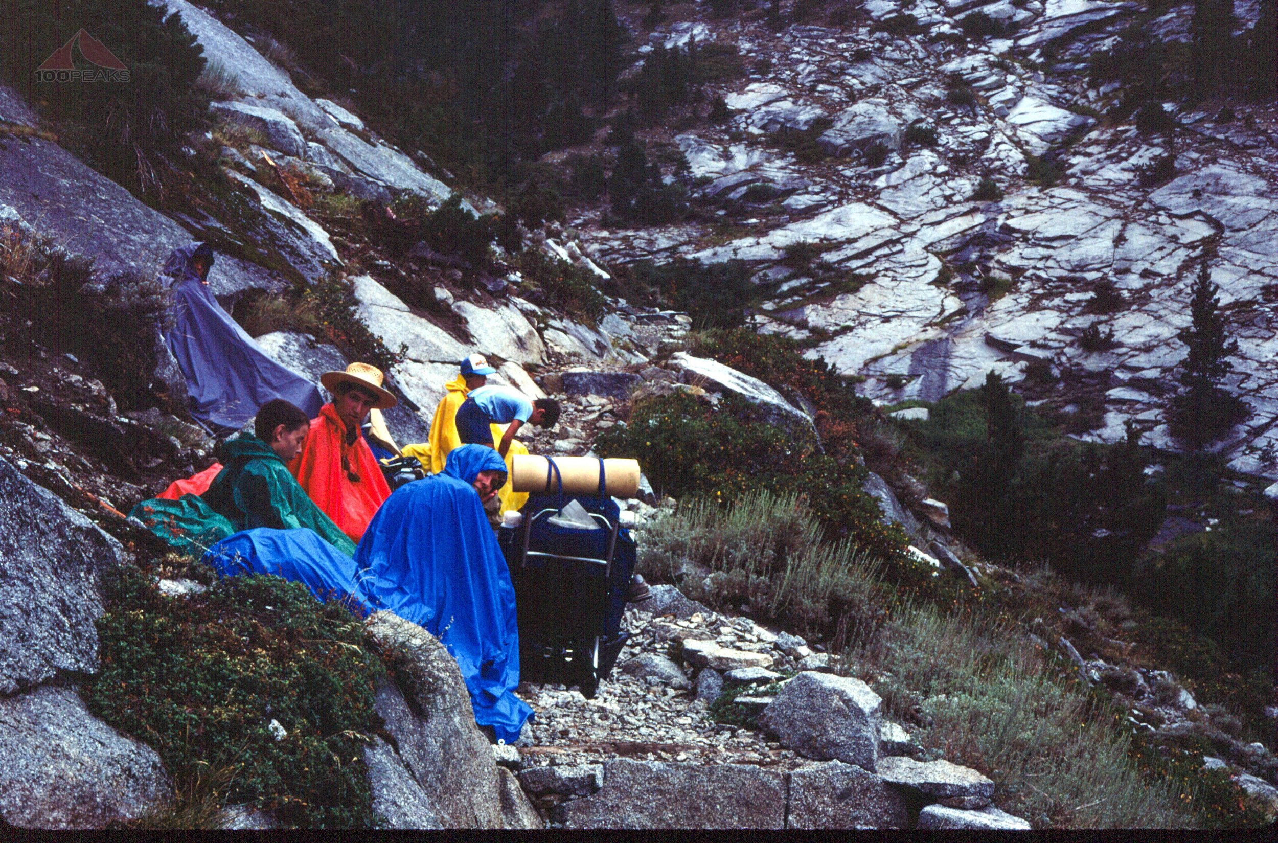


Nancy scrambling up an icier section of the Colby Pass Trail
The leaders of our group were waiting for us at the top. I was slow and gasping. I wondered why I opted to go on this trip. I was exhausted, both physically and mentally. I had hoped that the rest of the way would be downhill.
Everyone else was smiling and laughing at the challenge. I was at the end of what I thought was bearable.
The faster group at the top of Colby Pass
Huddled in the rain atop Colby Pass, I am at the far right
It was downhill, but it didn’t matter. I was already completely beat. The leaders took off down the trail. My dad noticed I was tired and offered to carry the frying pan. We headed down the eastern side of the pass.
We dropped and dropped. My legs were like jelly and I was still winded. We dropped 1,800’ in about 2 miles and stopped to rest. We hadn’t seen the rest of the group in quite some time and I was tired. I wanted to be done for the day, but there was more to go. We rested for a while until my dad encouraged me to keep going, as there was no choice other than to do so.
We hiked another mile or so and found the rest of the group, well-rested. We went for another half-hour or so and found some campsites near Gallats Lake, a meandering part of the Kern-Kaweah River.
I remember the drops of rain creating rings in the slow-moving glass s-curves of the river.
Getting a peek at the Whitney Crest from rainy Kern-Kaweah Canyon
The area looked very lightly used and we settled in for the night, having Mashed Potatoes with Gravy, Peas, Banana Cream Pudding, and Fruit Punch. The next day would be a zero day.
I was really happy about that.
Day 5 - Zero day at Gallats Lake, along the Kern Kaweah River
Miles: 0
Gain: 0’
Our group's catch at Gallats Lake on the Kern-Kaweah River - Tim and my brother
I remember this to be a wonderful day fishing in the river. This was also the only day that it didn’t rain on us.
We had a wonderful breakfast of Scrambled Eggs with Bacon, Hash Browns, Tang, and hot cocoa.
Cleaning fish at Gallats Lake on the Kern-Kaweah River
Since this area was very rarely visited, we caught a lot of fish. I remember counting about 40 fish between the ten of us. We grilled them over a campfire and had a wonderful dinner, supplementing our Lasagna, Apple Sauce, and Grape Punch. We were a hungry bunch.
A very tasty dinner at Gallats Lake
It was the best fish I ever had, probably the first time ever having fish that hadn’t been frozen and breaded. Someone may have brought some buttery seasoning. It was a perfect rest day.
Day 6 - Gallats Lake, along the Kern Kaweah River to Junction Meadow
Mount Whitney Trail Map Day 6 1984 - Click to enlarge
Miles: 5
Gain: 400’


This was an easy day in terms of mileage and gain. We had cereal, Tang and hot cocoa for breakfast.
Hiking down Kern-Kaweah Canyon with the Whitney Crest in the distance, I am in the lower center
I remember getting to our campsite among the trees early and being able to relax and enjoy the place. I helped gather wood for our campfire. I felt myself getting stronger.
I have a vague memory of hanging our food bags in the trees and waking up to the sound of rustling. Switching on our flashlights and aiming into the dark, we saw the glowing eyes of a mule deer shining back at us.
We had a nice evening hanging around the campfire. In a couple of days, we’d be on top of Mount Whitney.


For dinner, we had Chicken and Rice, Banana Cream Pudding, and Lemonade.
Day 7 - Junction Meadow to Guitar Lake
Mount Whitney Trail Map Day 7 1984 - Click to enlarge
Miles: 11.5
Gain: ~4,500’
My Dad and I climb the Wallace Creek Trail with Red Spur in the distance
This was a long day, but I felt myself getting stronger. Perhaps it was dropping down to 8,000’ at Junction Meadow, but I felt I earned something getting over Colby Pass at 12,000’.
Our breakfast was oatmeal, Tang, and hot cocoa.
Nancy on the trail to Guitar Lake with the Kaweah Peaks Ridge behind her
We climbed immediately on the High Sierra Trail, following Wallace Creek up the side of Kern Canyon. We could see the Red Spur and the Kaweah Peaks Ridge behind us.
I look at the picture of my dad and me, with the Red Spur behind us. We climbed into the sun from the canyon below and I have a look of resolve on my face. I had gained something along the way. I was standing a little straighter, taller. I was ready to climb Mount Whitney. I was ready for the day ahead.
Taking a break on the way to Guitar Lake with the Kaweah Peaks Ridge behind us
We stopped for a break at Crabtree Meadows and continued to climb, once again caught in afternoon thunderstorms. We set up our camp on the rocky hill on the north side of Guitar Lake. Given the mileage for the day, it was likely that it was getting dark by the time we arrived.
Our stormy camp at Guitar Lake
We set up a tarp to protect us from the rain as we made our dinner of Turkey Tetrazzini, Chocolate Pudding, and Fruit Punch.
Day 8 - Guitar Lake to Mount Whitney to above Outpost Camp
Mount Whitney Trail Map Day 8 1984 - Click to enlarge
Miles: 10.5
Gain: ~6,110’
The view from Mount Whitney down to Owens Valley
Summit day. This is what we had been talking about for months. We had a quick breakfast of cereal, milk, Tang and hot cocoa.
Since there are no pictures of the climb itself, I can only assume we started in the dark or it was raining. Or both.
We climbed up the switchbacks above guitar lake, an area I am very familiar with now, since I visited it with my daughter in 2020 and with a successful summit in 2021.
It rained off and on as we dropped off our packs at Trail Crest and continued along the fangs, as we call them. I remember gasping and taking a few steps and catching my breath.
My dad’s words of encouragement kept me going. I wasn’t feeling strong, but I wasn’t weak, either. It felt good to have the pack off of my back.
Mount Whitney Plaque
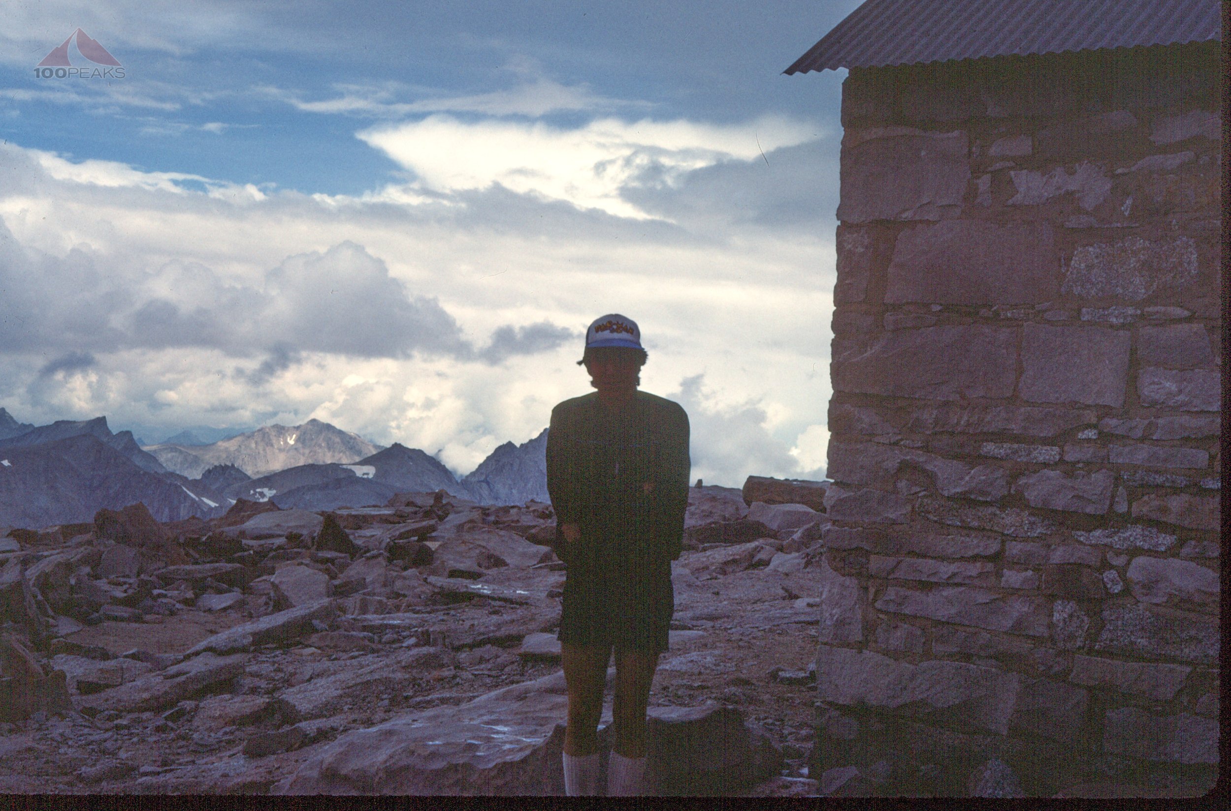
The gasping continued as the hut came into view.
That hut.
It lets you know that you’re almost there. That you are strong enough to complete what you set out to do. That there will be very little climbing for the remainder of the trip.
That you are good enough. I might have been a 12-year-old kid with very little backpacking experience, but I was able to draw from my being the sheer will power to get here. To hike from the western side of the Sierra Nevada over 60 miles to the eastern side.
We’re at the top of Mount Whitney in 1984
My dad and I are at the top of Mount Whitney, 1984, toilet wall in the background
Here I was, in Bermuda shorts, a borrowed yellow windbreaker, and my blue puffy vest underneath. An oversized wool beanie rested on my head.
The relief of the successful summit suddenly relaxed my stomach and I had to have a bio break on the top of Mount Whitney. At the time, there were two toilets on top and I made use of one. The toilets had been there since the 1960s and were removed in 2006.

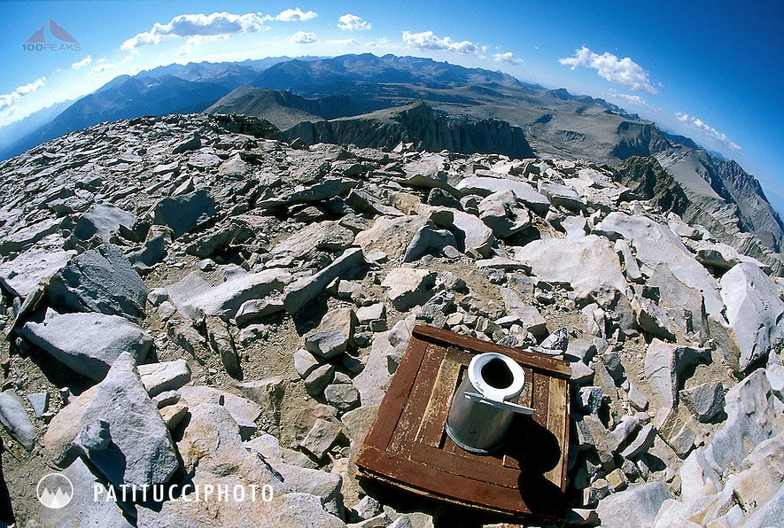
It was the best view I ever had while on the toilet.
We took pictures at the top, including a couple with my dad.


We heard thunder and could see the approaching weather, so we got off the summit, collecting our backpacks at Trail Crest and headed down the 99 switchbacks under a downpour of heavy rain and hail which wouldn’t relent for hours. Therefore, there are no pictures.
We passed Trail Camp, aiming for Outpost Camp. The hail continued until we finally called it quits, high on a ridge just below Trailside Meadow. We quickly set up our tents and ducked in, wanting shelter from the pelting hail. We made dinner in our vestibules and called it an evening.
We had Beef Stroganoff, Apple D’lite, and lemonade.
We were happy to have summited and were happy to be almost done. Although we were wet and cold, we were in a good mood. We sang McDonalds songs from their commercials and slept well.
Day 9 - Above Outpost Camp to Whitney Portal
Mount Whitney Trail Map Day 9 1984 - Click to enlarge
Miles: 4.75
Gain: 468’
Our camp below Trailside Meadow, just above Outpost Camp
We woke up to a sunny morning and spread our tents and clothes out to dry. Lone Pine Creek cascaded nearby among the granite slabs.
We packed up our things and headed down.
I distinctly recall seeing the wife of one of the dads on the trip hiking up the trail and I knew I was almost done. I was hungry and tired and she was a sight for sore eyes. I shouted her name and exclaimed how happy I was to see her and gave her a stinky hug.
We made it down to Whitney Portal and the waiting van. We changed into clean clothes, which was for me a t-shirt, sweat pants, and clean socks.
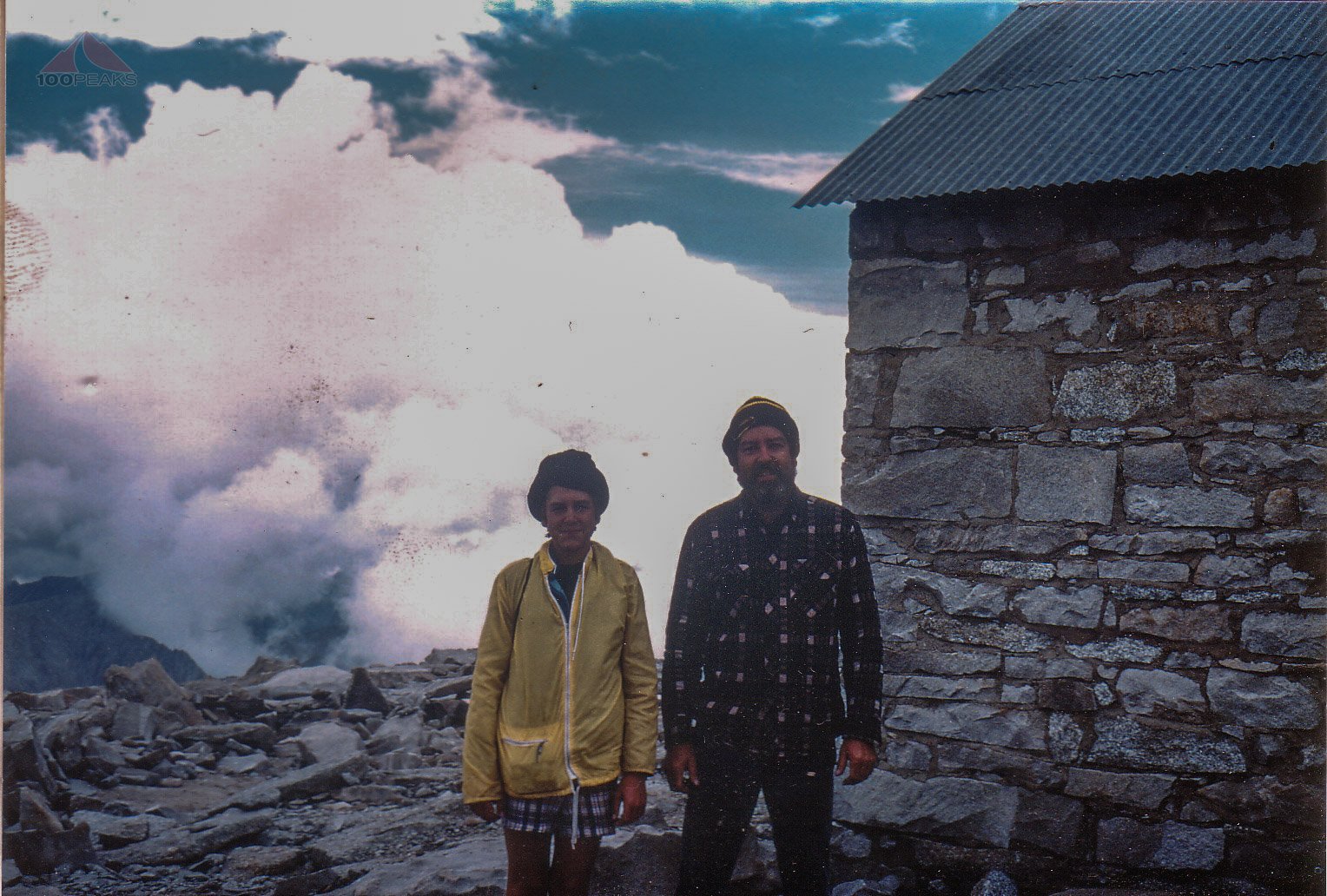
Group shot at Whitney Portal
We piled into the van and headed to the McDonalds in Lone Pine, where I ate the most I ever had in one sitting.
We came home and unpacked everything outside in the backyard, hosing off the things that needed hosing off.
I remember seeing the world differently after I returned. My friends commented on my legs and my attitude. I exuded a calmness and confidence that I didn’t have before. I had learned what I was capable of. It was hard, the hardest thing I had ever done. But I had done it.
My friends couldn’t even fathom the determination it required of me to complete it. Any challenge in the outside world paled in comparison. I remembered the feeling in 2010 after I returned to civilization after summiting Mount Whitney.
This was a defining line in my life. There was the time before Mount Whitney and then there was the time after.
It planted a seed in me that exists to this day, nearly 40 years later as I write this. I still undertake experiences that both challenge and reward me.
I returned to Mount Whitney with my brother-in-law, the PD, in 2010, and with my daughter, missing the summit by only a mile in 2020, and having the time of our lives in 2021.
My daughter and I always look at Mount Whitney with reverence and happiness whenever we drive by Lone Pine along the 395. As my father and brother shared the experience with me, I also share the experience with my daughter.
She now has that defining line that I had and knows she can do anything she sets out to do.
Adventure changes you. If you allow it.
Apres-Hike gear hose-down in my backyard with my dad and brother

