


The Arctic Circle Trail 2022 - 100 Miles in Greenland
For those interested, here is a list of my gear that I have found works well for me. This is, of course, an affiliate link and your enjoyment of these may vary:
I have also created another blog post about the Arctic Circle Trail titled: Arctic Circle Trail: Tips, Thoughts, and Recommendations
This trekking portion of the trip occurred from Kangerlussuaq on June 25, 2022, arriving in Sisimiut on July 03, 2022.
Planning the Adventure
“You’re turning 50 next year,” my wife said. “You should do something bigger than that.”
It was 2021. I was researching what summer trip that my daughter and I would be doing next year, in 2022. I would, in fact, be turning 50.
I had searched around and crafted a 10-day road and backpacking trip through a relatively unvisited mountain range in Oregon. I had been looking for something reasonable and not too expensive.
After my wife’s encouragement, I perused my larger global wish list, looking for places that I’ve always wanted to go to, but seemed too far, too expensive, or simply out of reach.
I looked in Europe, but many of the trails seemed very busy and required us to stay in huts bursting with people. This was in the autumn of 2021, when COVID was rampant, and it was hard to imagine being packed into a hut with many people, or sharing the trail with a constant stream of day hikers. Some European countries don’t allow wild camping as we do in the States.
Much of the advice online was to look toward Scandinavia, since wild camping is the norm, with permits rarely required. I searched in Norway and Sweden, and a trail into Finland. My eyes landed on a trail that I had researched years earlier: The Arctic Circle Trail, in Greenland.
I had read a few blog posts and it had piqued my interest. Greenland was a place I’d never thought I’d be able to visit. It was a giant swath of white that varied in size depending on what map you were reading. The pictures looked amazing.
Further research revealed we’d have to fly to Copenhagen, and then back to Greenland, in order to reach the trailhead. Other flights landed in Iceland, but then flew to Nuuk, Greenland’s capital city.
While reading, it appeared that there were plans to build an ATV road on or near the trail itself, thus reducing the wildness of the experience. Part of the ATV road had been built already.
I felt like this was the time to experience the trail as it was meant to be, before it was spoiled by the ATV road. I put the details on the spreadsheet and researched the flights. They were on two different airlines and not all of them flew every day. I chose dates that reduced the cost and flight time. It was logistically complex.
I pulled the trigger in October 2021. We were to fly out July 26, 2022. By then the mosquitoes would be lighter and the trail would be drier. There would be a smaller chance of rain and high wind, and more chances of sunny days. The biggest river along the route should be low enough to ford with ease.
We were excited.
The Rebook
Eight months later, something came up at the end of the summer that my daughter could not miss. We weighed our options.
Back to the spreadsheet. It would cost us, but we could reschedule a month earlier, just after she got out of school and before other summer commitments would start.
On June 2, 2022, I re-pulled the trigger. Since my original booking, global events had increased the cost of flights dramatically. But we had sunk costs and were ready to go.
Even waiting one year could make a big difference in the ATV road. Greenland was creating a southern route to circumvent the road, but it wasn’t ready yet.
I rebooked 5 flights on two airlines, 4 hotels, two tours, and a shuttle. The good news is that there would be fewer people on the trail this early. The bad news was that, looking at recent satellite photos, there was still snow at the western end of the route. Reports at the beginning of June indicated that the snow fields were waist-deep.
I scoured the beta until we were ready to leave.
Pre-Adventure
Day 1 - LAX to Copenhagen - Take the tours to stay awake
We were all packed and ready to go. Sophia and I had spent the weekend packing food and getting our backpacks ready to be checked in. My wife drove us from San Diego to LAX and dropped us off. This was getting real.

At LAX and ready to go
It was interesting watching us fly over Greenland, only to return in two days to start the trail.


Upon arriving, it was our plan to stay awake until the evening, so that we could get used to the time change as soon as possible. We caught a cab to our hotel downtown.

Nyhavn in Copenhagen
We arrived and dropped off our bags at the hotel, since our room wasn’t ready. We walked to Nyhavn and got some Gelato. It was delicious and gave us the energy to go on a boat tour. We then had lunch and went on the double-decker bus tour for the remainder of the day. We went back to the hotel, exhausted. We grabbed some dinner at the hotel and got some great sleep.
Day 2 - Vikings and Tivoli Gardens

Our hotel room in Copenhagen
The next day we had breakfast at the hotel and went back to our room to relax. In the afternoon, we headed to the Museum of Danish History and Culture. We only had two hours, so we focused on Viking history and we were not disappointed.

Exploring the Museum of Danish History and Culture
We then went to Tivoli Gardens and stayed until it closed. We rode many rides and had a blast. We only had a day and half in Copenhagen. We got a great idea of the city, but would definitely like to return.
We returned to the hotel and made sure we were packed, as we had an early flight out the next morning.

Enjoying Tivoli Gardens
Day 3 - Copenhagen to Kangerlussuaq
We took a 6AM cab to Copenhagen Airport and got there in plenty of time. Check in was easy and, before long, we were in the air on our way to Greenland. Sophia slept the entire flight, waking up to see Greenland out the window. We landed at Kangerlussuaq at 9:40AM, due to the time change.

Waiting for our luggage at the Kangerlussuaq Airport
The tiny airport was a little jarring, as there were few signs and no immigration control. You just left the plane and you were in a large room. We collected our bags from a small room downstairs. We exited through some doors and found ourselves in the cafeteria. We headed upstairs to the hotel.
We had an Ice Cap Tour with Albatros at 1PM and our room wasn’t ready, so we locked our bags in their baggage room and hung out at their lounge.

Waiting for our room from the Kangerlussuaq Hotel Lounge
Sophia fell asleep again at the table. When I went to get something out of our bags, I was informed that our room was ready early. We got settled and took a quick nap, getting up refreshed in time for the tour.
Akuliarusiarsuup Kuua from our tour bus
We got on the bus and headed eastward and upward. We immediately saw a reindeer out on the river plain, and then an arctic hare. Before long, we saw a musk ox in the distance on the other side of a small lake. We kept saying, over and over, “Whoa, we’re in Greenland.”


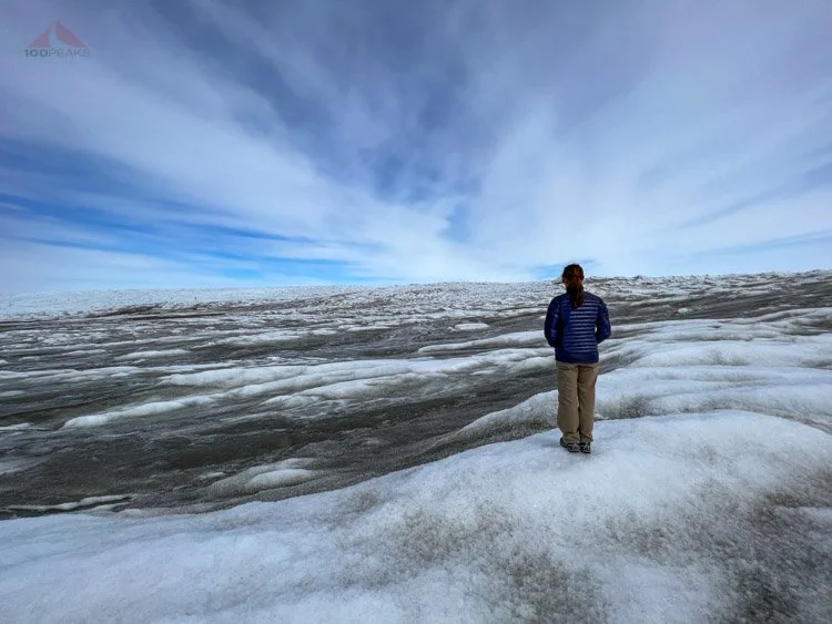
We were in awe at the scale of the valleys and mountains. The air was clear and we could see for many miles. We saw a couple more reindeer and made it to the ice cap. It felt great to stretch our legs as we hiked on the short rocky trail to the ice.


I believe we were the only native English speakers on the bus. Everyone else spoke Danish. So it was nice that our guide walked with us and shared with us some interesting facts about the ice cap and Greenland in general.
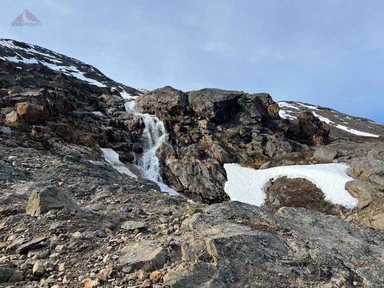
Looking at the Russell Glacier in the distance
‘Have you hiked the trail yet?” he asked, looking at our hiking shoes.
“We start tomorrow,” we replied.
He shared with us his experience on the trail before Sophia and I walked out onto the ice and explored the blue, gray, and white landscape. It was otherworldly, reminding us of our time on glaciers in Banff and Iceland. I highly recommend the Greenland Ice Sheet Point 660 Tour by Albatros

Hot cocoa picnic break overlooking Russell Glacier and a large waterfall
We rode the bus back, had some hot chocolate overlooking a waterfall and made it back to the hotel for some dinner at the cafeteria. We settled in for a relaxing evening and slept really well.
We were still exhausted, but tomorrow the real adventure was to begin.

Midnight view from our room at Hotel Kangerlussuaq
The Arctic Circle Trail
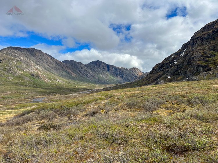
Day 1 - Kangerlussuaq to Kellyvile to Katiffik - 13.7 miles (22km)
Arctic Circle Trail Map - Day 1 - Kellyville to Katiffik (Click to enlarge)
We woke up on a Saturday morning and had a hearty breakfast downstairs at the cafeteria. We headed back to the room and assembled our backpacks, getting them ready for 8-9 days on the trail. We had built in two extra days, just in case the weather turned bad or we wanted to spend a night or two out in our tent.
While there were 7 huts on the trail, and most people complete the trail in 7 nights, we were going to play it by ear. The sun would never truly go down, so we could hike as far or as short as we would like and camp wherever there was a decent water source and a flat spot for a tent, or we’d camp in a hut if there was room.
Since it was so early in the season, we’d likely see few people and have plenty of room in the huts.
We put all of our stuff that we weren't going to carry on the trail into my large flight bag. My research indicated that I just needed to carry the heavy bag across the street to the post office and they would send it to Sisimiut, either to the Hotel or the post office there and I would simply pick it up. I would figure out the process once I spoke with them.
Upon walking across the street and trying the post office door at around 9:45 AM, we discovered it was locked. I chatted with a local and he had his son translate for us, and we determined that the post office was closed all weekend, and would not open until Monday. Again, today was Saturday.
In all my preparation, I neglected to realize that I was heading out on the trail on a weekend. This was all totally my fault. I had focused on the availability and costs of the flights on certain dates from two airlines and forgot that some places might be closed on a weekend in Greenland.
Kangerlussuaq Map (Click to enlarge)
Time to check out Plan B. I hauled the bag back to the airport and chatted with an agent at Air Greenland, who instructed us to head over to the Air Cargo building, which is a blue building to the west. They tend to close when planes arrive, though. We took a chance and hauled the heavy bag over there, not finding it right away. It is the last big building to the west of the airport.

Kangerlussuaq Airport Cargo Center Hours at the time of our trip
We were greeted with a printed sign duct taped to the wall next to the door that indicated they were only open from 8-10 AM on Saturday. I checked my watch. By now, it was 10:30 AM. I took a chance and rang the doorbell. In a few minutes a worker came out and pointed to the sign. I asked if I could ship something, as we were heading out on the trail. He told me to wait while he checked.
He came back in a few minutes and told me they were closed and shut the door. Frustrated with my own oversight and with potential solutions echoing in my head, I hauled the big bag back to the Airport and spoke to the agent. I asked if there was any other way to get my bag to Sisimiut.
“Nope,” he said, shaking his head.
I brought my bag back to the cafeteria while I tried to think of solutions. How did I forget that we were leaving on a Saturday?
I could check the bag in with the Hotel and leave it here while we backpacked the trail and pick it back up on our layover on the way back to Copenhagen in 11 days. We wouldn’t have any clean clothes or normal hotel items for Sisimiut, but that wasn’t the end of the world. We could take out some non-backpacking clothes and carry them for 100 miles, should we choose to do so.
I decided to take a chance with a different Air Greenland agent.
I approached the counter and explained to her that I was trying to ship this bag to Sisimiut as I am going on the Arctic Circle Trail. She said they are open until noon on Saturdays. I told her about the new sign. She offered to call them and did. I could tell by the look on her face that they told her they were done for the day. She relayed the bad news to me and could tell by the look on my face that I was bummed.
I asked if there was any way in town that could get this bag to Sisimiut? She thought for a second and said, “I will do it for you.” She quickly wrote down her name and number, as well as some numbers and letters.
“Give this paper to the airport in Sisimiut and they will have your bag. Bring your bag around to the door in the hall. You can pay for the bag in Sisimiut when you pick it up.”
We brought the bag around and thanked her profusely. This removed a giant worry from my head. I wasn’t sure how she was going to do it, but she obviously knew what she was doing. We thanked her again and walked over to the market across the street to buy some gas for our camping stove for the trip, with relief in our hearts.
We found the camping section at the back of the market. We then noticed other types of gas, but not ours. I asked a worker and she checked the back, opening up a large box full of gas canisters and placing a bunch on the shelf. We bought two.
We then went back to the cafeteria to wait for our ride to Kellyville through Albatros, the official start of the Arctic Circle. We were able to say hello to L&E, a Danish father and son backpacking duo who had just arrived in Kangerlussuaq and were starting the Arctic Circle Trail from the airport. We had connected online and wished each other good trips.
On a side note, Albatros was super easy to work with and can help anyone with logistics and tours in the area. I highly recommend them, especially if you’d like to know that your transfer or taxi ride is scheduled in advance as you plan a complex adventure. They easily rescheduled our days when necessary.

Our bus to the Old Camp
We went outside to wait for our driver, who was very friendly and chatted with us about his time on the trail. From the van, we saw L and E, who had started hiking earlier in the day from Kangerlussuaq. They were having lunch on a scenic rock outcrop overlooking the fjord and we waved as we passed.

The first trail marker on the Arctic Circle Trail
Before long, the driver dropped us off at the turnaround near the end of the road. We could see the first marker for the Arctic Circle Trail. He let us know the trail started a few hundred meters ahead.
We thanked him and suddenly, he was gone, and we were alone with the silence and the heavy packs on our backs. The end of our trip was 100 miles to the west and we had just an idea of what would come in between.

Our first picture on the Arctic Circle Trail
It looked like we had a cell signal, so I attempted to send a picture of us at the trailhead to my wife, but it bounced immediately and would show unsent every time I turned on my phone for the next 9 days.
It was sunny with a slight breeze. The rolling hills were green and brown around us with tiny flowers blooming here and there. A lake lay below us. It was very quiet. The mosquitoes were out, but not too obnoxious.
There was no obvious start to the trail, other than the boulder next to us with the red Greenlandic semicircle painted on it. I consulted the guidebook. We followed an ATV track down to the lake and found the trail just to the left of it.

The first steps on the Arctic Circle Trail, heading down to the first lake
Already the ground was marshy as we settled into the idea of being in Greenland, heading out into the wilderness. We were in great spirits, and had felt surreal. We immediately saw a reindeer run up the hill above us.
“We actually did it. We’re here, in Greenland,” we said to each other, with smiles on our faces. It was 2:10 PM. A late start, but we had as much daylight as we wanted and the day felt gorgeous.

Headed toward Hundesø
The hike was easy along the rolling terrain. There were some boggy spots, but not too bad. The breeze was blowing enough to keep the mosquitoes at bay for the most part and cool us off from the sun. Our packs were heavy, but the trail was easy. I would occasionally check my GPS to make sure we were on the right track.

Small lake before Lake Hundesø

Hundesø hut
We got to the Hundesø hut in no time at all with no intention of staying; we were headed to a distant hut called Katiffik.

The Arctic Circle Trail with a marker past Hundesø Lake
Hundesø Lake Pano
The lakes were beautiful but salty, so we carried on until about two and half miles, where we decided to take a rest on some rocks overlooking a beautiful blue arm of the Hundesø Lake.

Our lunch spot overlooking Hundesø Lake and Limnaesø Lake
Immediately, we were swarmed with mosquitoes as we ate our lunch. Even though we had sprayed ourselves with DEET, they were very aggressive. We applied a new coat and then moved on. They tended to leave us alone while moving.

Many flowers and cairns were on the Arctic Circle Trail

Getting water from the fresh Limnaesø Lake
We refilled our water at the next lake, enjoying the fact that we did not need a filter. It was cold and delicious. We passed another lake and climbed high on a soggy hillside above us. Our heavy packs slowed us down on the uphill sections and, undoubtedly, jet lag played a role in how we felt.
We would see reindeer antlers and skulls throughout most of the trek.
I was surprised to find boggy sections on a steep hillside leading to the top of the pass, where we found large standing water we had to walk through. My feet were already wet for most of the day so far.
We got to the top and the terrain became more gently rolling. We heard the cry of an unfamiliar bird across a large lake. We had to confirm with each other that we had heard it, since it sounded like a human calling out.
We were still in awe of the wildness, the vastness of the landscape around us. Beautiful lakes of varying sizes were around every turn, snug between hillsides.
When the wind showed up, the mosquitoes went away. When the wind was away, we were large targets. We tried to keep walking as much as possible.
The trail rose and fell as the bogs became more frequent. I tried to avoid the deeper spots, but it was becoming more and more difficult. We continued to pass lake after lake. Each with its own personality.

Heading down toward Qarlissuit Lake at around 7PM
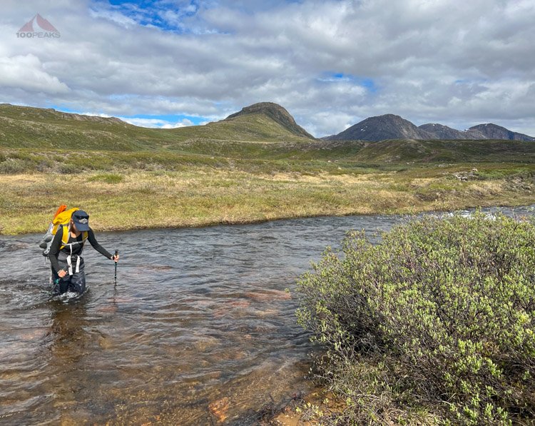
At about 9 miles in, we were ready for a break. We could see one of the river crossings between two lakes below us. The guide indicated that sometimes it could be knee-deep, but we easily used some rocks to hop across, filling our water up along the way.

Creek crossing, break spot, and water fill-up next to Qarlissuit Lake
It was easy to rock-hop across
Just past the crossing, we rested on some rocks and had more snacks. The area was marked as a potential campsite on the map, and it looked like it would be a great spot to spend the night. We had a goal, however.
It was 7PM. We had been hiking almost nonstop for 5 hours and we still had a long way to go.

Looking at the ice sheet at the southern end of Qarlissuit Lake. Our destination hut is the next lake in the distance to the left
The next section climbed steeply up a hill and the mosquitoes entered a new level of vigor. We kept moving just to keep them away, but the wind was at our backs and the pests were attacking us from the front.

The beach along Qarlissuit Lake
After climbing for a while, we finally reached the top of a ridge where we could see a partially frozen lake ahead and the wind picked up, giving us a little break from the pests.


We continued down to the lake side, feet continually getting wet, and saw an arctic hare and another reindeer in the space of a few minutes. The trail led back up to the top of a gap, dropped to a small boggy pond and climbed the other side.

Our first view of Katiffik Hut and Amitsorsuaq Lake
At long last, we could see the Katiffik hut far below us. We would have to drop steeply down this loose hillside to be done for the day. Sophia’s feet hurt like crazy and we were both pretty tired. It was getting close to 10PM, which meant we hiked for about 8 hours on our first day with very heavy packs.
Katiffik Hut with new toilet and empty canoe rack
We dropped to the little arm of land that reached out into the eastern end of Amitsorsuaq Lake which held the tiny Katiffik hut. Hope soared in us as we could see a canoe next to the hut, but dropped when we saw some boots drying at the door of the hut. A brand new outhouse was nearby.
We listened and could not hear any talking inside. It was 10PM and we did not want to wake anyone sleeping. We were hoping to stay in the hut this evening and were surprised that anyone was using it. We also knew they perhaps had pulled up the canoe to claim it for themselves.
After such a long day, we had been hoping for some time off of our feet tomorrow, and some reprieve from the mosquitoes tonight.
While Sophia changed out of her shoes and socks, which would be a mosquito bite mistake, I searched around for a good spot to set up our tent.
The wind abated and the mosquitoes came back. I found a good flat spot for out tent and was walking back to where Sophia was resting by the hut when a man came out of the hut and waved to us, graciously welcoming us inside.
We were elated. They were a couple from Bristol (C and L) and were going to go to bed soon, but told us to take our time and enjoy our dinner.
Sophia and I grabbed our dinner and sleeping gear and got into the hut as quickly as possible, though we were moving like zombies after such a long day with considerable jet jag.
We quickly made dinner while whispering, and, after cleaning up outside and messaging my wife that we had made it, made ourselves comfortable under the shelf in the hut. There were two pads there and we put out our sleeping bags and pillows and immediately went to sleep. It was around 11 PM.
Amitsorsuaq Lake from below Katiffik Hut
Day 2 - Katiffik to Canoe Center - 12.7 miles (~20km)
Arctic Circle Trail Map - Day 2 - Katiffik to Canoe Center (Click to Enlarge)
We woke up at about 7AM and lounged in the comfort of our sleeping bags for a while longer than that.
We all got up for breakfast and got to know each other. This was day 3 for the couple; they had started at Kellyville and had a nice easy day on day one to the Hundesø Hut. They then hiked the longer day to Katiffik. L had recently had a virus and was recovering. They were not traveling as fast as they had hoped.
They indicated that there were no paddles for the shiny new canoe that lay against the hut. A recent entry in the hut logbook indicated that there were two canoes along the trail under a cliff. Unless we find some canoes along the shore somewhere, we’d all have to walk the next leg.
We chatted about all sorts of stuff: other adventures, our real lives, etc. They were considering taking a rest day here, as the previous day had been very warm for them. Since Sophia and I had left later the day before, I am sure we were spared from some of the hottest hours on the trail.

Ready for rain and mosquitoes at Katiffik Hut
As I was getting some items out of my pack outside, I saw a figure descending the steep hill that we all had scrambled down the day before. It was a woman, who I will call M, carrying an enormous backpack.
She said hello and we welcomed her into the hut. Considering the route and length of time that Sophia and I had taken the day before, I wondered where the heck she had come from. She had either left this morning very early, or very late last night. We hadn’t passed anyone on the trail yesterday.
It turns out she was dropped off at Kellyville by a friend late in the afternoon and she had cowboy camped somewhere along the trail for a few hours. Then she had packed up sometime in the night and headed down here. She wanted to eat breakfast and take a nap before she moved on.
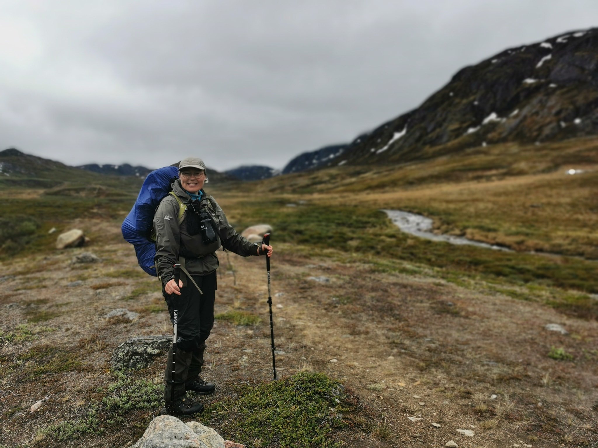
Sophia and I packed up our gear, wearing our rain shells on top and Sophia wore her pack cover. It was sprinkling a little and the day was cold and gray. We were excited to get moving and were happy the day would be cooler and have less gain than the day before, although still just about 13 miles.
We said goodbye to our new friends at the hut, wondering if we’d see them again along the trail. It was just after 12:30PM.

The Arctic Circle Trail along the shore
We were again happy to be along the trail in Greenland, having successfully finished our first day and night. We were also confident there would be plenty of room in the next hut, the Canoe Center, which easily could fit over 20 people, and, in a pinch, fit over 30 people, including the floor.

The trail turns west
We hiked along the beach of the large lake, enjoying the cooler weather and breeze which mostly kept the mosquitoes away. It was still wet and boggy, but we climbed through a bouldery section and had fun scrambling along the lake. We scoured the shore for any signs of canoes with no luck. We climbed over a tall rocky section with a cliff below and still could not see any canoes.

Looking back toward Katiffik Hut

Trail marker on the Arctic Circle Trail
We stopped for a lunch break, still getting used to being in Greenland. The terrain was so vast and spectacular. The ground was different than what we were used to. The lake was huge below us.

The trail climbs high above the lake

Lunch time on the trail
We kept hiking along the wet and undulating trail above the lake for another hour until I saw something shiny and silver ahead.

The trail continues
“Canoe!” I shouted.
“Two!” Sophia replied.
Would could see the shiny underbellies of two brand new canoes. I was relieved. I was getting tired. I was happy to get off my feet, but first we’d have to get down to the shore and see what was there.
We hiked off-trail on soft, spongy plants and made it to the rocky shore. We flipped over the first canoe and found three paddles and one life jacket. There were two paddles and a life jacket in the other one.

Happy on the canoe on the Arctic Circle Trail
Sophia grabbed the life jacket and I left the other one for the other canoe. We also stashed the third paddle under the other canoe. We changed into our crocs and carefully flipped the canoe and scooted it closer to the water. We loaded our backpacks into the center and shoved off.
It was great to be in a shiny new canoe. The wind was at our backs and it was a relief to sit down. In my youth, I had spent many hours in canoes, so I easily picked up where I left off. We’ve also gone on family canoe adventures in Banff and Hawaii.
We glided through the choppy water and our moods were elevated. The shore moved quickly by us on our left. We were sure this was faster than hiking the trail above. We were sure we’d make it all the way to the Canoe Center as we drifted between the shore and the depth of the lake.
About an hour into the ride, my hood blew back on my head. I wrinkled my brow. The tailwind had changed direction, a full 180 degrees, to become a headwind in an instant. I continued paddling, fighting the growing wind and aiming the canoe into the oncoming waves. Progress was harder and slower.
After two hours, we were both getting really cold and tired. The wind was simply blowing too much and the waves were getting larger and more dangerous. I scouted ahead and found a sandy beach with an animal grazing on the ridge above it.

Happy to be off the canoe, we found the perfect beach
I hopped out of the canoe into the water to drag it onto the sand, getting my feet wet. Instantly I was shivering. It was after 5:30 in the afternoon and the temperature was dropping quickly.
I put on my puffy under my shell and we secured the canoe, flipping it high on the beach with the paddles and life vest underneath. We quickly got our shoes and backpacks on, hiking up the slope until we met the trail, which had a plain view of the canoe. It was a perfect spot to leave it.

The tallest cairn on the Arctic Circle Trail
We got hiking immediately to warm up, hiking up to the tallest cairn and seeing that the animal we saw was another reindeer. We continued hiking along the rolling trail above the lake toward a prominent point up ahead and it took about 2 hours to reach it.

Continuing up the coast
From the top of the point, we could see the Canoe Center, still quite a distance ahead and below us. We dropped down to the shore and then up and over a steep hill and back down again. It was one of those moments when we were both ready to be done for the day. It had gotten quite cold and windy.

The Canoe Center Hut comes into view, a red speck in the distance

Large cairn on the beach


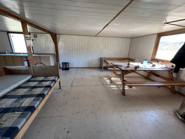
The Canoe Center Hut
We hiked up to the Canoe Center and noticed a lot of reindeer heads and a hide before we walked up the steps and let ourselves in.
It was very large and a welcome sight at the end of another long day. It appeared we would have it to ourselves, unless M or C and L were going to make it by the end of the day.
It was chilly as we had a look around and chose the room to the right of the front door. It had its own picnic table and plenty of bunks. It had a heater, which I wasn’t going to go near. In the foyer, there were two doors. One led to a toilet and the other was a storage room.

The Canoe Center Hut on the Arctic Circle Trail
To the left was the main kitchen, large picnic table, another heater, and a few beds. A brand new large solar charging area with some batteries was on one wall. Since we didn’t have a Euro plug, we couldn’t recharge, but my battery pack would be more than sufficient for the trip. Behind that room was another dorm with another heater and a lot of bunks. This hut would do just fine.


It was 8PM. We hiked and paddled almost nonstop for about 7.5 hours.
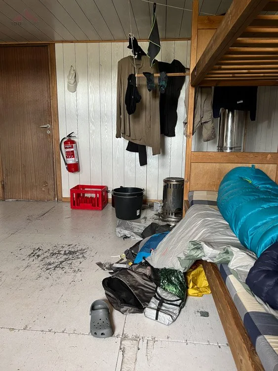
We unpacked some clothes and decided to do some laundry, which consisted of filling a large bucket up with water from the lake and scrubbing our clothes. We didn’t want to have to try to rinse out soap, so we just used the water to get the grime off. We hung them up outside to dry until it started sprinkling, so we brought them into our room and hung them on a line to dry overnight.
I realized that the wide mouth of my Nalgene water bottle was great for getting water from a variety of situations, including a lake. I used that to fill up the bucket, as well as my 6L water bladder.
We were cold and tired, so I grabbed a few tea light candles that someone had left there and we settled into our room on the right.
Cooking dinner and lighting the small candles proved enough to warm up our side room a bit and we settled in for the evening. I placed a square of foam that was in the room in front of the window nearest us to make it a little darker.
We were tired and went to sleep at about midnight, enjoying the silence.
Day 3 - Canoe Center Zero Day - 0 Miles (0km)

Glassy lake in the morning from the Canoe Center Hut
We woke up at 11AM. We slept for 11 hours. We stayed in bed for another hour. We were still tired. We were moving slowly. Our hanging clothes were still very wet.
Laundry day on the Arctic Circle Trail
27 miles or so in two days with heavy packs wore us out. Sophia and I had a discussion. We had built extra days into our trip. We would use one here, in the largest hut. We were going to get some rest and eat a lot of calories. And that’s what we did.
I looked out the window, the lake was glassy. Since the wind wasn’t blowing, we could see mosquitoes swarming outside the hut. We had a relaxed breakfast as we enjoyed the view outside and took turns reading the hut’s visitor log.

A perfect zero day on the Arctic Circle Trail
We played cards. I played one of the guitars that was left there. We read books. We relaxed and enjoyed the views outside the windows as we drank hot apple cider. We snacked on some of the extra food we had brought.

The view from the Canoe Center
At about 2PM, I was walking past the window by the kitchen when I saw M pulling up a canoe to the shore. I opened the door and waved hello. She was happy to see us and came inside. She had left Katiffik a few hours after us and camped somewhere in between, likely near where we had found the canoes.
She hadn’t seen the remaining canoe on the shore earlier on the trail, but had hiked all the way where we had left ours. She excitedly took the canoe into the glassy water and paddled all the way to the Canoe Center.
We got reacquainted and she took out a dark brown loaf of bread, some salami, and a block of cheese. She had asked the baker to not slice the bread, so it wouldn’t get stale as quickly. She ate some and offered it to us. She wanted to reduce the weight of her pack, so we took her up on her offer.
I walked over and picked up the loaf of bread and audibly exclaimed. It was so dense, it was at least 3 pounds (1.5kg)! Of course we would help. It was delicious, but we all laughed about its density.
We chatted for a while until she was ready to take a nap, which she did in the main room, as she said she liked the noise and comfort of people around her. Sophia and I quietly played cards and listened to music in our earbuds.
A while later, as M was looking out the window, she said, “A canoe!”
Sophia and I rushed to the window and saw a distant canoe in the lake, and immediately recognized C’s blue jacket. C&L had made it! It felt like a little reunion as they settled themselves into the dorm in the back. They had found the last canoe at the midpoint and paddled all the way in.
We all chatted for a while until everyone relaxed in different areas. Then M started gathering her things. Once again, she was going to set off, going as far as she could until she would camp for a while before continuing on.
She bundled up against the cold as we said our farewells. She brought her things to the canoe and launched into the dim light of the evening. It was 7:30PM.

M canoeing solo in the distance at 7:30PM
After a while, while glancing out the window at the clouds of mosquitoes and watching some larger flies appear to prey on them, I could see the silhouette of M’s canoe in the distance of the lake. She was on her way.
We had dinner and settled into bed while reading. I finished my book. We fell asleep at 11PM.
Day 4 - Canoe Center to Ikkatooq - 13.5 miles (22km)
Arctic Circle Trail Map - Day 3 - Canoe Center to Ikkattooq (Click to enlarge)
We had another great night of sleep and I woke up to the sounds of C&L getting ready to move on and cleaning up the hut before they left. Sophia was still asleep, so I decided to leave her be while I relaxed on the bunk. I had finished my book the evening before, so I reviewed the guide book’s description of the day.
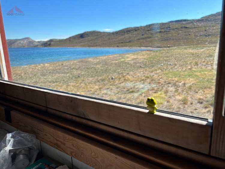
Froggy in the window of Canoe Center Hut
The noises outside our room quieted down at 10AM, so I got up to use the restroom. I peeked out the window and could see them backpacking on the far side of the lake. We should see them at the next hut.

Sophia's art in the Canoe Center Hut journal
I roused Sophia and we had a relaxing breakfast and packed up our things. We left at noon.
The day was sunny with a nice breeze. The mosquitoes were not a bother for the entire first half of the day.

Heading out from the Canoe Center on the Arctic Circle Trail

The Canoe Center on the Arctic Circle Trail, with new solar panels
We walked along the beach and the trail followed the rim of the lake. There were some boggy parts, but we enjoyed some parts that followed some rocky hills that had been burnt in previous fires.

The trail gets higher and rocky at times

The blue waters of Amitsorsuaq Lake
We got to the end of the lake and counted 5 canoes. That accounted for all of the new ones; 5 were here and one was at Katiffik. We had left a note in the cabin log asking if someone would bring an extra paddle back to Katiffik so that the canoe could be used.
We continued following the outlet creek from the lake and entered a broad green valley. There was a use trail that kept to the left, but there were cairns leading high to the right along a ridge. We crossed the creek and, after a short climb, were on a dry ridge top with a view of the valley below. It was a beautiful day and we were in high spirits. We felt strong after our day of rest and were moving at a comfortable pace.

The Arctic Circle Trail follows this wide river valley and heads up to the rocky ridge to the right

Arctic Circle Trail cairn leads the way

The trail continues through the valley below
The trail crossed again to the left side of the valley and attempted to stay high, but we were often walking in water and mud. We took our lunch break on some boulders and enjoyed the view around us. There was a large knobby mountain behind us, a waterfall up ahead to the right, and we could see a large lake far below us. The wind continued to keep the pests away and we enjoyed the time immensely.

Crossing the creek

Looking back along the trail

Reenacting the guidebook cover photo


Cairn leading the way along the shore of Tasersuaq Lake
The trail continued along the lake until it curved to ascend steeply over a pass. At the top, we encountered a ptarmigan family, with several small downy chicks scurrying around and hiding the brush.

Steeply ascending a gap along the Arctic Circle Trail

Ptarmigan pair with hidden chicks
We continued descending the other side, a large sandy beach coming into view. We would have our next break there.

At the top of the rise, overlooking Tasersuaq Lake

Descending to the beach, the trail ascends the cliffs to the left
As we headed down the beach, we looked for a place to sit until we heard our names being called. C&L were having their lunch at the bottom of the hill on the beach.
We joined them as they made their hot lunch. They were surprised to hear that we had left at noon. We reloaded on water and had some snacks. There was a moment where I had to force myself to get water, since the edge of this lake felt like a saline body of water. I felt like I was getting drinking water from the ocean. Once again, my wide-mouth nalgene bottle made it easy to get water. We all agreed this would be a nice place to camp if it fit into our itinerary.

Snack break and water refill on the beach
They were still eating their hot lunch, so we said farewell and started on, certain that we would see them later this afternoon once we reached the next hut. We climbed first gently, then steeply up some green cliffs into the highlands. Although it was quite windy, the mosquitoes came out to say hello.

Time to climb

Wombat Rock

The view down to the beach and Tasersuaq Lake on the way up the cliffs
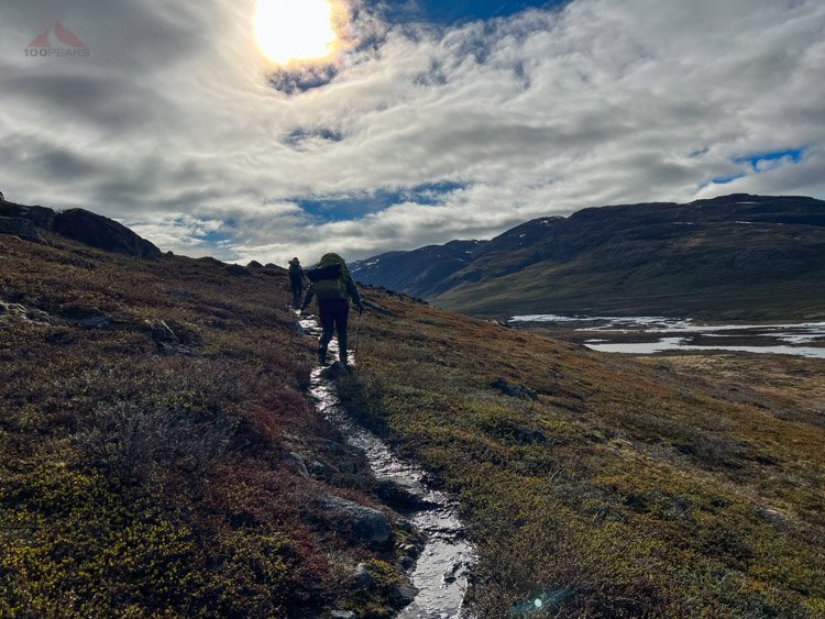
We donned our head nets and applied a coat of DEET and continued on. The views from the high ridges were astounding. We could see the giant Tasersuaq lake to the east, the hills making it look like two lakes. We could also see the snowy mountains to the north. The trail rose and fell, a little more steeply than what the guide described as “undulating.” There were small lakes everywhere and we touched our first snow patch. The trail was almost completely boggy as we climbed and descended, crossing wet drainages, and large ponds. The mosquitoes were relentless, even when the wind started.
Tasersuaq Lake from the top

Arctic Circle Trail cairn up high


We would see distant cairns, high on ridges above us, and knew we had climbs ahead of us. After nearly two hours, we rounded a corner and could see Ikkatooq perched on a pass, far in the distance. The trail dropped near a couple of lakes and climbed the final rise to the hut. We were happy to be there.

Getting closer to Ikkattooq Hut

Ikkattooq Hut with cairn
As we approached, the door swung open and M called out!
We said our hellos and it felt like another reunion. She, once again, had camped out, likely somewhere near where we had seen the ptarmigans above the beach, and had made it to the hut the next morning. She realized she didn’t want to backpack the trail alone and decided to wait for us.
We got comfortable, filling my 6L bladder with water and setting up our beds for later. Removing wet clothes and socks was always a highlight of the day. We arrived at 7:45PM.
The hut was high up in the mountains and was cold, but it was very comfortable for us at the end of a long day. It was yet another spectacular hut location, overlooking the lake below and the mountains and a few small lakes above us.
Since there was no toilet at this hut, and there had been a fire in 2016, it was hard to dig in the ground. As a result, there was a lot of tissue surrounding it, as well as trash that had been placed in a drum outside that had blown across the landscape.

Froggy in the window of Ikkattooq Hut
After Sophia and I entered the hut, it felt pretty hot. Since the wind was blowing, I cracked open one of the rear windows and hung our headnets on it to deter winged visitors. The fresh air was nice until the temperature plummeted and we had to close them.
We made our dinners and chatted about a lot of things. On M’s recommendation, I emailed Hotel Sisimiut and messaged the Air Greenland agent (angel) asking if they could pick up my bag at the airport or how I should pick it up. M mentioned the airport might be closed on Sunday when we will exit the wilderness, so I might want to get ahead of the situation.
We hung up our clothes inside and looked out the back window, scanning for C&L. A reindeer cautiously came by to check out the hut. At 11:30PM, we started settling in for sleep, since we deduced that C&L likely set up their tent somewhere along the trail. The wind had increased and it looked like rain might be in our future.

Reindeer visiting Ikkattooq Hut
I hung my rain shell on some line above the small window next to my bunk to dim the light. We went to sleep about midnight, the wind howling like a train through the night, as we were cozy in our sleeping bags.
Upon scanning my map, I realized that Gaia GPS had only downloaded part of the base map I was using, and suddenly the map was in higher resolution than before, showing more trails and contour lines than before. Apparently, it had been downloading updated maps when I lost a signal. I would have to be more vigilant in the future. I had noted over the past few days that many lakes and trails were not shown on the map. Luckly, my saved routes were showing up just fine and it appeared it would be better, at least for the next few days.
Day 5 - Ikkatooq to Eqalugaarniarfik - ~7.5 miles (~12KM) - Bridge route
Arctic Circle Trail Map - Day 4 (5 for us) - Ikkattooq to Eqalugaarniarfik (Click to enlarge)
We woke up at around 9AM and lounged in the warmth of our bags. M and I chatted from our bunks while Sophia got some additional sleep.
The weather outside was cold and windy. The clouds were low and a blanket of fog lay over the lake below us. We were in no hurry to get started.
Sometime late in the morning, M, who kept looking out the back window, shouted, “Here they come!”
C&L hiked up and joined us in the hut, we had already gathered most of our things so they had room to spread out a little.

Interior of the Ikkattooq Hut
They had hiked until the wind picked up and they decided to camp. It was a very gusty evening, but they were warm and dry in their tent. They realized that they were not going to be able to complete the trail in the time that they had. A flight delay earlier in the week had cost them two days and they had to catch a ferry to Ilulissat. I gave them the numbers to both our boat tour guide that we had scheduled in Sisimiut, as well as Hotel Sisimiut. Perhaps they could message them for a boat to pick them up in the fjord that is near the end of today’s trail.
It sounded like they would make it to the next hut and wait for a boat there. We said farewell and expected to see them later in the evening.
The weather wasn’t improving so we set off at about 1:45PM.
The trail immediately climbed straight up the hillside and continued the climbing and dropping that started the day before. Sophia took off her middle layer, but I was still a little chilly, so I kept mine on. It was raining and had been since early in the morning. We were in the clouds and would see cairn shadows ahead of us, which helped us stay on track, since there appeared to be multiple trails through this part of the mountains. Lakes looked like infinity pools as they disappeared into the mist.

Foggy in the mountains
Given the wetness of the trail, the lateness of the snow melt, and the unending rain for the last 12 hours, we decided that the river crossing was likely to be too deep, unless we wanted to be soaked, perhaps to our chest. On a cold and windy day like today, it probably wasn’t a good idea to try it.
The challenge of this part of the trail is that, when you make the decision between the river and the bridge, you haven’t seen the river yet. Also, there is no trail to the bridge. There is a rough route on the Gaia GPS layer and some vague directions in the guidebook, but really you’re on your own.

A look at the boggy floodplain below, the bridge is somewhere in the mist beyond the sloping left ridge in the distance
We dropped down a steep and slippery trail until we hit a rocky ledge above the boggy floodplain below. We sat and had our lunch. It was about 3:30PM. It was still raining, but at least we had dropped below the fog.
After consulting my map, it appeared that we had already passed the split in the trail that would meet the bridge. In reality, there was nothing on the ground that matched the trail on the map, so this next section would be cross-country.

Entering the bog, soaked to the knees
Since M had more experience through this type of terrain, she took the lead and kept us as high as possible until we hit the floodplain. Immediately, we were up to our knees in water as we crossed numerous grassy creeks formed from the melting snow and rain runoff high to our left.

Waterfall
Our feet would often sink up to our calves in soft grass and mud.
We decided to head up to the base of the mountains to our left and found a faint use trail that followed its contour. It was still wet and boggy, but it was easy to follow and the water only went as deep as our ankles from time to time.
We then, following the guidebook’s advice, hiked to a low rise and continued around two lakes in the plain. Every time we stopped for a short break, the mosquitoes would come to visit and we’d get chilly in the icy wind.

The bridge in the distance
After about 2 hours, we finally saw the bridge in the distance. There was a clear trail the last few hundred feet. We weren’t sure if this was just a fishing trail or somehow this trail made it all the way back up into the mountains.

The bridge over the raging river
We were happy to be done with the trailless part of the trail and crossed the bridge. The river looked deep and swift underneath us. We were confident we had made the right call.
We followed the bridge to the other side of the river and came across a large campsite. There was a lot of trash left behind and trails everywhere. We eventually found a trail leading steeply up the mountainside, per the guidebook. Again there were several trails at the top, but there was a sign high above us that told us we were close to the proper Arctic Circle Trail.

Climbing back up into the hills, looking back to the river and floodplain in the distance
We climbed and climbed until we were confident we were on the right trail at the base of a cliff. The trail was soft and wet, with ATV tracks along it.
It was during this time that I started feeling a shooting pain in my right foot. I don’t remember a singular event, like the rolling of an ankle, that caused it. Every step was a new stab of pain as I started limping in agony up the steep trail to the next hut.

The final soggy climb up to the Eqalugaarniarfik Hut
We passed a large scattered pile of reindeer hides and a discarded white tent in the clearing below the hut and climbed the steps to the mudroom. Two sets of boots were on the floor as a young man opened the inner door to say hello. I was still occupied by my foot and tired and cold from the day, so I wasn’t thinking clearly, but I believe he went back inside to make room for us.
We arrived at 6:30 PM. It is considered the halfway point on the trail.
We took off our wet shoes and layers and entered the hut. It was larger than the last one and we decided that Sophia and I would take the double bunk on the left, the couple would take the right one, and M, per her request, would sleep on the floor, me giving her the pad from the bunk while I slept on my inflatable pad. We wondered where C&L would go.
The couple was from Germany and were hiking from Sisimiut to Kangerlussuaq, the opposite direction as us. We shared trail beta from either direction. They said there were a few crossings tomorrow where we would take off our shoes or throw our packs across or simply hop across. We let them know in detail about getting to the bridge.
They let us know that the water source was about .3 miles (500 meters) to the north on the trail, so M and I went out to collect the water. My foot still hurt in my crocs, so I took it slowly. Hopefully, a night off of my feet would help greatly, as typically I roll my ankles slightly from time to time and I would heal quickly, just walking it off. This time felt different.
We made it back to the hut and M was upset about all of the reindeer hides strewn about. “This is not our way,” she kept saying. She would take pictures and bring them back to the community to prevent this from happening again.
We had dinner and were happy to have a sink that led outside. We hung as many clothes as possible. My down puffy was completely wetted out. This is why I was so chilly throughout the day. It was so humid that I sweated profusely inside and it had collected all my moisture. Sophia had brought her synthetic down puffy off, so it was dry.
The German couple let us know that they would be waking up at 5AM, so they were going to bed at 9PM. We were OK with that, as we were tired and eager to get into our sleeping bags.
We kept looking out the window for C&J coming up the trail or heading to the fjord for a pickup, but Ikkattooq would be the last that we saw of them on the trail.
I messaged my wife goodnight and crawled into the warm sleeping bag, a smile on my face at how comfortable I was to lay flat, get out of the wind and rain, and get off my aching foot. I slept wonderfully.
Day 6 - Eqalugaarniarfik to Innajuatooq II (The Lake House) - 12 Miles (19km)
Arctic Circle Trail Map - Day 5 (Day 6 for us) - Eqalugaarniarfik to Innajuatooq II (The Lake House)
I woke up briefly to the sounds of the couple gathering their gear, but slept through it like a log. They kindly refilled my 6L bladder, since they used it in the morning for breakfast.
We woke up at 9AM and I checked on our clothes. They were still soaking wet. I checked my stove fuel and determined that I had used less than half of one canister. I had plenty of fuel for the rest of the trip.
I set up my stove under the clothes and turned it on. The chilly hut warmed up nicely, too.


We chatted over breakfast and packed up over the next few hours and we watched again for C&L. The day was sunny with a breeze. It looked to be another great day on the trail, which was refreshing after the gloomy cold day yesterday.
By the time we packed up everything, our clothes were mostly dry. Most importantly, my puffy was dry. I have to rely on that in the colder situations on the trail, so it was comforting to know it had regained its loft.
M headed out as we were packing our last few things, sure that we would catch up with her.
The very comfortable Eqalugaarniarfik Hu

The view down to Maligiaq Fjord from Eqalugaarniarfik

Looking back down at the floodplain from the day before
We left at 12:15 PM, emerging into a sunny day with a wonderful view down to the fjord. We crossed the creek where we got water and the trail immediately climbed straight up the side of the hill. We stripped off our layers and put on a coat of DEET. There was an ATV road that we used from time to time.

This day's path leads straight up
My foot hurt immensely, and I resigned to limp the remaining 50 miles of the trail, resting as much as possible in the evenings.

Looking back down with Eqalugaarniarfik Hut far below us

M climbing up the steep trail

One of many creek crossings
As we climbed higher, we were presented with an outstanding view of the valley below us. As we got to the top of the climb, we could see the mountains to the north frame a large, partially frozen, lake below us.

Lake ice and huts below
The trail took a left before it started heading down to the lake, and after crossing a creek, we were on a rocky ridgeline with fantastic views in all directions. We made great time, crossing bogs, but often staying dry as the trail rolled along the top of the ridge.

The Arctic Circle Trail leads left and stays high for a while
Sophia and I were reminded of ridgeline hikes in the Sierra Nevada as the wind kept the mosquitoes at bay for most of this part of the trail. At this point, we started to see evidence of the ATV track; wooden stakes were in the ground at intervals.


Before long, we could see a lake below us to the west and knew we’d be following the far side of that lake and another to the north for a good portion of the day. We encountered another grazing reindeer and stopped to enjoy it.

The trail drops to the lake
We descended steeply to the edge of the lake and enjoyed a lunch break near its shore. Two Danish men were finishing their lunch and making their way up to where we just left. We gave them beta on the bridge and the river crossing for the next day.

Lunch on the smaller of the two lakes we circumnavigated

Getting some cold refreshing water
We headed around the southern end of the lake, staying low near the water for the most part as we trudged in bogs, puddles, mud, creeks, and rivers for most of the remainder of the day. Since our feet were wet, we simply walked through any deep rivers.

The trail next to the lake

One of many large creek crossings
The gorgeous lake below us
The icy water numbed my aching foot as we continued north along the larger lake. We could see the ATV track below us. Some of the track was already cleared and appeared to have been sprayed with herbicide, as brown brush lay down on it.
The trail merged with the ATV track and we followed it along the lakeside, sometimes going easy and sometimes in very deep mud.

Following the ATV track by the lake as the day gets cooler
The trail turned west at the end of the lake and we climbed a marshy pass that looked down into a broad green valley ahead. The ground glistened ahead of us and the bog was continuous as far as we could see. The valley turned northwest.

Climbing up and over to the next valley
As the pain in my foot grew, I started slowing down. Sophia took the lead and shot off ahead, keeping us on the trail. I was proud, she was clearly enjoying this and showing a lot of strength. I started taking tons of pictures of this beautiful valley and the giant waterfalls pouring down the cliff around us and of my daughter showing leadership and confidence.

Another creek crossing

Waterfall
The sun was shining and it was a gorgeous day. We were also excited to be arriving at, from all reports, the best hut on the trail.
The lovely lake in the broad valley, still with some lake ice

Sophia leading the way, the trail follows the valley around the corner to the left
The wet trail turning left into the next valley
We kept to the left of the river and lake at the bottom of the valley and turned the corner to the west and climbed up to a junction in the trail. We headed right towards another rise until Innajuatooq II (The Lake House) came into view.

Getting closer to the Innajuatooq Huts

Our second signpost on the Arctic Circle Trail
We excitedly hiked to the hut and found it to be empty, spacious, and full of sun, with spectacular views of the lake and the mountains around us. It was about 7:15PM.

The last few feet to Innajuatooq II Hut, The Lake House
We immediately did laundry and had a yard sale, hanging all of our wet clothes in the sun and breeze. I took a swim in the lake, taking advantage of the warm sun. It was invigorating, surrounded by the towering mountains. I swam out to touch the ice layer. It was very cold, but I didn’t want to get out. It was wonderful.
Innajuatooq II, The Lake House
I made it back to the cabin and put on dry clothes, but my skin tingled nicely for a long while afterward. Nothing can make you feel better after a long day than taking a dip in an icy lake.
M also had some time in the lake after I was done. The sun then abruptly went behind the mountain to our north and the temperature dropped. We had made it just in time.
We got settled in, Sophia and I taking a large back room filled with bunks and a heater, while M took the front room on one of the bunks. We sat at the picnic bench and had some snacks. This hut also had a toilet and a sink. We set up our food and stoves on the kitchen counter.

The view from the kitchen window of the Innajuatooq II Lake House
This was one of the highlights of the trip. We were all glowing from a beautiful day on the trail, the dips in the lake, and the comfortable hut. I found some brownies my wife had made that I had forgotten about and shared them with the team. M shared some candy bars with us and the mood was festive.
Hiker hunger had set in. We took an inventory of our remaining food and determined that we had plenty, so we snacked and snacked. We shared our experiences, and M taught us a lot about Greenlandic culture.

The view from the western window of Innajuatooq II Lake House at 11PM
We laughed and laughed about all sorts of things, and before we knew it, it was 11PM. Time flies when you're having fun.
We got settled into bed and fell asleep about midnight. We were happy and content.
Day 7 - Innajuatooq II (The Lake House) to Nerumaq - 10.5 miles (17km)
Arctic Circle Trail Map - Day 6 (Our day 7) - Innajuatooq II (The Lake House) to Nerumaq (Click to enlarge)
We woke up to rain, which created rings of water on the mirror of the lake. I used my stove to warm the hut and dry our clothes.
We took our time having breakfast and enjoying the hut, hoping the weather would improve, or at least stop raining. However, at 1:30PM, we headed out into the wind and rain.

A rainy day on the lake
The guidebook described the day as:
“Apart from an initial gentle climb from a lake, the route is mostly downhill, passing fairly easily through a valley flanked by mountains.”
Once again, it under-describes the experience and gives the expectation of an easy day.

Bundled up and ready to go
We left the hut and immediately crossed the river to the north, finding a wider, shallower section half-way between the two lakes. M slipped on a rock in the middle and fell into the icy water, but she was fine, belly-laughing at the situation. It wasn’t her first time.

Our widest river crossing

Looking back toward Innajuatooq II, The Lake House

Innajuatooq II, the Lake House
We continued along the right side of the lake heading toward a hill in the distance. Once again, nearly the entire trail was boggy and we were sloshing along, feet wet. We saw a reindeer trot up the mountain ahead of us.
And, once again, my foot was screaming at me, with no real relief except at icy water crossings.

The lake is lost in the clouds behind us - Photo by M
We climbed into the clouds and the temperature dropped. I was hesitant to put on my puffy, as I didn’t want it to wet out, so I was a little chilly during breaks. We encountered a Greenlandic man in the tent as we neared the top of the pass. He was waiting out the storm, waiting for a break in the weather.
Climbing high into the clouds, to cross snow fields - Photo by M

The clouds limited visibility and kept it a little chilly - Photo by M
We continued climbing in the clouds and stayed high on the mountain for hours. I was so eager to keep moving to stay warm, I didn’t take a photo for three hours. We crossed our first snow fields in the mist and continued to climb and descend until the trail started to drop into a large wide valley. We saw another family of ptarmigan.

Ptarmigan up high

The Arctic Circle Trail through the fog
We saw another reindeer in the mountains across the valley, and more on the mountain above us. The trail stayed high away from the river until it dropped onto a sandbar. It was another one of those days where we turned a corner, hoping to see the hut, but we would then be met with more of a corner.

Dropping below the cloud layer into the wide valley below

Looking back up the valley
M is unstoppable

Continuing along the valley
The views of the wide glacial valley and the mountains beyond were breathtaking. There were often giant waterfalls streaming down from snow-covered mountains. The flowers were blooming and the birds were flitting about. The rain had stopped a while ago, though it was still cloudy, a fluffy roof above us.

Getting close to Nerumaq Hut
We took a last snack break and headed around the corner, the trail meeting the ATV track again. We made it to the hut, which was the same style as Ikkatooq. We got comfortable, but it was very cold. We could see our breaths. I closed the vents, which helped, as we hung our wet clothes and got settled. The foam pads were pretty dirty, but we just covered them again with our uninflated sleeping pads.

Nerumaq Hut in the distance
We arrived at 7:40 PM.
Once again, we had wonderful conversations until it was time for bed. Our thoughts often turned to food as we made our packs lighter by eating dinner and snacks.
At this point, we were all used to wet feet all day. We would change into dry clothes for the evening and change back into wet clothes and socks in the morning.

Nerumaq Hut
We were comfortable in bed and sleeping by 11:30 PM.
Day 8 - Nerumaq to Kangerlusarsuk Tulleq Syd - 10.5 miles (17km)
Arctic Circle Trail Map - Day 7 (Our Day 8) - Nerumaq to Kangerlusarsuk Tulleq Syd - (Click to enlarge)
Since the morning was so chilly, we lounged in our sleeping bags a little longer. We knew the weather would be better today, but we weren’t sure when.

Nerumaq interior

Nerumaq still life
There was a layer of condensation over everything in the hut, so perhaps I shouldn’t have closed those vents. We were low in a very damp valley. I reopened them.
The valley around Nerumaq
I left the hut to take some photos and, once again, noted that these huts are in very scenic locations. The walls of the valley soared high above us. The river roared nearby. I strolled around just to take it in.

Getting ready to leave Nerumaq
We packed up and left at 12:40 PM and crossed the river. Once we were across, we could see L&E hiking past the hut, looking for water. We waved hello and continued on our way.

Crossing the first river outside Nerumaq Hut
Nerumaq Hut Pano
The clouds slowly thinned but never completely went away. The sun came out for most of the day, with a strong breeze.
Our packs were lighter and this was to be the easiest day in terms of elevation change. We made great time on the trail, crossing creeks and a stand of willows that were higher than our heads. Our feet were still wet, but it just came with the territory. The pain in my foot quieted down to a dull roar for the middle of the day.
Looking back up the valley

Our path ahead along the Arctic Circle Trail
We stayed on the left side of the valley, rolling along with the terrain, until a large rocky gorge appeared, swallowing the river ahead of us. We crossed the river again with no issue and had lunch at a small rocky ridge rising from the middle of the valley. The mosquitoes greeted us enthusiastically until we finished and moved on.
Another river crossing
After lunch, the trail passed the gorge and crossed the river to the left one last time.

The Arctic Circle Trail
The valley opened up even more with the stunning river below and the sun shining upon us. The breeze became more consistent and we were constantly telling each other how gorgeous this all was. This was one of our favorite moments along the trail.

Enjoying the beautiful day on the Arctic Circle Trail - Photo by M
The river widens

More waterfalls above
We walked along the shore of a lake until the trail rose sharply up a hill. From the crest, we could see the nearby fjord, and many huts, two of which were for Arctic Circle Trail use. We aimed for the southern hut, further along the trail, even though it is smaller than the northern one. We wanted to shorten the total overall mileage of the trail at this point. We would also reduce the amount of climbing we’d have to do on the final day.

The trail on the beach

Soph enjoys the hike, with a private hut above

Looking down toward Kangerlusarsuk Tulleq Nord and the fjord
We walked the gradual uphill climb to the hut and found it to be spectacularly situated. We arrived at 6:30 PM.
The hut was of the smaller style of Katiffik. M opted to sleep below the shelf, while Soph and I set our sleeping gear up top. There were plenty of gas canisters and some oats, which we saw often on the trail.

M approaching Kangerlusarsuk Tulleq Syd
I walked about half a mile round trip (800m) to the water source southwest of the hut and surmised that I could have stopped about ⅓ mile (500m) east of the hut to pick up water while we were on the way up. It would have saved the extra trip and reduced the extra gain and loss of elevation.

Kangerlusarsuk Tulleq Syd perched high on the mountain
The sun was still shining so we dried some clothes at the back of the hut. I sat on the bench outside at the back and enjoyed the last rays of the sun and the view ahead to tomorrow’s hike as the breeze kept the mosquitoes away. We could see some rain falling in a valley across the fjord, but it was 4-5 miles away from us and would not come near.
Kangerlusarsuk Tulleq Syd has a spectacular view
I put on my driest and cleanest clothes and we all enjoyed our final night on the Arctic Circle Trail.


We ate plenty, joked around, and enjoyed the massive views outside. By now, we were very familiar with each other and the laughter was constant.
Our packs were light and empty; we would be getting real food, showers, and beds the next night. We slept comfortably at midnight, but set the alarm for 8AM, so we could get an earlier start. We didn’t want to reach Sisimiut too late.
Day 9 - Kangerlusarsuk Tulleq Syd to Sisimiut - 12.5 miles (22km)
Arctic Circle Trail Map - Day 8 (Day 9 for us) - Kangerlusarsuk Tulleq Syd to Sisimiut (Click to enlarge)
We woke up at 8 AM. It was our last day on the Arctic Circle Trail! It was another sunny and windy day. We ate breakfast and packed up. Our packs were small and light.

Froggy in the window of Kangerlusarsuk Tulleq Syd
The views again were amazing, with the shining fjord and lakes below us, with mountains as far as we could see.

The rear of Kangerlusarsuk Tulleq Syd, where we hung our clothes and sat on the bench
Eager to get going, we left the hut at 9:15 AM.

Heading out from Kangerlusarsuk Tulleq Syd Hut
The trail followed the fjord, and at this point, it was hard to imagine salt water. We crossed countless bogs and creeks until the trail turned left and headed straight up the mountainside and climbed for quite a ways.

The Arctic Circle Trail along the fjord
Many cascades along the trail made from melting snow
As we ascended, we chose to stay together, as snow fields started to show up. This was the section where we weren’t sure how much snow we’d have to cross. Some reports indicated waist-deep snow, but we were cautiously optimistic.

A look back to the fjord as we climb steeply up
Along the way, we could see the mountaintop toilet that is used by the locals who put on a race in the area every winter.

The most interesting toilet on the Arctic Circle Trail
We had a great time navigating the snow fields, bogs, and the river that flowed through the bottom of this high valley. Often we would climb halfway up the valley wall on the north side of the valley to avoid snow fields and bogs. The mosquitoes, despite all the snow, were out in force.

Hiking in the snowy highlands - Photo by M

Cairns lead into the snowy valley
The valley wall would often be spongy but dry. We took a lunch break overlooking the valley and, once again, the Arctic Circle Trail did not disappoint, providing us with another new view of the area.

We stayed high on the right side of the valley, as much as we could, to stay out of the snow, marshes, and river

Hiking along the boggy riverbank - Photo by M

Almost out of the snow
We continued on. Sometimes we’d be calf-deep in an icy pond or we’d be thigh-deep while crossing a snow field, but we enjoyed ourselves as we figured out how to get through the area with the least resistance.

Nasaasaaq in the distance, with one final large river crossing
We finally started descending and the snow patches went away. We were presented with a jaw-dropping view of the valley below the mountain called Nasaasaaq, a prominent mountain in the Sisimiut area. The river twinkled below us in the green valley under the snowy mountains. We stopped to take it all in.


We descended easily into the valley, and crossed our final real river crossing. I stopped in the middle to savor it and cool my aching foot.
On the other side of the river, we climbed the slow gradual climb to the pass up ahead, near a ski lift.
After all the miles, this seemed to last longer than expected. We started to meet day hikers, such as a Greenlandic woman training for her trek of the Arctic Circle Trail the following week, and a group of trail runners who stopped to chat and let us know that we had about 5km left.
Once we made the pass, M called her mom, her daughter, and her boyfriend. She requested three sodas for all of us to be waiting at the end of the trail.
We continued downhill, crossing another river a couple of times, zig-zagging through ATV tracks, and gradually getting a better view of the charming town of Sisimiut.
Sisimiut comes into view
We continued downward until we met M’s boyfriend (and his daughter and her friends). He presented us with the sodas and we gladly accepted. We chatted for a bit until we all started strolling on the wide dirt road that leads into town.

Our team at the end of the Arctic Circle Trail

The final cairn on the Arctic Circle Trail
Sophia and I were giddy. We had done it. We felt strong. We were ready for a night in a hotel and some fresh food. We could hear the sled dogs howling below us.
We said hello to a couple of sled dog puppies and said goodbye to M and her family as they got into their car.

Soph meets some husky puppies
You never know who you’re going to meet on the trail or what the flavor of adventure would be. Sophia and I discussed it at length and we were both very happy to have met M. We all formed a great team, each with our strengths. We lifted each other up and made the trip that much better. M’s ability to laugh at adversity, her kindness, and her willingness to be a part of a team was a highlight of the whole trip.
I am not sure if we’ll ever see each other again in person, but we have since connected online and shared photos and thoughts. With M with us along our adventure, the Arctic Circle Trail just felt more Greenlandic somehow. Somehow better.
We continued along to walk to the hotel, arriving at 5:15 PM.
We checked into the hotel and were happy that our room was ready. Our clean clothes, however, were not. My bag was still at the airport, hopefully. The restaurant would open at 6PM. We went to our rooms and were happy that there were robes available. We would shower and sleep in the robes until we were able to clean our clothes.
We both stuffed some dirty clothes into a laundry bag and I brought it down to the front desk, thinking we may have to wait a few hours for some clean clothes. The front desk attendant let me know that their deadline for laundry was 10AM for it to be delivered the next day. It was already 5:30, so we would be able to get our laundry two days later. We were checking out at 8AM, in two days, so not only was I worried we wouldn’t have clean clothes for tomorrow, but we might not even get it back before we checked out.
She said she would try to clean the clothes as soon as possible.
Still in my dirty trail clothes, I waited in our room for the restaurant to open. I called Air Greenland to see if I could take a cab over there and pick up the bag, but the airline was closed. There was no way to contact them or the airport. Since there were no flights in or out of the airport at the moment, it was likely no one was there at all. I would have to think of a plan for having clean clothes the next day. I was again a victim of my oversight.
I then went down and ordered two burgers, fries, and soda. It was delicious and the staff in the restaurant was very friendly and helpful.
I met a couple of Americans who said a couple from Bristol had made it out and caught the ferry to the north. I was happy knowing that C&L had made it out without any large mishaps.
We finished our burgers in no time and were ready to relax, so I took a shower, washing my dirty clothes in the process and hanging them to dry.

Sisimiut midnight sun from our hotel window
We relaxed, happy to not be walking and to be in comfortable beds in a quiet hotel. I looked out the window as the midnight sun shone on the mountains across town.
We both went to bed, listening to the howling of sled dogs below.
Post-adventure
Day 1 - Sisimiut
I woke up early the next morning and decided to take a cab to the airport. I put on my clean clothes, washed and hung the night before, and the front desk called the airport and confirmed that my bag was there. I was relieved. She called a cab that was there in just a few minutes. I think the driver lives only a few hundred feet from the hotel.
He did not speak a lot of English as I looked out the window at the town. I looked at the dark rock covered in green moss on the hillside above the road and was instantly taken back to the Arctic Circle Trail. We went over a bridge and were at the airport in no time.
I walked in and saw that there was only one customer ahead of me. When I got to the front, I said my name and she immediately recognized it and said, “We have your bag.”
I thanked her profusely and paid the inexpensive charge and brought the bag back to the taxi, who I had asked to wait for me.
I rode in the back of the cab, happy to have overcome this logistical snag. It was a beautiful sunny morning and the city was waking up.
I carried the bag back up and woke up Sophia. It was time for breakfast, which was included with the room. Now in clean clothes, we went downstairs and enjoyed a relaxing and delicious buffet of eggs, bacon, bread, jam, honey, and pancakes. The fresh coffee and orange juice was also a delight. We were the only guests there and had the place to ourselves.
We went back to our room to relax for a bit and I saw an email come in. SAS airlines, our ride back home from Copenhagen, had gone on strike and our flight was likely to be canceled. I spent two hours on my phone attempting to find other flights, but all the airlines’ websites were getting slammed with traffic and they were timing out before I could book anything.
I called my wife at 6:45AM PST and asked her to help us out and get us home. She spent the next day and a half scrambling to find something that worked. She had the same problem as me, flights disappearing and becoming unavailable after she entered all of our information.

The charming homes of Sisimiut
Right about this time, I received a call from the boat captain who was going to give us a 2-hour tour. He wasn’t feeling well and ended up testing positive for COVID later. This was OK, since we needed to focus on our flights, but I did see a lot of photos of whales near Sisimiut over the next few days from other boat tours.
My wife eventually got us a flight leaving a day later than planned, with a 12-hour layover in Amsterdam, leaving us with an extra full day in Copenhagen. Definitely not the end of the world. She booked us at a hotel near the Amsterdam airport and I extended our stay in Copenhagen.
We were ready to stroll down to the water’s edge to to enjoy the Sisimiut.
With my foot still aching, I limped with Sophia out into the town and we had a light lunch from the market shelves and sat on a bench, watching the people and cars drive by as we ate. L&E walked by with their backpacks. They had just completed the trail. We chatted about our experiences before they headed to the hostel to get settled in.

Sisimiut inlet
We continued through town, enjoying the sun and the difference in culture. We made it all the way to the harbor and walked around to a little inlet. It was very charming. We hiked back up the hill to the museum to visit the historic buildings. It was a fascinating insight into the indigenous cultures of Greenland. We waved hello to M’s boyfriend’s daughter at an archeological excavation, with many animal bones and fabric pieces.
The Sisimiut harbor view
We did a little shopping and had some ice cream while we had a much-needed video phone call with my wife. We had a great time chatting about our trip.
We continued our stroll through the town and ended up back at the hotel, ready for dinner. We had another delicious meal at the restaurant. It was closed to non-hotel guests, as they had a very large banquet occurring in one of their rooms. L&E strolled in to have dinner, but they were turned away, as they weren’t guests. We tried to get the hotel to add L&E to our table, but the restaurant was slammed. I was always happy with their smiling service.

Hotel Sisimiut
We went back to our room to pack up for our flight the next morning and to relax. We were completely charmed by Sisimiut.
At 10 PM, fireworks went off down the street. Someone with ties to the USA was celebrating our Independence Day. It was July 4th.
Day 2 - Sisimiut to Kangerlussuaq to Copenhagen
We got up early, as the agent yesterday had told us to get to the airport at 8:00 AM and the cutoff for checking in luggage was 9:05 AM. We were the first ones at the airport and the majority of the other passengers arrived well after nine. We were hungry for breakfast, but there were two vending machines that only took Danish Kroners. The vending machine with food had one candy bar on the bottom row. We were content with waiting until Kangerlussuaq to have breakfast.
The flight was quick and easy from Sisimiut to Kangerlussuaq. Our large bags were checked all the way to Copenhagen, so we went straight to the cafeteria and had some breakfast. It hit the spot. We took the opportunity to browse the souvenir shop and stretched our legs. Before long, it was time to go through security and board the next flight.
The gate agent was the same woman who helped us all those days ago. We both expressed our many thanks as she recognized us and wanted to make sure we got our bag. We let her know she was a lifesaver.
We hopped on the 5-hour flight to Copenhagen and arrived late in the evening. We collected our bags and walked to the hotel nearby. We had a late dinner and called it a day. We were tired and slept a long time.
Day 3 - Train to Malmö

Malmö
We woke up late. Jet lag was in full effect.
We had all day to spend, so we relaxed in the room, went downstairs for a light breakfast, and hopped on a train at the Copenhagen airport to Malmö and had a late lunch there. It was a charming city with squares and parks. We enjoyed our seats facing Lilla Torg and then strolled around the Kungsparken, a lovely park.
We loved Malmö. It was exactly what we needed. The train ride was short, easy, and affordable. The city is very walkable and we enjoyed ourselves there, especially in the park.


We returned by train and had a later dinner at the hotel and packed up once again for two more legs of flying.
We did another round of laundry at the hotel for the next two days. Once again, we slept late.
Day 4 - CPH to Schiphol
Once more, we had a relaxing morning, taking our time since the flight was in the afternoon.
We strolled over to the airport early and checked in at a mellow counter, happy that our large bags will be checked all the way to LAX.
After a short flight, we arrived at Schiphol airport in Amsterdam and walked to our hotel. We checked in and got settled, but were eager to have a glimpse at the Amsterdam city center.

Amsterdam at night
We walked back to the airport and caught a cab and made it to Rembrandtplein at 9:30. We were eager to eat some Vietnamese food, but encountered two restaurants that closed early.
We got some food along Rembrandtplein and strolled around town for a while until we were ready to return to the hotel to pack and go to bed. We had an early flight out, so wanted to get there in plenty of time.
Day 5 and 6 - AMS to LAX and HOME!
We walked to the airport at 6AM and found it completely packed with people waiting in line. We heard someone come up to the line and ask, “Is this for security?”
“This is for everyone,” they replied.
I scanned the lines and noticed that many people had carts and a lot of luggage, so I was sure it was for people checking in. I already had my boarding pass since Copenhagen, so I scanned for signs through the throngs of people.
I saw a sign that read “ALL GATES” beyond all the people and squeezed through the crowd and joined a few people going through a walkway. We emerged into the security line and got through easily and efficiently. Out of all the airports, save Sisimiut, which had no security, this was the easiest to flow through, once we got past the mass of people.
We were in the airport and had a hearty breakfast and waited for our flight. We settled into the plane and had a quiet and uneventful flight home. I slept for over 3 hours, which is a lot for me on a flight.
We landed at LAX, got through immigration, and my wife met us at the airport in the Los Angeles heat. It was great to be in the US, but we still had a three-hour drive home through traffic, a big difference from the silence of the Arctic Circle Trail.
Epilogue
We were gone from home for 18 days, one of the longest times I’ve been away from my wife while I’ve been traveling since we’ve been married. Technology lessened the distance between us, softening how much I missed her. A little.
It’s been three weeks since we’ve returned and we still constantly talk about this trip. From the sheer number of places we visited, the natural beauty of Greenland, the Greenlandic people, and the pure adventure of it all, we find ourselves changed for the better.
We keep on sharing stories about M, A, L&E, C&L, and the beauty and harshness of the trail. The sheer scope of it all. These adventures have a tendency to get under your skin and stay there. Through the years, we’ve realized the importance of getting out into the wilderness, but also the impact of the people we meet along the way.
We assumed we would have much of the trail to ourselves, given how early in the season we went. But we met some people and traveled with one. We hadn’t anticipated enlarging our trail family, but it worked out perfectly.
The silence of the Arctic Circle Trail brought all sounds into focus. The single daily flight of the propeller plane between Kangerlussuaq and Sisimiut was an expected, but very brief cacophony. Any bird’s call would pivot our heads around to search for the origin. A bumble bee would stir us out of our reveries. A ripple from a lakeshore or a murmuring creek would be welcome companions.
Once again, my daughter showed me how much she’s grown. She faced difficult challenges and persevered, having fun in the process. We treasure these moments together and are already planning our next trip.
A little shorter next time. But the one after that might be longer.

Our Happy Team, somewhere on the Arctic Circle Trail

